Pretty Beach is a south-eastern suburb of the Central Coast region of New South Wales, Australia on the Bouddi Peninsula. It is part of the Central Coast Council local government area.

Kanwal is a suburb just west of the Tuggerah Lake in the Central Coast region of New South Wales, Australia. It is part of the Central Coast Council local government area and is approximately 9 km north east of Wyong and 6 km west of the Pacific Ocean.

Tuggerah is a large commercial hub and a suburb of the Central Coast region of New South Wales, Australia. Tuggerah is situated on the Main North Railway Line and Pacific Motorway, and is located approximately 91 km north of Sydney and 68 km south of Newcastle. It is the second largest business hub, major shopping area and financial district for the Central Coast after Erina.
Halekulani is a suburb of the Central Coast region of New South Wales, Australia. It is part of the Central Coast Council local government area. Its name is a Hawaiian word meaning "house befitting heaven".

Box Head is a coastal locality in the Central Coast Council local government area located on the Central Coast of New South Wales, Australia. It is within Bouddi National Park which includes the island of Lion Island.

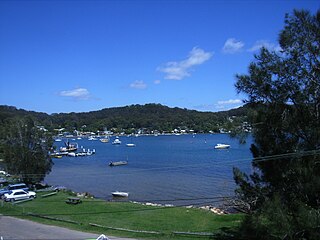
Kincumber South is a south-eastern suburb of the Central Coast region of New South Wales, Australia. It is part of the Central Coast Council local government area.
Little Wobby is a suburb of the Central Coast region of New South Wales, Australia, located on the north bank of the Hawkesbury River. It is part of the Central Coast Council local government area.

Mooney Mooney is a small waterfront village and suburb of the Central Coast region of New South Wales, Australia. It is located in the Central Coast Council local government area at the end of a peninsula extending southwards into the Hawkesbury River, that is situated 50 kilometres (31 mi) north of Sydney. Mooney Mooney has two islands which are Peat Island and Spectacle Island

Mooney Mooney Creek is a suburb of the Central Coast region of New South Wales, Australia, located 60 kilometres (37 mi) north of Sydney along both sides of the river after which it is named. It is part of the Central Coast Council local government area.

North Avoca is a south-eastern suburb of the Central Coast region of New South Wales, Australia between Avoca Beach and Terrigal on the Tasman Sea coast. It is part of the Central Coast Council local government area.
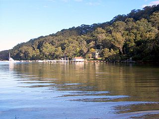
Phegans Bay is a suburb within the local government area of the Central Coast Council on the Central Coast of New South Wales, Australia.
Point Clare is a suburb of the Central Coast region of New South Wales, Australia located approximately 75 kilometres (47 mi) north of Sydney and 4 kilometres (2 mi) south-west of Gosford's central business district on the western shore of Brisbane Water. It is part of the Central Coast Council local government area.

St Huberts Island is a canal estate and suburb of the Central Coast region of New South Wales, Australia connected to the mainland at Daleys Point. It is part of the Central Coast Council local government area.

Spencer is a suburb of the Central Coast region of New South Wales, Australia. It is located on the north bank of the Hawkesbury River just upstream of that river's confluence with Mangrove Creek. Spencer is part of the Central Coast Council local government area.

The Mooney Mooney Creek, a perennial river that is part of the Hawkesbury-Nepean catchment, is located in the Central Coast region of New South Wales, Australia.

Huntleys Cove is a suburb on the Lower North Shore of Sydney, in the state of New South Wales, Australia. Huntleys Cove is located 9 kilometres north-west of the Sydney central business district, in the local government area of the Municipality of Hunter's Hill. Huntleys Cove sits on the peninsula between Tarban Creek and the Parramatta River.
Mangrove Creek is a suburb of the Central Coast region of New South Wales, Australia, located about 14 kilometres (9 mi) upstream and north of Spencer along the Mangrove Creek watercourse. It is part of the Central Coast Council local government area.
Morning Bay is a road-inaccessible suburb and adjoining bay in northern Sydney, in the state of New South Wales, Australia. Morning Bay is located 40 kilometres north of the Sydney central business district, in the local government area of Northern Beaches Council.

Elvina Bay is a bay and adjacent suburb in northern Sydney, in the state of New South Wales, Australia. It is located 35 kilometres north of the Sydney central business district, in the local government area of Northern Beaches Council.

Lovett Bay is a suburb and adjacent bay in northern Sydney, in the state of New South Wales, Australia. It is 36 kilometres north of the Sydney central business district, in the local government area of Northern Beaches Council.

