
Stanthorpe is a rural town and locality in the Southern Downs Region, Queensland, Australia. In the 2021 census, the locality of Stanthorpe had a population of 5,286 people.
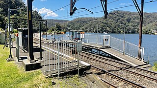
Wondabyne railway station is a heritage-listed railway station and request stop located on the Main Northern line in New South Wales, Australia. It serves the southern Central Coast area known as Wondabyne and opened on 1 May 1889. It is the only station in Australia that does not have road access.

Camellia is a suburb of Sydney, in the state of New South Wales, Australia. Primarily industrial with no residential population, environmental remediation commenced in late 2015, with the suburb ear-marked as a major centre for future high density living.

Mount Perry is a rural town and locality in the North Burnett Region, Queensland, Australia. In the 2021 census, the locality of Mount Perry had a population of 487 people.
Woongarrah is a suburb of the Central Coast region of New South Wales, Australia. It is part of the Central Coast Council local government area, as well as part of the Warnervale development precinct.

Wyong Creek is a suburb of the Central Coast region of New South Wales, Australia. It is part of the Central Coast Council local government area. In the 2021 census, Wyong Creek had a population of 476 people.
Cogra Bay is a locality of the Central Coast region of New South Wales, Australia, located on the north bank of the Hawkesbury River 51 kilometres (32 mi) north of Sydney. It is part of the Central Coast Council local government area.

Dangar Island is a forested island, 30.8 hectares in area, in the Hawkesbury River, on the northern outskirts of Sydney, New South Wales, Australia. Dangar Island is a suburb of Hornsby Shire and as at the 2021 census had a population of 313, which swells dramatically during holiday seasons. The island is serviced regularly by Brooklyn Ferry Service and departs from Brooklyn and takes about fifteen minutes. The Brooklyn ferry is itself adjacent to Hawkesbury River railway station. The ferry service is in operation 7 days a week.

Pindar Cave is a geological formation which appears as a massive concave of overhanging sandstone rock. It is located west of Woy Woy which is north of Sydney, Australia in Brisbane Water National Park.

Karara is a rural town and locality in the Southern Downs Region, Queensland, Australia. In the 2021 census, the locality of Karara had a population of 128 people.
Haden is a rural town and locality in the Toowoomba Region, Queensland, Australia. In the 2021 census, the locality of Haden had a population of 235 people.

Degilbo is a rural town and locality in the North Burnett Region, Queensland, Australia. In the 2021 census, the locality of Degilbo had a population of 182 people.

Ballandean is a rural town and locality in the Southern Downs Region, Queensland, Australia. The town has a number of nearby vineyards which attracted tourists to the area. In the 2021 census, the locality of Ballandean had a population of 316 people.

Allan is a rural locality in the Southern Downs Region, Queensland, Australia. It was formerly known as Sandy Creek. In the 2021 census, Allan had a population of 91 people.

Toolooa is a suburb of Gladstone in the Gladstone Region, Queensland, Australia. In the 2021 census, Toolooa had a population of 992 people.
Lyra is a rural locality in the Southern Downs Region, Queensland, Australia. In the 2021 census, Lyra had a population of 35 people.

Didcot is a rural locality in the North Burnett Region, Queensland, Australia. In the 2021 census, Didcot had a population of 85 people.

Thane is a rural town and locality in the Southern Downs Region, Queensland, Australia. In the 2021 census, the locality of Thane had a population of 19 people.
Mullett Creek is a rural coastal locality in the Bundaberg Region, Queensland, Australia. In the 2021 census, Mullett Creek had a population of 67 people.
Dirnbir is a rural locality in the North Burnett Region, Queensland, Australia. In the 2021 census, Dirnbir had a population of 59 people.

