
Linden is a village in the Blue Mountains of New South Wales, Australia. It is in the City of Blue Mountains, 82 km west of Sydney and 23 km east of Katoomba. The village is on the Great Western Highway and has a railway station on the Main Western railway line served by NSW TrainLink's Blue Mountains Line. It shares a post office, and therefore the 2778 postcode, with adjoining Woodford. In the 2011 census, its population was 594, including 19 indigenous people (3.2%).
Magenta is a coastal location of the Central Coast region of New South Wales, Australia. It is part of the Central Coast Council local government area, and contains a significant portion of the Wyrrabalong National Park.

Woodford is a village in the Blue Mountains in New South Wales, Australia, about 90 kilometres west of the Sydney CBD. Its elevation is 609 metres (1,998 ft) above sea level. It is situated on the Great Western Highway and has a railway station on the Main Western railway line served by NSW TrainLink's Blue Mountains services. At the 2016 census, Woodford had a population of 1,934.
Blacksmiths is a coastal suburb of the City of Lake Macquarie in New South Wales, Australia adjacent to the Pacific Ocean 24 kilometres (15 mi) south of Newcastle's central business district, between the suburbs of Belmont and Swansea
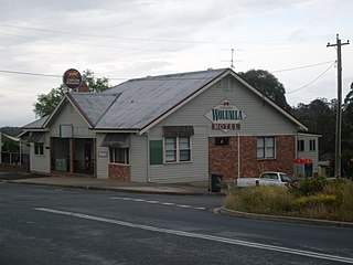
Wolumla is an historical locality in New South Wales, Australia located 234km south of Canberra, between Bega and Merimbula. Wolumla is located on the hilly coastal hinterland near the headwaters of Frogs Hollow Creek, and has been predominantly cleared for beef, dairy and sheep grazing. At the 2016 census, Wolumla had a population of 703.
Dilpurra is a village community in the south western part of the Riverina in New South Wales, Australia.

Harefield is a locality in New South Wales, Australia. It in the central east part of the Riverina and situated about 11 kilometres south of Junee and 35 kilometres north by road from Wagga Wagga.
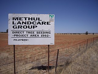
Methul is a locality in the central north part of the Riverina region of south west New South Wales, Australia. It is situated by road, about 14 kilometres (8.7 mi) west of Rannock and 34 kilometres (21 mi) south of Ariah Park.
Tantonan is a rural locality in the central south part of the Riverina, New South Wales, Australia. It is situated by road, about 8 kilometres north west from Caldwell and 13 kilometres south east from Bunnaloo.
Brookdale is a rural locality in the central east part of the Riverina. It is about 8 kilometres, by road, north-west of Bullenbung and 34 kilometres south-east of Galore.

Pulletop is a rural locality in the south eastern part of the Riverina - it used to be called Pullitop. It is situated by road, about 5 kilometres east south-east of Burrandana and 9 kilometres north of Westby.

Corobimilla is a village locality in the central east part of the Riverina. It is situated by road, about 12 kilometres northeast of Morundah and 20 kilometres south west of Narrandera.
Nyora is a rural locality in the central south part of the Riverina and the previous site of a public school. It is situated by road, about 21 kilometres west of Oaklands and 27 kilometres north east of Berrigan.
Moolpa is a small rural community in the southwest part of the Riverina in New South Wales, Australia, and is named after a nearby sheep and wheat station. It is situated about 13 kilometres southwest of Pereketen and 34 kilometres northwest of Moulamein by road.

Baerami is a locality in the Muswellbrook Shire in the Upper Hunter region of New South Wales, Australia.

Ulan is a small village in eastern New South Wales, Australia. Ulan Post Office opened on 1 September 1893.
Marinna is a locality in Junee Shire in southern New South Wales, Australia. Its main feature is a grain silo on the Main South railway line. A station was opened in the locality between 1897 and 1975.
Speewa is a rural locality in the Riverina District of New South Wales, Australia near the Murray River in Murray River Council local government area.
Widden is a locality in New South Wales, Australia, in the Muswellbrook Shire. It is located on the Bylong Valley Way. The Sandy Hollow- Gulgong goods railway line passes through the locality.
Dalcouth is a locality in the Southern Downs Region, Queensland, Australia. It is on the border with New South Wales. In the 2016 census, Dalcouth had a population of 165 people.

