
Badgerys Creek, also known as Badgery's Creek or Aerotropolis, is a suburb of Sydney, in the state of New South Wales, Australia, located approximately 41 kilometres (25 mi) west of the Sydney central business district, in the local government areas of the City of Liverpool. It is part of the Greater Western Sydney region and is adjacent to Kemps Creek, Austral and the Blue Mountains.

The City of Hawkesbury is a local government area of New South Wales, Australia, located on the northern and north-western fringe of the Greater Sydney area, about 50 kilometres (31 mi) north-west of the Sydney central business district. Hawkesbury City is named after the Hawkesbury River. Major suburbs in the City of Hawkesbury are Windsor, Richmond and Pitt Town.
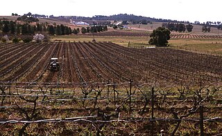
Pokolbin is a rural locality in the Hunter Region of New South Wales Australia. It is part of the Singleton Council local government area and the city of Cessnock. The area is the centre of the Lower Hunter Valley wine region. Pokolbin lies within the Hunter Valley Important Bird Area.
Marlow is a suburb of the Central Coast region of New South Wales, Australia on the north bank of the Hawkesbury River 58 kilometres (36 mi) north of Sydney. It is part of the Central Coast Council local government area.

Mooney Mooney Creek is a suburb of the Central Coast region of New South Wales, Australia, located 60 kilometres (37 mi) north of Sydney along both sides of the river after which it is named. It is part of the Central Coast Council local government area.
Wendoree Park is a Community of the Central Coast region of New South Wales, Australia, located in a remote region on the east bank of Mangrove Creek and on the north bank of the Hawkesbury River 58 kilometres (36 mi) north of Sydney. It is part of the Central Coast Council local government area.
Millbridge is a northeastern suburb of Bunbury, Western Australia, adjoining Eaton 9 km from the centre of Bunbury. At the 2021 census, it had a population of 2,736. Its local government area is the Shire of Dardanup.
Wheeny Creek is a locality of Sydney, in the state of New South Wales, Australia. It is located in the City of Hawkesbury north-east of Kurrajong.
Mogo Creek is a locality within the City of Hawkesbury, in outer metropolitan Sydney, in the state of New South Wales, Australia. It is located south-west of the town of Bucketty. Mangrove Creek Dam is within the locality, and the western half of the locality is within Yengo National Park. Mogo Creek runs adjacent to the locality.

Closeburn is a rural locality in the City of Moreton Bay, Queensland, Australia. In the 2021 census, Closeburn had a population of 562 people.

Bromelton is a rural locality in the Scenic Rim Region, Queensland, Australia. In the 2021 census, the locality of Bromelton had a population of 129 people.
New Auckland is an urban locality in Gladstone in the Gladstone Region, Queensland, Australia. In the 2021 census, New Auckland had a population of 5,266 people.
Canning Creek is a rural locality split between the Goondiwindi Region and the Toowoomba Region in Queensland, Australia. In the 2021 census, Canning Creek had a population of 21 people.

Wrights Creek is a rural locality in the Cairns Region, Queensland, Australia. In the 2021 census, Wrights Creek had a population of 160 people.
Thanes Creek is a rural locality in the Southern Downs Region, Queensland, Australia. In the 2021 census, Thanes Creek had a population of 61 people.

Little Jacks Creek is a locality in the North West Slopes region of New South Wales, Australia. The locality is in the Liverpool Plains Shire local government area, 359 kilometres (223 mi) north west of the state capital, Sydney.
Packers Camp is a rural locality in the Cairns Region, Queensland, Australia. In the 2021 census, Packers Camp had a population of 136 people.
Tuan is a coastal rural town and locality in the Fraser Coast Region, Queensland, Australia. In the 2021 census, the locality of Tuan had a population of 140 people.

Western Creek is a locality in the Toowoomba Region, Queensland, Australia. In the 2021 census, Western Creek had "no people or a very low population".
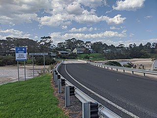
Mossy Point is a suburb in Eurobodalla Shire, New South Wales, Australia. It lies on the Tasman Sea coast to the north of Broulee, separated by Candlagan Creek. It is about 14 km northeast of Moruya and 290 km south of Sydney. At the 2021 census, it had a population of 608.

