
Gregory Blaxland was an English pioneer farmer and explorer in Australia, noted especially for initiating and co-leading the first successful crossing of the Blue Mountains by European settlers.

Ryde is a suburb of Sydney, New South Wales, Australia. Ryde is located 13 km north-west of the Sydney central business district and 8 km east of Parramatta. Ryde is the administrative centre of the local government area of the City of Ryde and part of the Northern Sydney region. It lies on the north bank of the Parramatta River. People from Ryde are colloquially known as Ryders, Rydiens or Rydemen.

Glenbrook is a township of the Lower Blue Mountains of New South Wales, Australia. It is located 63 kilometres west of Sydney in the local government area of the City of Blue Mountains. At the 2016 Australian census Glenbrook had a population of 5,051 people.

The Division of Blaxland is an Australian electoral division in the state of New South Wales.

Blaxland is a town in the Blue Mountains of New South Wales, Australia. Blaxland is located 65 kilometres west of Sydney in the local government area of the City of Blue Mountains. It is at an altitude of 234 metres and borders the townships of Glenbrook, Mount Riverview and Warrimoo.

Newington is a western suburb of Sydney, in the state of New South Wales, Australia. It is 16 kilometres west of the Sydney central business district, in the local government area of City of Parramatta.

Wallacia is a suburb of Sydney, in the state of New South Wales, Australia. Formerly a rural village it is 68 kilometres (42 mi) west of the Sydney GPO, in the local government areas of the City of Penrith, City of Liverpool and Wollondilly Shire. It is part of the Greater Western Sydney region.

Luddenham is a suburb of Sydney, in the state of New South Wales, Australia 42 kilometres west of the Sydney central business district, in the local government areas of the City of Penrith and City of Liverpool. It is part of the Greater Western Sydney region.

Padstow Heights, a suburb of local government area of the City of Canterbury-Bankstown, located 22 kilometres south-west of the Sydney central business district, in the state of New South Wales, Australia. It is a part of the South-western Sydney region. Padstow is a separate suburb to the north and One Tree Point is a locality within Padstow Heights.

Denistone is a suburb in Northern Sydney, in the state of New South Wales, Australia. Denistone is located 16 kilometres north-west of the Sydney central business district in the local government area of the City of Ryde. Denistone West and Denistone East are separate suburbs.

Mount Riverview is a town off the Great Western Highway about 2 km NE of Blaxland in the Lower Blue Mountains, New South Wales, 70 kilometres west of Sydney, Australia. At the 2006 census, Mount Riverview had a population of 2,993 people.
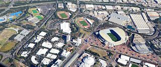
Sydney Olympic Park is a suburb of Greater Western Sydney, located 13 kilometres west of the Sydney central business district, in the local government area of the City of Parramatta Council. It is commonly known as Olympic Park but officially named Sydney Olympic Park. The area was part of the suburb of Lidcombe and known as "North Lidcombe", but between 1989 and 2009 was named "Homebush Bay". The names "Homebush Bay" and, sometimes, "Homebush" are still used colloquially as a metonym for Stadium Australia as well as the Olympic Park precinct as a whole, but Homebush is an older, separate suburb to the southeast, in the Municipality of Strathfield.

Blaxland railway station is located on the Main Western line in New South Wales, Australia. It serves the Blue Mountains suburb of Blaxland opening on 11 July 1867 as Wascoes, being renamed Blaxland on 21 April 1879.
Bowenfels is a small town on the western outskirts of Lithgow, New South Wales, Australia.

Newington House is a historic house in Silverwater, New South Wales, Australia and is located 20 kilometres (12 mi) west of the Sydney central business district, in the local government area of the City of Parramatta. The house and chapel are situated on the southern bank of the Parramatta River and are now enclosed by the Silverwater Correctional Centre. With Elizabeth Bay House and Camden Park, it is considered to be one of the three great houses of the County of Cumberland.
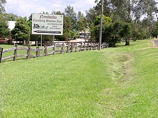
Nymboida is a rural village in the Northern Rivers region of New South Wales, Australia. It is about 21 kilometres south-west of Coutts Crossing, 44 kilometres south-west of Grafton and approximately 687 km north of Sydney. Nymboida is close to the challenging and popular white water rafting waters of the Nymboida River along the Armidale–Grafton Road. The village is in the Clarence Valley Council local government area.

The 1813 crossing of the Blue Mountains was the expedition led by Gregory Blaxland, William Lawson and William Charles Wentworth, which became the first successful crossing of the Blue Mountains in New South Wales by European settlers. The crossing enabled the settlers to access and use the land west of the mountains for farming, and made possible the establishment of Australia's first inland colonial settlement at Bathurst.
Blaxland Creek, a watercourse that is part of the Hawkesbury–Nepean catchment, is located in Greater Western Sydney, Australia.
Blaxland High School is a government-operated comprehensive secondary school located in Blaxland, a suburb in the Blue Mountains region of New South Wales, Australia.
