
Richmond is a town in New South Wales, in the local government area of the City of Hawkesbury. It is located 19 metres above sea level on the alluvial Hawkesbury River flats, at the foot of the Blue Mountains on the Cumberland Plain. It is about 65 km by road from Sydney.

The Colo River, a perennial stream that is part of the Hawkesbury-Nepean catchment, is located in the Central Tablelands of New South Wales, Australia.

Glenbrook is a township of the Lower Blue Mountains of New South Wales, Australia. It is located 63 kilometres west of Sydney in the local government area of the City of Blue Mountains. At the 2016 Australian census Glenbrook had a population of 5,051 people.
The Wollemi Creek, a partly perennial stream of the Hawkesbury-Nepean catchment, is located in the Central Tablelands and Blue Mountains regions of New South Wales, Australia.

The City of Hawkesbury is a local government area of New South Wales, Australia, part of which is at the fringe of the Sydney metropolitan area, about 50 kilometres (31 mi) north-west of the Sydney central business district. Hawkesbury City is named after the Hawkesbury River.

North Richmond is a semi-rural suburb of Richmond, in the state of New South Wales, Australia. North Richmond is located 67 kilometres north-west of the Sydney central business district in the local government area of the City of Hawkesbury. It is separated from Richmond to the south-east by the Hawkesbury River.
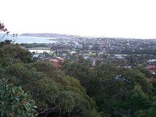
North Curl Curl is a suburb in northern Sydney, in the state of New South Wales, Australia 19 kilometres north-east of the Sydney central business district, in the local government area of Northern Beaches Council. It is part of the Northern Beaches region.

Hawkesbury is an electoral district of the Legislative Assembly in the Australian state of New South Wales. It is represented by Robyn Preston of the Liberal Party.

Waterford West is a suburb in the City of Logan, Queensland, Australia. In the 2016 census, Waterford West had a population of 6,431 people.

Twin Waters is a coastal suburb of Maroochydore in the Sunshine Coast Region, Queensland, Australia. In the 2016 census, Twin Waters had a population of 2,687 people.

Berambing is a rural locality in the Blue Mountains of New South Wales, Australia. The settlement is clustered around the Bells Line of Road, between Windsor and Lithgow, 10 kilometres (6.2 mi) west of Bilpin. It is situated across both the City of Hawkesbury and City of Blue Mountains local government areas. The settlement had a population of 106 people at the 2016 census.

Bell is a small rural and residential village in the Blue Mountains region of New South Wales, Australia. It is the north-westernmost village in the City of Blue Mountains, located approximately 125 kilometres (78 mi) west of Sydney central business district by road or 137 kilometres (85 mi) by rail, approximately 20 kilometres (12 mi) east of Lithgow and 10 kilometres (6.2 mi) north of Mount Victoria. It is a locality on the junction of the Bells Line of Road, Chifley Road and the Darling Causeway, with an elevation of approximately 1,100 metres (3,600 ft) AHD .

Colo Vale is a Northern Village of the Southern Highlands of New South Wales, Australia, in Wingecarribee Shire. Colo Vale is approximately 100 km south west on the Hume Highway from Sydney. It is situated 2 km north-west of Aylmerton, 5 km from the Hume Highway and 12 km drive to Mittagong. At the 2016 census, Colo Vale had a population of 1,618. The surrounding area is part of the Parish of Colo which includes the villages of Aylmerton, Willow Vale, Alpine and Yerrinbool. Colo Vale has a mixed-business general store and many home-based businesses, including hairdressers, small manufacturing businesses and a large native plant nursery and a Public School on Wattle Street. A large sporting oval is located adjacent to the school with tennis courts, a community hall and a Rural Fire Service station.
Central Colo is a locality of Sydney, in the state of New South Wales, Australia. It is located in the City of Hawkesbury west of Colo and to the south of the Colo River near its confluence with the Hawkesbury River.
Upper Colo is a locality of Sydney, in the state of New South Wales, Australia. It is located in the City of Hawkesbury west of Colo and south of Colo Heights, on the Colo River, a tributary of the Hawkesbury River. It was previously known as Colo Upper.

Ebenezer is a rural locality in the City of Ipswich, Queensland, Australia. In the 2016 census Ebenezer had a population of 315 people.

Kents Lagoon is a rural locality in the Scenic Rim Region, Queensland, Australia. In the 2016 census, Kents Lagoon had a population of 56 people.

West Mackay is a suburb of Mackay in the Mackay Region, Queensland, Australia.

Muston is a locality in the Australian state of South Australia located on Kangaroo Island overlooking the coastal lagoon known as Pelican Lagoon about 127 kilometres south-west of the state capital of Adelaide and about 21 kilometres south-east of the municipal seat of Kingscote.
Lagoon Pocket is a rural locality in the Gympie Region, Queensland, Australia. In the 2016 census Lagoon Pocket had a population of 123 people.
