
The Shire of Augusta Margaret River is a local government area in the south-west corner of the South West region of Western Australia, approximately 270 kilometres (168 mi) south of Perth. The shire covers an area of 2,243 square kilometres (866 sq mi) and had a population of over 14,000 at the 2016 Census, about half of whom live in the towns of Margaret River and Augusta.

The Shire of Donnybrook Balingup is a local government area in the South West region of Western Australia, about 35 kilometres (22 mi) southeast of Bunbury and about 220 kilometres (137 mi) south of the state capital, Perth. The Shire covers an area of about 1,560 square kilometres (602 sq mi), and its seat of government is the town of Donnybrook.

The Shire of Halls Creek is one of the four local government areas in the Kimberley region of northern Western Australia, covering an area of 143,030 square kilometres (55,224 sq mi), most of which is sparsely populated. The Shire's seat of government is the town of Halls Creek. Many Aboriginal communities are located within the shire.

The City of Karratha is one of the four local government areas in the Pilbara region of Western Australia. It covers an area of 15,882 square kilometres (6,132 sq mi) and had a population of about 21,500 as at the 2016 Census, most of which is located in its seat of government, the city of Karratha, and the major towns. It was formerly known as the Shire of Roebourne but was renamed and granted city status on 1 July 2014.

The Shire of Mundaring is a local government area in eastern metropolitan Perth, the capital of Western Australia. The Shire covers an area of 645 square kilometres (249 sq mi) and had a population of approximately 38,000 as at the 2016 Census.

The Shire of Kellerberrin is a local government area in the Wheatbelt region of Western Australia, about 60 kilometres (37 mi) west of Merredin and about 200 kilometres (124 mi) east of Perth, the state capital. The Shire covers an area of 1,917 square kilometres (740 sq mi) and its seat of government is the town of Kellerberrin.
The Shire of Carnarvon is a local government area in the Gascoyne region of Western Australia, located about 900 kilometres (560 mi) north of the state capital, Perth. The Shire covers an area of 46,664 square kilometres (18,017 sq mi), and its seat of government is the town of Carnarvon. The major industries in the area are wool, agriculture and, more recently, tourism.
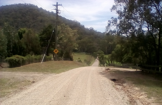
Colo is a small town located north-west of Sydney in New South Wales, Australia. It is home to the Colo River and parts of the Wollemi National Park. The main road through Colo is Putty Road. The locality of Colo is bounded in the south and the east by the Hawkesbury River.
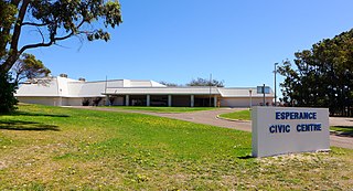
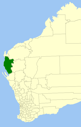
The Shire of Esperance is a local government area in the Goldfields-Esperance region of Western Australia, about 400 kilometres (250 mi) south of the town of Kalgoorlie and about 720 kilometres (450 mi) east-southeast of the state capital, Perth. The Shire covers an area of 42,547 square kilometres (16,427 sq mi), and its seat of government is the town of Esperance, where about three-quarters of the Shire's population resides.
Central Colo is a locality of Sydney, in the state of New South Wales, Australia. It is located in the City of Hawkesbury west of Colo and to the south of the Colo River near its confluence with the Hawkesbury River.
Upper Colo is a locality of Sydney, in the state of New South Wales, Australia. It is located in the City of Hawkesbury west of Colo and south of Colo Heights, on the Colo River, a tributary of the Hawkesbury River. It was previously known as Colo Upper.

Coolana is a rural locality in the Somerset Region, Queensland, Australia. In the 2021 census, Coolana had a population of 175 people.

The City of Greater Geraldton is a local government area in the Mid West region of Western Australia, 424 kilometres (263 mi) north of the state capital, Perth on the Indian Ocean. It covers an area of 12,625.5 square kilometres (4,874.7 sq mi), and its seat of government is the town of Geraldton.
Redbank Creek is a rural locality in the Somerset Region, Queensland, Australia. In the 2021 census, Redbank Creek had a population of 124 people.
Calico Creek is a rural locality in the Gympie Region, Queensland, Australia. In the 2021 census, Calico Creek had a population of 185 people.

Roseneath is an outer suburb of Townsville in the City of Townsville, Queensland, Australia. In the 2021 census, Roseneath had a population of 127 people.
Mount Mackay is a locality in the Cassowary Coast Region, Queensland, Australia. In the 2021 census, Mount Mackay had "no people or a very low population".

Nine Mile is a rural locality in the Rockhampton Region, Queensland, Australia. In the 2021 census, Nine Mile had a population of 84 people.

Gilldora is a rural locality in the Gympie Region, Queensland, Australia. In the 2021 census, Gilldora had a population of 50 people.
Long Flat is a rural locality in the Gympie Region, Queensland, Australia. In the 2021 census, Long Flat had a population of 98 people.
