Wrights Creek Queensland | |||||||||||||||
---|---|---|---|---|---|---|---|---|---|---|---|---|---|---|---|
![]() Looking west along the cane trameway to the Mulgrave Sugar Mill from Hill Road, Wrights Creek, 2018 | |||||||||||||||
Coordinates | 17°01′16″S145°46′26″E / 17.0211°S 145.7738°E | ||||||||||||||
Population | 160 (2021 census) [1] | ||||||||||||||
• Density | 7.05/km2 (18.3/sq mi) | ||||||||||||||
Postcode(s) | 4869 | ||||||||||||||
Area | 22.7 km2 (8.8 sq mi) | ||||||||||||||
Time zone | AEST (UTC+10:00) | ||||||||||||||
Location |
| ||||||||||||||
LGA(s) | Cairns Region | ||||||||||||||
State electorate(s) | Mulgrave | ||||||||||||||
Federal division(s) | |||||||||||||||
|
Wrights Creek is a rural locality in the Cairns Region, Queensland, Australia. [2] In the 2021 census, Wrights Creek had a population of 160 people. [1]
The origin of the suburb name is from the Wright brothers who brought cattle to Wrights Creek in the year 1878. [3]
The locality is mostly low-lying flat land (approx 10 metres above sea level) with a small area of mountainous area in the south-west of the locality rising to an unnamed peak of 200 metres above sea level. The Trinity Inlet (aka Smith Creek) is the northern boundary of the locality while Wrights Creek (the watercourse from which the locality takes its name) and Mackey Creek form parts of the eastern and western boundaries of the locality. Warner Road is the southern boundary. The northern part of the locality is undeveloped wetlands and the mountainous region is also undeveloped. However, apart from these undeveloped areas, the land use is farming (predominantly grwowing sugarcane). [4]
The Bruce Highway and North Coast railway line pass through the south-western part of the locality with Kamma railway station ( 17°03′08″S145°46′08″E / 17.05222°S 145.76889°E ) on the boundary with neighbouring Gordonvale serving the local area. [5] There is also a network of cane tramways to transport the harvested sugarcane to the Mulgrave Sugar Mill. [4] [6]
Wrights Creek is situated in the Yidinji traditional Aboriginal country. [7]
Wright's Creek Provisional School opened on 8 October 1894, becoming Wright's Creek State School on 1 January 1909. It closed in September 1953. [8] [9] It was on the north-eastern side of the railway line south of Harris Road (approx 17°02′25″S45°45′57″E / 17.04016°S 45.76575°E ). [10] [11]
The locality was formerly serviced by now-abandoned Yatee railway station ( 17°02′23″S145°45′42″E / 17.0397°S 145.7618°E ). [12]
In the 2016 census, Wrights Creek had a population of 156 people. [13]
In the 2021 census, Wrights Creek had a population of 160 people. [1]
There are no schools in Wrights Creek. The nearest government primary schools are Hambledon State School in neighbouring Edmonton to the west and Gordonvale State School in neighbouring Gordonvale to the south-east. The nearest government secondary schools are Bentley State College in Bentley Park to the north-west and Gordonvale State High School in Gordonvale. [14]
As part of the Wrights Creek development plan, a trade, enterprise, freight and industry zone has been proposed in the southern part of Wrights Creek nearby Gordonvale to diversify the economy of the Cairns region and to provide employment opportunities. The development plan utilises the location of the Bruce Highway and North Coast railway line transport corridors. Significant portions of land would be retained for the purpose of sugarcane farming in the area and environmental management purposes. [15] The local council supported the state development area on the basis that existing private businesses in the region would not be impacted by competition. [16]
As part of the Bruce Highway Southern Access Corridor development project, the construction of an off-road cycling path and an upgrade of the Bruce Highway has been funded by the state and federal governments, with construction expected to be completed from 2021–2023. [17] [18]
Gordonvale is a rural sugar-growing town and locality situated on the southern side of Cairns in the Cairns Region, Queensland, Australia. In the 2021 census, the locality of Gordonvale had a population of 6,944 people.
Edmonton is a town and suburb in the Cairns Region, Queensland, Australia. In the 2021 census, the suburb of Edmonton had a population of 11,409 people.
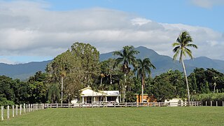
Aloomba is a rural town and a locality in the Cairns Region, Queensland, Australia. In the 2021 census, the locality of Aloomba had a population of 576 people.
Mirriwinni is a rural town and locality in the Cairns Region, Queensland, Australia. The spelling Miriwinni has also been used historically, but Mirriwinni is the official spelling from 8 October 2010. In the 2021 census, the locality of Mirriwinni had a population of 492 people.
Woopen Creek is a rural locality in the Cairns Region, Queensland, Australia. In the 2021 census, Woopen Creek had a population of 135 people.
Clairview is a coastal town and locality in the Isaac Region, Queensland, Australia. In the 2021 census, the locality of Clairview had a population of 167 people.
Kennedy is a coastal locality in the Cassowary Coast Region, Queensland, Australia. In the 2021 census, Kennedy had a population of 136 people.
Deeral is a town and coastal locality in the Cairns Region, Queensland, Australia. In the 2021 census, the locality of Deeral had a population of 151 people.
Feluga is a rural locality in the Cassowary Coast Region, Queensland, Australia. In the 2021 census, Feluga had a population of 306 people.
Fishery Falls is a locality in the Cairns Region, Queensland, Australia. In the 2021 census, Fishery Falls had a population of 205 people.
Mount Peter is a rural locality in the Cairns Region, Queensland, Australia. In the 2021 census, Mount Peter had a population of 689 people.
Eubenangee is a coastal locality split between the Cairns Region and the Cassowary Coast Region, Queensland, Australia. In the 2021 census, Eubenangee had a population of 247 people.
Euramo is a rural locality in the Cassowary Coast Region, Queensland, Australia. In the 2021 census, Euramo had a population of 114 people.
Barron is a suburb of Cairns in the Cairns Region, Queensland, Australia. In the 2021 census, Barron had a population of 68 people.
Glen Boughton is a rural locality in the Cairns Region, Queensland, Australia. In the 2021 census, Glen Boughton had a population of 19 people.
Goldsborough is a locality in the Cairns Region, Queensland, Australia. In the 2021 census, Goldsborough had a population of 1,099 people.
Packers Camp is a rural locality in the Cairns Region, Queensland, Australia. In the 2021 census, Packers Camp had a population of 136 people.
Green Hill is a rural locality in the Cairns Region, Queensland, Australia. In the 2021 census, Green Hill had a population of 177 people.
Waugh Pocket is a locality in the Cairns Region, Queensland, Australia. In the 2021 census, Waugh Pocket had a population of 46 people.
Djarawong is a rural locality in the Cassowary Coast Region, Queensland, Australia. In the 2021 census, Djarawong had a population of 103 people.
Media related to Wrights Creek, Queensland at Wikimedia Commons