Lamb Range

Last updated

Lamb Range
Queensland
Lake Morris Road - panoramio.jpg
Waterfall near Copperlode Falls Dam, 2008
Australia Queensland location map.svg
Red pog.svg
Lamb Range
Coordinates 17°02′52″S145°41′19″E / 17.0477°S 145.6886°E / -17.0477; 145.6886
Population0 (2021 census) [1]
 • Density0.0000/km2 (0.000/sq mi)
Postcode(s) 4870
Area229.5 km2 (88.6 sq mi)
LGA(s) Cairns Region
State electorate(s)
Federal division(s)
Suburbs around Lamb Range:
Speewah
Koah
Barron Gorge
Redlynch
Kanimbla
Mooroobool
Earlville
Bayview Heights
Mareeba Lamb Range Mount Sheridan
Bentley Park
Edmonton
Mount Peter
Danbulla Gadgarra
Goldsborough
Gordonvale
Little Mulgrave

Lamb Range is a locality in the Cairns Region, Queensland, Australia. [2] In the 2021 census, Lamb Range had "no people or a very low population". [1]

Contents

Geography

The locality takes its name from the mountain range Lamb Range. [3]

The locality that lies to the west of most of the southern suburbs of Cairns. It is undeveloped mountainous land rising from the coastal plains (elevation of less than 50 metres above sea level) up through the Great Dividing Range (with elevations up to 1200 metres) towards the Atherton Tableland. The land use is entirely committed to national parks and reserves. Dinden National Park and Lake Morris Reserve are in the north of the locality with Little Mulgrave National Park in the south. A small area in the west is in the Danbulla National Park. [4]

There is only one road through the locality. The Gillies Range Road (also known as the Gillies Highway) passes through the south of the locality connecting Gordonvale in the Cairns Region with Atherton in the Tablelands Region. Lake Morris Road commences in Kanimbla and passes through Mooroobool and then travels through Lamb Range to Lake Morris but does not extend beyond the dam. [4]

Demographics

In the 2016 census, Lamb Range had "no people or a very low population". [5]

In the 2021 census, Lamb Range had "no people or a very low population". [1]

Attractions

View from the Gillies Lookout off the Gillies Highway, 2011 Gillies Lookout - panoramio.jpg
View from the Gillies Lookout off the Gillies Highway, 2011

The Gillies Range Road is a 19 kilometres (12 mi) long road which ranges from an elevation of 20 metres to 820 metres. The road is winding with 263 corners and has a number of lookouts. [6]

Related Research Articles

<span class="mw-page-title-main">Yungaburra</span> Town in Queensland, Australia

Yungaburra is a rural town and locality in the Tablelands Region, Queensland, Australia. In the 2016 census, the locality of Yungaburra had a population of 1,239 people.

<span class="mw-page-title-main">Gordonvale, Queensland</span> Suburb of Cairns, Queensland, Australia

Gordonvale is a rural sugar-growing town and locality situated on the southern side of Cairns in the Cairns Region, Queensland, Australia. In the 2021 census, the locality of Gordonvale had a population of 6,944 people.

<span class="mw-page-title-main">Atherton Tableland</span> Fertile plateau in northern Queensland, Australia

The Atherton Tableland is a fertile plateau, which is part of the Great Dividing Range in Queensland, Australia. It has very deep, rich basaltic soils and the main industry is agriculture. The principal river flowing across the plateau is the Barron River, which was dammed to form the irrigation reservoir named Lake Tinaroo. Unlike many other rural areas, the Tablelands is experiencing a significant growth in population.

<span class="mw-page-title-main">Atherton, Queensland</span> Town in Queensland, Australia

Atherton is a rural town and locality in the Tablelands Region, Queensland, Australia. In the 2016 census, Atherton had a population of 7,331 people.

<span class="mw-page-title-main">Kuranda, Queensland</span> Town in Queensland, Australia

Kuranda is a rural town and locality on the Atherton Tableland in the Shire of Mareeba, Queensland, Australia. In the 2016 census, Kuranda had a population of 3,008 people. It is 25 kilometres (16 mi) from Cairns, via the Kuranda Range road. It is surrounded by tropical rainforest and adjacent to the Wet Tropics of Queensland World Heritage listed Barron Gorge National Park.

<span class="mw-page-title-main">Barron River (Queensland)</span> River in Queensland, Australia

The Barron River is located on the Atherton Tablelands inland from Cairns in North Queensland, Australia. With its headwaters below Mount Hypipamee, the 165-kilometre (103 mi)-long river with a catchment area of approximately 2,138 square kilometres (825 sq mi) forms through run off from the Mount Hypipamee National Park, flows through Lake Tinaroo, and eventually empties into the Coral Sea between Machans Beach and Aeroglen.

<span class="mw-page-title-main">Malanda, Queensland</span> Town in Queensland, Australia

Malanda is a rural town and locality in the Tablelands Region, Queensland, Australia. In the 2016 census, the locality of Malanda had a population of 1,985 people. The economy is based upon agriculture and tourism.

<span class="mw-page-title-main">Kairi, Queensland</span> Town in Queensland, Australia

Kairi is a rural town and locality in the Tablelands Region, Queensland, Australia. In the 2016 census, Kairi had a population of 442 people.

<span class="mw-page-title-main">Gillies Highway</span>

The Gillies Highway is a road that runs from Gordonvale in the Cairns Region through the Gillies Range to Atherton in the Tablelands Region, both in Queensland, Australia. Its official name is Gillies Range Road, and it was originally known as the Cairns Range Road.

Wondecla is a rural locality in the Tablelands Region, Queensland, Australia. In the 2016 census Wondecla had a population of 638 people.

<span class="mw-page-title-main">Little Mulgrave, Queensland</span> Suburb of Cairns Region, Queensland, Australia

Little Mulgrave is a locality in the Cairns Region, Queensland, Australia. In the 2021 census, Little Mulgrave had a population of 269 people.

<span class="mw-page-title-main">Gadgarra</span> Suburb of Tablelands Region, Queensland, Australia

Gadgarra is a rural locality in the Tablelands Region, Queensland, Australia. In the 2021 census, Gadgarra had "no people or a very low population".

<span class="mw-page-title-main">Lake Barrine, Queensland</span> Suburb of Tablelands Region, Queensland, Australia

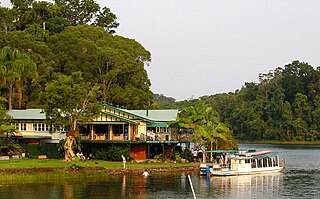
Lake Barrine is a rural locality in the Tablelands Region, Queensland, Australia. In the 2021 census, Lake Barrine had a population of 170 people.

Tumoulin is a rural town and locality in the Tablelands Region, Queensland, Australia. In the 2016 census, Tumoulin had a population of 109 people.

<span class="mw-page-title-main">Upper Barron</span> Suburb of Tablelands Region, Queensland, Australia

Upper Barron is a rural locality in the Tablelands Region, Queensland, Australia. In the 2021 census, Upper Barron had a population of 503 people.

<span class="mw-page-title-main">Barron Gorge, Queensland</span> Suburb of Cairns Region, Queensland, Australia

Barron Gorge is a rural locality in the Cairns Region, Queensland, Australia. In the 2021 census, Barron Gorge had "no people or a very low population".

<span class="mw-page-title-main">Goldsborough, Queensland</span> Suburb of Cairns Region, Queensland, Australia

Goldsborough is a locality in the Cairns Region, Queensland, Australia. In the 2021 census, Goldsborough had a population of 1,099 people.

<span class="mw-page-title-main">Macalister Range, Queensland</span> Suburb of Cairns Region, Queensland, Australia

Macalister Range is a coastal locality in the Cairns Region, Queensland, Australia. In the 2021 census, Macalister Range had "no people or a very low population".

<span class="mw-page-title-main">Danbulla, Queensland</span> Suburb of Tablelands Region, Queensland, Australia

Danbulla is a locality in the Tablelands Region, Queensland, Australia. In the 2021 census, Danbulla had a population of 88 people.

<span class="mw-page-title-main">Middlebrook, Queensland</span> Suburb of Tablelands Region, Queensland, Australia

Middlebrook is a rural locality in the Tablelands Region, Queensland, Australia. In the 2021 census, Middlebrook had a population of 62 people.

References

  1. 1 2 3 Australian Bureau of Statistics (28 June 2022). "Lamb Range (SAL)". 2021 Census QuickStats. Retrieved 28 February 2023. OOjs UI icon edit-ltr-progressive.svg
  2. "Lamb Range – locality in Cairns Region (entry 48724)". Queensland Place Names. Queensland Government . Retrieved 29 December 2017.
  3. "Lamb Range – range in the Tablelands Region (entry 18847)". Queensland Place Names. Queensland Government . Retrieved 18 March 2018.
  4. 1 2 "Queensland Globe". State of Queensland . Retrieved 18 March 2018.
  5. Australian Bureau of Statistics (27 June 2017). "Lamb Range (SSC)". 2016 Census QuickStats. Retrieved 20 October 2018. OOjs UI icon edit-ltr-progressive.svg
  6. "Atherton Tablelands: From Cairns". Tropical Tablelands Tourism. Archived from the original on 18 March 2018. Retrieved 19 March 2018.

Commons-logo.svg Media related to Lamb Range, Queensland at Wikimedia Commons