Clifton Beach, Queensland

Last updated

Clifton Beach
Cairns,  Queensland
Clifton-beach.JPG
Clifton Beach, 2013
Clifton Beach (Qld) - Map 1.jpg
Clifton Beach (Qld) - Map 2.jpg
Map of Clifton Beach in the Cairns Region
Australia Queensland relief location map.jpg
Red pog.svg
Clifton Beach
Clifton Beach, Queensland
Coordinates 16°45′58.6″S145°40′13.2″E / 16.766278°S 145.670333°E / -16.766278; 145.670333 (Clifton Beach (centre of suburb))
Population3,192 (2021 census) [1]
 • Density414.5/km2 (1,074/sq mi)
Postcode(s) 4879
Area7.7 km2 (3.0 sq mi)
Time zone AEST (UTC+10:00)
Location
LGA(s) Cairns Region
State electorate(s) Barron River
Federal division(s) Leichhardt
Suburbs around Clifton Beach:
Macalister Range Palm Cove Coral Sea
Macalister Range Clifton Beach Coral Sea
Macalister Range Kewarra Beach Coral Sea

Clifton Beach is a coastal suburb in the Cairns Region, Queensland, Australia. [2] In the 2021 census, Clifton Beach had a population of 3,192 people.

Contents

Geography

Clifton Beach is located about 22 kilometres north of the city centre of Cairns on the Coral Sea. To the west, the mountains of the Macallister Range form the border with the Kuranda State Forest (→ Kuranda). The suburb of Kewarra Beach lies to the south and Palm Cove to the north. The Captain Cook Highway runs through the suburb.

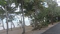
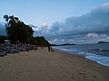
To the east, the suburb is bordered by a long sandy beach. The beach, which is affected by erosion, is not very wide, especially in the south, and is almost completely submerged at high tide. Rocky groynes protect it against erosion damage. It is only suitable for bathing to a limited extent, as it is often visited by crocodiles. In the first half of the calendar year, so-called "stinger" jellyfish also appear. Contact with their tentacles typically causes considerable pain and occasionally even danger to life. In the north of the beach there is a bathing facility protected by nets, which also offers sufficient protection from crocodiles. There are also some barbecue areas.

History

Clifton Beach is situated in the Djabugay (Tjapukai) traditional Aboriginal country. [3]

Sugar cane farmer William Fairweather laid out an access road to his farm. The Mulgrave Shire Council at the time named the area after the birthplace of his wife, who was from Clifton in the Darling Downs of southern Queensland. [4] Alternatively, it is believed that the suburb was named after Clifton in Perthshire, Scotland, the birthplace of Mary Hunter Smart, a settler around 1880. [5] [6]

Clifton Beach was officially declared a suburb on 2 May 1959.[ citation needed ] In 1969, a post office was opened. In the 1970s, construction and road improvements began. By the 1980s, there were three trailer parks and a jellyfish-safe swimming facility. Clifton Beach was a mixture of residential and holiday resort with a rural atmosphere.

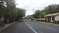
There are older houses and tourist facilities from this period on Arlington Esplanade running along the beach. A community centre was built a short distance back from the esplanade and local shops sold everyday goods, arts, and crafts. The Wild World Zoo, later called the Cairns Tropical Zoo, opened on the Captain Cook Highway and attracted traffic.

In the second half of the 1980s, the population increased by about two-thirds.[ citation needed ] Growth continued into the 2000s. A middle to upper class suburb emerged with many retirees. The area between the highway and the beach was almost entirely built up, while the other side of the highway, which borders the Kuranda State Forest and accounts for about two-thirds of Clifton Beach, remained largely undeveloped.

A shopping centre was built on Captain Cook Highway. A 2004 expansion added a supermarket operated by the national Coles chain.[ citation needed ] The nearest major shopping centre is about halfway to Cairns city in Smithfield.

Amenities

There are no schools or the like in Clifton Beach. The post office is in the shopping centre, the Clifton Village Shopping Centre on Captain Cook Highway, which is accessible via Endeavour Road and where you will also find doctors, a few other shops for local needs and restaurants. There is some accommodations for tourists. In the centre, there is a bar and grill restaurant. It "does a roaring trade of breakfast cocktails because locals struggle with the crushing weight of reality and like to be legless by noon". [7]

There are a number of parks in the suburb, including:

Images

Related Research Articles

<span class="mw-page-title-main">Fitzroy Island National Park</span> Protected area in Queensland, Australia

Fitzroy Island National Park is a gazetted protected area covering Fitzroy Island, in Far North Queensland, Queensland, Australia. Fitzroy Island, is a continental island located 22 kilometres (14 mi) east of Cairns on the mainland.

<span class="mw-page-title-main">Cairns</span> City in Queensland, Australia

Cairns is a city in Queensland, Australia, on the tropical north east coast of Far North Queensland. In the 2021 census, Cairns had a population of 153,181 people.

<span class="mw-page-title-main">Captain Cook Highway</span>

The Captain Cook Highway is a short, regional highway in Queensland which originates in Cairns and terminates in Mossman, where it joins Mossman-Daintree Road, continuing to Daintree. It is a state-controlled regional road.

<span class="mw-page-title-main">Kuranda, Queensland</span> Town in Queensland, Australia

Kuranda is a rural town and locality on the Atherton Tableland in the Shire of Mareeba, Queensland, Australia. In the 2016 census, Kuranda had a population of 3,008 people. It is 25 kilometres (16 mi) from Cairns, via the Kuranda Range road. It is surrounded by tropical rainforest and adjacent to the Wet Tropics of Queensland World Heritage listed Barron Gorge National Park.

<span class="mw-page-title-main">Barron River (Queensland)</span> River in Queensland, Australia

The Barron River is located on the Atherton Tablelands inland from Cairns in North Queensland, Australia. With its headwaters below Mount Hypipamee, the 165-kilometre (103 mi)-long river with a catchment area of approximately 2,138 square kilometres (825 sq mi) forms through run off from the Mount Hypipamee National Park, flows through Lake Tinaroo, and eventually empties into the Coral Sea between Machans Beach and Aeroglen.

<span class="mw-page-title-main">Ellis Beach, Queensland</span> Suburb of Cairns Region, Queensland, Australia

Ellis Beach is a coastal locality in the Cairns Region, Queensland, Australia. In the 2021 census, Ellis Beach had a population of 5 people.

<span class="mw-page-title-main">Kuranda Scenic Railway</span>

The Kuranda Scenic Railway is a tourist railway service that operates along the heritage-listed Cairns-to-Kuranda railway line. Constructed in 1891, the line runs from Cairns, Queensland, over the Great Dividing Range to the town of Kuranda on the Atherton Tableland. Along the way, the route passes through the Macalister Range, as well as the suburbs of Stratford, Freshwater and Redlynch. The train also stops at a lookout, which provides views of Barron Falls.

The history of Cairns in Queensland, Australia, is a transition of a port from a shanty town to a modern city, following an uncertain start because of competition from the newly created neighbouring community of Port Douglas. A succession of major work projects, institution establishments and direct involvement in world enterprise accelerated the settlement's development.

<span class="mw-page-title-main">Smithfield, Queensland</span> Suburb of Cairns, Queensland, Australia

Smithfield is a suburb of Cairns in the Cairns Region, Queensland, Australia. In the 2021 census Smithfield had a population of 6,664 people.

<span class="mw-page-title-main">Yorkeys Knob, Queensland</span> Suburb of Cairns, Queensland, Australia

Yorkeys Knob is a coastal suburb of Cairns in the Cairns Region, Queensland, Australia. In the 2016 census, Yorkeys Knob had a population of 2,759 people.

<span class="mw-page-title-main">Palm Cove, Queensland</span> Suburb of Cairns, Queensland, Australia

Palm Cove is a suburb of Cairns in the Cairns Region, Queensland, Australia. In the 2016 census, Palm Cove had a population of 2,059 people.

<span class="mw-page-title-main">Holloways Beach, Queensland</span> Suburb of Cairns, Queensland, Australia

Holloways Beach is a residential coastal suburb of Cairns, Queensland, Australia. In the 2021 census, Holloways Beach had a population of 2,398 people. II is located about 10 kilometres north of the city of Cairns between the suburbs of Machans Beach and Yorkeys Knob.

<span class="mw-page-title-main">Aeroglen</span> Suburb of Cairns, Queensland, Australia

Aeroglen is a coastal suburb of Cairns in the Cairns Region, Queensland, Australia. In the 2016 census, Aeroglen had a population of 403 people.

<span class="mw-page-title-main">Cairns railway station</span> Railway station in Queensland, Australia

Cairns railway station is a railway station in Cairns City, Queensland, Australia, serving the city of Cairns. The stations is the terminus of the North Coast line from Brisbane and the terminus for the Tablelands railway line to the Atherton Tableland. Two tourist railway services operate from here: the Kuranda Scenic Railway and the Savannahlander. The station has two platforms. It is integrated with the Cairns Central Shopping Centre, with the platforms being built underneath parking areas.

<span class="mw-page-title-main">Kewarra Beach</span> Suburb of Cairns, Queensland, Australia

Kewarra Beach is a coastal suburb of Cairns in the Cairns Region, Queensland, Australia. In the 2016 census, Kewarra Beach had a population of 5,652 people.

<span class="mw-page-title-main">Bungalow, Queensland</span> Suburb of Cairns, Queensland, Australia

Bungalow is an inner suburb of Cairns in the Cairns Region, Queensland, Australia. In the 2016 census Bungalow had a population of 2,159 people.

<span class="mw-page-title-main">Machans Beach, Queensland</span> Suburb of Cairns, Queensland, Australia

Machans Beach is a beach and coastal suburb of Cairns in the Cairns Region, Queensland, Australia. In the 2021 census, Machans Beach had a population of 943 people.

<span class="mw-page-title-main">Barron, Queensland</span> Suburb of Cairns, Queensland, Australia

Barron is a suburb of Cairns in the Cairns Region, Queensland, Australia. In the 2016 census Barron had a population of 42 people.

<span class="mw-page-title-main">Macalister Range, Queensland</span> Suburb of Cairns Region, Queensland, Australia

Macalister Range is a coastal locality in the Cairns Region, Queensland, Australia. In the 2021 census, Macalister Range had a population of 0 people.

References

  1. Clifton Beach (L) 2021 Census All persons QuickStats
  2. "Clifton Beach – suburb in Cairns Region (entry 48571)". Queensland Place Names. Queensland Government . Retrieved 6 March 2022.
  3. "First people cultural history". Cairns Regional Council. Archived from the original on 21 April 2017. Retrieved 23 June 2020.
  4. s. Queensland Places, University of Queensland
  5. s. Queensland place names search
  6. "Clifton, Perthshire" (Historical Description), UK Genealogy Archives (per March 2023)
  7. "Cairns suburbs guide: Chris Calcino’s brutal take on your city", Cairns Post, 15 March 2021
  8. 1 2 "Land for public recreation - Queensland". Queensland Open Data. Queensland Government. 20 November 2020. Archived from the original on 22 November 2020. Retrieved 22 November 2020.

Commons-logo.svg Media related to Clifton Beach, Queensland at Wikimedia Commons