Machans Beach, Queensland

Last updated

Machans Beach
Cairns,  Queensland
Cairns001.jpg
Esplanade 2005
Australia Queensland location map.svg
Red pog.svg
Machans Beach
Machans Beach, Queensland
Coordinates 16°51′20″S145°44′52″E / 16.8555°S 145.7477°E / -16.8555; 145.7477 (Machans Beach (centre of suburb))
Population943 (SAL 2021) [1]
Established1885
Postcode(s) 4878
Area7.1 km2 (2.7 sq mi)
Time zone AEST (UTC+10:00)
Location
LGA(s) Cairns Region
State electorate(s) Barron River
Federal division(s) Leichhardt
Suburbs around Machans Beach:
Holloways Beach Coral Sea. Coral Sea
Barron Machans Beach Coral Sea
Stratford Aeroglen Aeroglen

Machans Beach is a beach and coastal suburb of Cairns in the Cairns Region, Queensland, Australia. [2] [3] In the 2021 census, Machans Beach had a population of 943 people. [4]

Contents

Geography

Gundy Anton Bridge from Machans Beach over Redden Creek to Redden Island, 2018 Gundy Anton Bridge over Redden Creek to Redden Island, Machans Beach, 2018.jpg
Gundy Anton Bridge from Machans Beach over Redden Creek to Redden Island, 2018

The Barron River and Barr Creek are respectively the southern and northern boundaries of the suburb, while the Coral Sea and Captain Cook Highway form the eastern and western boundaries. [5]

Looking upstream on Redden Creek (offshoot of the Barron River), 2018 Looking upstream of Redden Creek (off shoot of Barron River) from Gundy Anton Bridge, Machans Beach, 2018 02.jpg
Looking upstream on Redden Creek (offshoot of the Barron River), 2018

The land is flat and just above sea level. The residential development is in the east of the suburb near the coast. The north-eastern coastline is a rocky sea wall, but the south-eastern coastline has a sand beach with the two sections separated by Redden Creek, which flows from the Barron River as a second mouth on the Coral Sea, creating an area known as Redden Island. [5] The Gundy Anton Bridge crosses Redden Creek to connect the mainland part of Machans Beach with Redden Island. [6]

Redden Island is an important habit and feeding ground for shorebirds with over 100 species of bird being recorded there, including some rare and endangered species such as the eastern curlew, the great knot, the curlew sandpiper, the bar-tailed godwit, the red knot, and the lesser sand plover. These migratory shorebirds travel up to 25,000 km each year on their migration between Australian and Asia, some travelling as far north as Siberia and Japan. [7]

The majority of the suburb is still used as freehold farming land with sugarcane the predominant crop. [5]

History

Looking south along the esplanade, 2018 Looking south along the esplanade, Machans Beach, 2018 01.jpg
Looking south along the esplanade, 2018

The Yirrganydji people (Tjapukai) traditionally inhabited the area. They used dugouts (single outrigger canoes) for fishing. From the canoes they used spears to catch smaller fish and harpoons to catch large sea creatures such as dugong and turtle. In sheltered creeks, the Yirrganydji people established fish traps, fences of lawyer vine and bushes spread across the creek held in position in the creek by a series of stakes. The women would drive the fish into the traps by beating on the water. Some men pulled on the sides of the fish trap to hold it tight while other men speared the fish driven into the trap. According to traditional lore, if a sea snake was caught, it had to be released or else there would be huge storms. [8]

Older homes, 2018 Machans beach Cairns qld au 01.jpg
Older homes, 2018

The area was first surveyed in 1885, but was not permanently settled until the 1920s. It is named after Richard Machan who was among the first permanent white settlers in the area, having purchased land in the 1920s. Using a Model T Ford, Richard Machan provided transportation services to the area. He built a jetty to encourage tourist boats from Cairns to call at nearby Barron Beach. [9] [10]

New homes on Redden Island, 2018 Looking from Anton Gundy Bridge south-east along Marshall Street, Machans Beach, 2018.jpg
New homes on Redden Island, 2018

Machans Beach State School opened on 4 February 1952. [11]

In 1961, Gundy Anton donated part of his land for use in constructing a bridge across Redden Creek to Redden Island. In 2006, the council approved a local community proposal that the bridge (then known as the Redden Island Bridge) be renamed the Gundy Anton Bridge to reflect both the donation of the land and the considerable community service performed by Anton over the years. [6]

Machans Beach was gazetted as a suburb in 2002, having previously been a locality. [2]

Machans Beach is located about 1 to 2 kilometres (0.62 to 1.24 mi) north of the Cairns International Airport. Plans to extend the airport in 2011 raised a number of objections from Machans Beach residents in relation to environmental concerns and noise concerns. [12]

Looking south along the sea wall, 2018 Looking south along the sea wall at Machans Beach, 2018.jpg
Looking south along the sea wall, 2018

The coastline and waterways in the area are unstable due to storm surge and flooding, which have changed the course of the Barron River over the years. From April 2014 to August 2015, the crumbling seawall along the suburb's northern coastline was rebuilt combined with the construction of a causeway further out to sea to provide greater protection for the growing number of residences along the coastal area following a number of severe storms. The project cost the Cairns Regional Council $16.8M. [13] [14] [15] [16] The drawback of the seawall is that it prevents a sandy beach from forming. [17]

Demographics

In the 2011 census, Machans Beach had a population of 941 people. [18]

In the 2016 census, Machans Beach had a population of 1,051 people. [19]

In the 2021 census, Machans Beach had a population of 943 people. [4]

Education

Machans Beach State School, 2023 Machans Beach State School, 2023 01.jpg
Machans Beach State School, 2023

Machans Beach State School is a government primary (Prep-6) school for boys and girls at 61 Machan Street ( 16°51′09″S145°44′42″E / 16.8526°S 145.7449°E / -16.8526; 145.7449 (Machans Beach State School) ). [20] [21] In 2018, the school had an enrolment of 116 students with 10 teachers (8 full-time equivalent) and 8 non-teaching staff (4 full-time equivalent). [22]

There are no secondary schools in Machans Beach. The nearest government secondary school is Cairns State High School in Cairns North to the south. [23]

Related Research Articles

<span class="mw-page-title-main">Cairns</span> City in Queensland, Australia

Cairns is a city in Queensland, Australia, on the tropical north east coast of Far North Queensland. In the 2021 census, Cairns had a population of 153,181 people.

<span class="mw-page-title-main">Barron River (Queensland)</span> River in Queensland, Australia

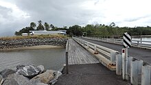
The Barron River is located on the Atherton Tablelands inland from Cairns in North Queensland, Australia. With its headwaters below Mount Hypipamee, the 165-kilometre (103 mi)-long river with a catchment area of approximately 2,138 square kilometres (825 sq mi) forms through run off from the Mount Hypipamee National Park, flows through Lake Tinaroo, and eventually empties into the Coral Sea between Machans Beach and Aeroglen.

<span class="mw-page-title-main">Ellis Beach, Queensland</span> Suburb of Cairns Region, Queensland, Australia

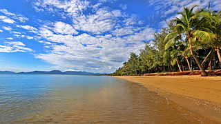
Ellis Beach is a coastal locality in the Cairns Region, Queensland, Australia. In the 2021 census, Ellis Beach had a population of 5 people.

<span class="mw-page-title-main">Yorkeys Knob, Queensland</span> Suburb of Cairns, Queensland, Australia

Yorkeys Knob is a coastal suburb of Cairns in the Cairns Region, Queensland, Australia. In the 2016 census, Yorkeys Knob had a population of 2,759 people.

<span class="mw-page-title-main">Holloways Beach, Queensland</span> Suburb of Cairns, Queensland, Australia

Holloways Beach is a residential coastal suburb of Cairns, Queensland, Australia. In the 2021 census, Holloways Beach had a population of 2,398 people. II is located about 10 kilometres north of the city of Cairns between the suburbs of Machans Beach and Yorkeys Knob.

<span class="mw-page-title-main">Freshwater, Queensland</span> Suburb of Cairns, Queensland, Australia

Freshwater is a suburb of Cairns, Queensland, Australia. In the 2016 census, Freshwater had a population of 2,023 people.

<span class="mw-page-title-main">Stratford, Queensland</span> Suburb of Cairns, Queensland, Australia

Stratford is a suburb of Cairns in the Cairns Region, Queensland, Australia. In the 2016 census, Stratford had a population of 1,138 people.

<span class="mw-page-title-main">Aeroglen</span> Suburb of Cairns, Queensland, Australia

Aeroglen is a coastal suburb of Cairns in the Cairns Region, Queensland, Australia. In the 2016 census, Aeroglen had a population of 403 people.

<span class="mw-page-title-main">Caravonica, Queensland</span> Suburb of Cairns, Queensland, Australia

Caravonica is a suburb of Cairns in the Cairns Region, Queensland, Australia. In the 2016 census, Caravonica had a population of 1,989 people.

<span class="mw-page-title-main">Trinity Beach, Queensland</span> Suburb of Cairns, Queensland, Australia

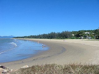
Trinity Beach is a coastal suburb of Cairns in the Cairns Region, Queensland, Australia. In the 2021 census, Trinity Beach had a population of 6,594 people.

<span class="mw-page-title-main">Balgal Beach, Queensland</span> Suburb of Townsville, Queensland, Australia

Balgal Beach is a coastal suburb and a beach in the City of Townsville, Queensland, Australia. The town of Balgal is within the locality. In the 2021 census, Balgal Beach had a population of 998 people.

<span class="mw-page-title-main">Kamerunga, Queensland</span> Suburb of Cairns, Queensland, Australia

Kamerunga is a suburb of Cairns in the Cairns Region, Queensland, Australia. In the 2016 census, Kamerunga had a population of 1,049 people.

<span class="mw-page-title-main">Redlynch, Queensland</span> Suburb of Cairns, Queensland, Australia

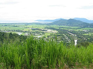
Redlynch is a semi-rural town and suburb of Cairns in the Cairns Region, Queensland, Australia. In the 2016 census, the suburb of Redlynch had a population of 9,728 people.

Paget is a coastal suburb of Mackay in the Mackay Region, Queensland, Australia. In the 2016 census, Paget had a population of 273 people.

<span class="mw-page-title-main">White Rock, Queensland (Cairns Region)</span> Suburb of Cairns, Queensland, Australia

White Rock is a suburb of Cairns in the Cairns Region, Queensland, Australia. In the 2016 census, White Rock had a population of 4,730 people.

East Mackay is a coastal suburb of Mackay in the Mackay Region, Queensland, Australia. In the 2016 census, East Mackay had a population of 3,564 people.

<span class="mw-page-title-main">Barron, Queensland</span> Suburb of Cairns, Queensland, Australia

Barron is a suburb of Cairns in the Cairns Region, Queensland, Australia. In the 2016 census Barron had a population of 42 people.

<span class="mw-page-title-main">Portsmith</span> Suburb of Cairns, Queensland, Australia

Portsmith is a suburb of Cairns in the Cairns Region, Queensland, Australia. In the 2021 census, Portsmith had a population of 314 people.

<span class="mw-page-title-main">Trinity Park, Queensland</span> Suburb of Cairns, Queensland, Australia

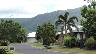
Trinity Park is a coastal suburb of Cairns in the Cairns Region, Queensland, Australia. In the 2021 census, Trinity Park had a population of 3,536 people.

<span class="mw-page-title-main">Macalister Range, Queensland</span> Suburb of Cairns Region, Queensland, Australia

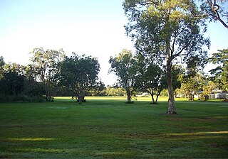
Macalister Range is a coastal locality in the Cairns Region, Queensland, Australia. In the 2021 census, Macalister Range had a population of 0 people.

References

  1. Australian Bureau of Statistics (28 June 2022). "Machans Beach (suburb and locality)". Australian Census 2021 QuickStats. Retrieved 28 June 2022.  OOjs UI icon edit-ltr-progressive.svg
  2. 1 2 "Machans Beach – suburb in Cairns Region (entry 48738)". Queensland Place Names. Queensland Government . Retrieved 28 September 2017.
  3. "Machans Beach – beach in Cairns Region (entry 41948)". Queensland Place Names. Queensland Government . Retrieved 28 September 2017.
  4. 1 2 Australian Bureau of Statistics (28 June 2022). "Machans Beach (SAL)". 2021 Census QuickStats. Retrieved 28 February 2023. OOjs UI icon edit-ltr-progressive.svg
  5. 1 2 3 "Queensland Globe". State of Queensland . Retrieved 28 April 2018.
  6. 1 2 "Meeting: Works & Services Committee" (PDF). Cairns City Council. 16 May 2006. pp. 5–7. Archived (PDF) from the original on 7 May 2018. Retrieved 7 May 2018.
  7. Information board "Redden Island Shorebird Habitat". Mouth of the Barron River, Redden Island, Machans Beach: Cairns Regional Council.
  8. Information board "Yirrganydji Sea Country". Northern end of O'Shea Esplanade, Machans Beach: Cairns Regional Council.
  9. "History". Machans Beach Community Association. Archived from the original on 21 December 2003. Retrieved 13 March 2014.
  10. "Machans Beach". Queensland Places. Centre for the Government of Queensland, University of Queensland. Archived from the original on 2 March 2014. Retrieved 13 March 2014.
  11. "Opening and closing dates of Queensland Schools". Queensland Government . Retrieved 18 April 2019.
  12. "Summary of concerns regarding the Cairns Airport land use plan" (PDF). Machans Beach Community Association. Archived from the original (PDF) on 13 March 2014. Retrieved 13 March 2014.
  13. Parsons, Liam (30 January 2014). "Machans seawall upgrade ordered after Cairns Regional Council awards $10 million contract". The Cairns Post . Archived from the original on 10 August 2023. Retrieved 29 April 2018.
  14. Mitchell, Andrew (5 November 2014). "Constructing Machans Beach Seawall". Queensland Coast. Archived from the original on 20 March 2018. Retrieved 29 April 2018.
  15. "Machans Beach seawall reconstruction". Cairns Regional Council. 28 April 2017. Archived from the original on 28 April 2018. Retrieved 29 April 2018.
  16. Mitchell, Andrew (16 January 2015). "Finishing off the Machans Beach Seawall". Queensland Coast. Archived from the original on 20 March 2018. Retrieved 29 April 2018.
  17. "Common misconceptions about beaches" (PDF). Queensland Government. July 1999. Archived (PDF) from the original on 10 March 2018. Retrieved 29 April 2018.
  18. Australian Bureau of Statistics (31 October 2012). "Machans Beach (State Suburb)". 2011 Census QuickStats. Retrieved 29 December 2014. OOjs UI icon edit-ltr-progressive.svg
  19. Australian Bureau of Statistics (27 June 2017). "Machans Beach (SSC)". 2016 Census QuickStats. Retrieved 20 October 2018. OOjs UI icon edit-ltr-progressive.svg
  20. "State and non-state school details". Queensland Government. 9 July 2018. Archived from the original on 21 November 2018. Retrieved 21 November 2018.
  21. "Machans Beach State School". Machans Beach State School. 14 November 2022. Archived from the original on 1 March 2023. Retrieved 10 August 2023.
  22. "ACARA School Profile 2018". Australian Curriculum, Assessment and Reporting Authority. Archived from the original on 27 August 2020. Retrieved 28 January 2020.
  23. "Queensland Globe". State of Queensland . Retrieved 10 August 2023.