Westcourt, Queensland

Last updated

Westcourt
Cairns,  Queensland
Jones Park Westcourt.jpg
Jones Park sporting facilities
Australia Queensland location map.svg
Red pog.svg
Westcourt
Westcourt, Queensland
Coordinates 16°55′48″S145°45′11″E / 16.93°S 145.7530°E / -16.93; 145.7530 (Westcourt (centre of suburb))
Population3,918 (2016 census) [1]
 • Density2,450/km2 (6,340/sq mi)
Postcode(s) 4870
Area1.6 km2 (0.6 sq mi)
Time zone AEST (UTC+10:00)
Location
LGA(s) Cairns Region
State electorate(s) Cairns
Federal division(s) Leichhardt
Suburbs around Westcourt:
Manunda Manunda Parramatta Park
Manunda Westcourt Bungalow
Mooroobool Bungalow Bungalow

Westcourt is a suburb of Cairns in the Cairns Region, Queensland, Australia. [2] In the 2016 census, Westcourt had a population of 3,918 people. [1]

Contents

Geography

The suburb is bounded: [3]

Westcourt is flat low-lying land, less than 10 metres (33 ft) above sea level. It is predominantly developed as residential housing. [3]

History

Mulgrave Road with Westcourt to the right and Mount Sheridan in the distance, 2006 Mulgrave Road in the Cairns suburb of Bungalow.jpg
Mulgrave Road with Westcourt to the right and Mount Sheridan in the distance, 2006

Westcourt is situated in the Yidinji traditional Aboriginal country. [4]

The land of which Westcourt is situated was initially a dairy farm, which was subdivided in 1886. [5] Westcourt, located east of the suburb Mooroobool, was named as a locality on 1 September 1973 and designated as a suburb on 7 June 2002. [2] [6]

Local sportsground, Jones Park, is named after two brothers Jack Jones and Henry Ernest (Harry) Jones. In 1966, the Jones brothers donated their land to the Cairns District Junior Rugby League. [7]

In the 2016 census, Westcourt had a population of 3,918 people. [1]


Amenities

Cazalys Stadium Cazaly's Stadium.jpg
Cazalys Stadium

DFO Cairns is a large shopping centre at 274 Mulgrave Road ( 16°56′05″S145°45′14″E / 16.9348°S 145.7538°E / -16.9348; 145.7538 (DFO Cairns shopping centre) ). [8]

The Cazalys Stadium is at 344 Mulgrave Road ( 16°56′11″S145°44′58″E / 16.9364°S 145.7495°E / -16.9364; 145.7495 (Cazaly's Stadium) ). It is used for cricket, rugby league, soccer, and AFL matches. [9] [10] [11]

Jones Park at 18-40 Mann Street ( 16°55′30″S145°45′32″E / 16.9251°S 145.7589°E / -16.9251; 145.7589 (Jones Park) ) offers further sporting facilities. [12] [13] [14]

Education

There are no schools in Westcourt but primary and secondary schools are in neighbouring suburbs. The nearest primary schools are Parramatta State school in Parramatta Park to the north-east, Balaclava State School in Mooroobool to the south-west, and Cairns West State School in Manunda to the north-west. The nearest secondary school is Trinity Bay State High School in Manunda. [3]

Community groups

Established in 1989, the Cairns and District Family Society maintains a library of world-wide genealogy material at 271 Gatton Street. The society publishes new genealogical resources based on collecting and indexing family information relating to Far North Queensland. [15]

Related Research Articles

<span class="mw-page-title-main">Cairns</span> City in Queensland, Australia

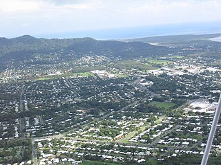
Cairns is a city in Queensland, Australia, on the tropical north east coast of Far North Queensland. In the 2021 census, Cairns had a population of 153,181 people.

<span class="mw-page-title-main">Gordonvale, Queensland</span> Suburb of Cairns, Queensland, Australia

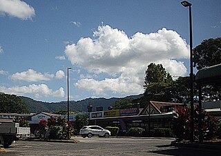
Gordonvale is a rural sugar-growing town and locality situated on the southern side of Cairns in the Cairns Region, Queensland, Australia. In the 2021 census, the locality of Gordonvale had a population of 6,944 people.

<span class="mw-page-title-main">Woree, Queensland</span> Suburb of Cairns, Queensland, Australia

Woree is a suburb of Cairns in the Cairns Region, Queensland, Australia. In the 2016 census, Woree had a population of 4,821 people.

<span class="mw-page-title-main">Edmonton, Queensland</span> Suburb of Cairns, Queensland, Australia

Edmonton is a town and suburb in the Cairns Region, Queensland, Australia. In the 2016 census, Edmonton had a population of 10,753 people.

<span class="mw-page-title-main">Cazalys Stadium</span> Stadium in Cairns, Queensland, Australia

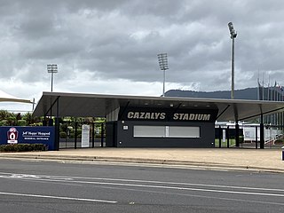
Cazalys Stadium is a sports stadium in Cairns, Queensland, Australia. It is situated in the suburb of Westcourt. The stadium is named after the social club which abuts the oval, Cazalys, which itself was named after Australian rules footballer Roy Cazaly.

<span class="mw-page-title-main">AFL Cairns</span>

AFL Cairns is a semi-professional Australian rules football league that includes clubs from the Cairns region in Queensland, Australia. It is widely regarded as the strongest regional Australian rules football league in Queensland and has a large base at Cazalys Stadium which has staged Australian Football League matches.

<span class="mw-page-title-main">Freshwater, Queensland</span> Suburb of Cairns, Queensland, Australia

Freshwater is a suburb of Cairns, Queensland, Australia. In the 2016 census, Freshwater had a population of 2,023 people.

<span class="mw-page-title-main">Trinity Beach, Queensland</span> Suburb of Cairns, Queensland, Australia

Trinity Beach is a coastal suburb of Cairns in the Cairns Region, Queensland, Australia. In the 2021 census, Trinity Beach had a population of 6,594 people.

<span class="mw-page-title-main">Mooroobool, Queensland</span> Suburb of Cairns, Queensland, Australia

Mooroobool is a suburb of Cairns in the Cairns Region, Queensland, Australia. In the 2016 census, Mooroobool had a population of 7,222 people.

<span class="mw-page-title-main">Bungalow, Queensland</span> Suburb of Cairns, Queensland, Australia

Bungalow is an inner suburb of Cairns in the Cairns Region, Queensland, Australia. In the 2016 census Bungalow had a population of 2,159 people.

<span class="mw-page-title-main">Cairns City, Queensland</span> Suburb of Cairns, Queensland, Australia

Cairns City is a coastal suburb at the centre of Cairns in the Cairns Region, Queensland, Australia. It is also known as the Cairns Central Business District (CBD). In the 2016 census, Cairns City had a population of 2,737 people.

<span class="mw-page-title-main">Manoora, Queensland</span> Suburb of Cairns, Queensland, Australia

Manoora is a suburb of Cairns in the Cairns Region, Queensland, Australia. In the 2016 census, Manoora had a population of 6,027 people.

<span class="mw-page-title-main">Kamerunga, Queensland</span> Suburb of Cairns, Queensland, Australia

Kamerunga is a suburb of Cairns in the Cairns Region, Queensland, Australia. In the 2016 census, Kamerunga had a population of 1,049 people.

<span class="mw-page-title-main">Whitfield, Queensland</span> Suburb of Cairns, Queensland, Australia

Whitfield is a suburb of Cairns in the Cairns Region, Queensland, Australia. In the 2016 census, Whitfield had a population of 4,275 people.

<span class="mw-page-title-main">Redlynch, Queensland</span> Suburb of Cairns, Queensland, Australia

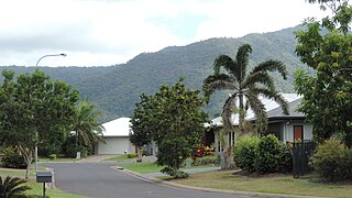
Redlynch is a semi-rural town and suburb of Cairns in the Cairns Region, Queensland, Australia. In the 2016 census, the suburb of Redlynch had a population of 9,728 people.

<span class="mw-page-title-main">Earlville, Queensland</span> Suburb of Cairns, Queensland, Australia

Earlville is a suburb of Cairns in the Cairns Region, Queensland, Australia. In the 2016 census, Earlville had a population of 4,030 people.

<span class="mw-page-title-main">Parramatta Park, Queensland</span> Suburb of Cairns, Queensland, Australia

Parramatta Park is a suburb of Cairns in the Cairns Region, Queensland, Australia. In the 2016 census, Parramatta Park had a population of 3,508 people.

<span class="mw-page-title-main">Manunda, Queensland</span> Suburb of Cairns, Queensland, Australia

Manunda is a suburb of Cairns in the Cairns Region, Queensland, Australia. In the 2016 census, Manunda had a population of 5,390 people.

<span class="mw-page-title-main">Portsmith</span> Suburb of Cairns, Queensland, Australia

Portsmith is a suburb of Cairns in the Cairns Region, Queensland, Australia. In the 2021 census, Portsmith had a population of 314 people.

<span class="mw-page-title-main">Trinity Park, Queensland</span> Suburb of Cairns, Queensland, Australia

Trinity Park is a coastal suburb of Cairns in the Cairns Region, Queensland, Australia. In the 2021 census, Trinity Park had a population of 3,536 people.

References

  1. 1 2 3 Australian Bureau of Statistics (27 June 2017). "Westcourt (SSC)". 2016 Census QuickStats. Retrieved 20 October 2018. OOjs UI icon edit-ltr-progressive.svg
  2. 1 2 "Westcourt – suburb in Cairns Region (entry 48929)". Queensland Place Names. Queensland Government . Retrieved 23 June 2020.
  3. 1 2 3 "Queensland Globe". State of Queensland . Retrieved 23 June 2020.
  4. "Indigenous culture and history". Cairns Regional Council. Archived from the original on 9 April 2020. Retrieved 23 June 2020.
  5. "Cairns Heritage: W Suburbs" (PDF). Cairns Regional Council. Archived (PDF) from the original on 13 April 2020. Retrieved 23 June 2020.
  6. heritage Alliance (2011). "A Thematic History of the City of Cairns and its Regional Towns" (PDF). Cairns Regional Council. p. 66. Archived (PDF) from the original on 23 June 2020. Retrieved 23 June 2020.
  7. "History". Jones Park. Archived from the original on 23 June 2020. Retrieved 23 June 2020.
  8. "DFO Cairns". Direct Factory Outlets. Archived from the original on 23 June 2020. Retrieved 23 June 2020.
  9. "Elite sports facilities - Cazalys Stadium". Recreation, sport and arts. Queensland Government. 30 September 2014. Archived from the original on 23 June 2020. Retrieved 23 June 2020.
  10. "Cazaly's Stadium". Cricinfo. Archived from the original on 23 June 2020. Retrieved 23 June 2020.
  11. "Cazalys Stadium". AFL Cairns. Archived from the original on 23 June 2020. Retrieved 23 June 2020.
  12. "Jones Park". Jones Park. Archived from the original on 23 June 2020. Retrieved 23 June 2020.
  13. "Google Maps: Westcourt" . Retrieved 5 March 2018.
  14. O’Neill, Rhys (7 April 2015). "Creating a park for the people". Cairns Post . Retrieved 5 March 2018.
  15. "About us". Cairns and District Family History Society Inc. Archived from the original on 12 June 2017. Retrieved 12 April 2018.

Commons-logo.svg Media related to Westcourt, Queensland at Wikimedia Commons