Kewarra Beach

Last updated

Kewarra Beach
Cairns,  Queensland
Beach looking south towards Taylor Point, Kewarra Beach, 2018 03.jpg
Beach looking south towards Taylor Point, 2018
Australia Queensland location map.svg
Red pog.svg
Kewarra Beach
Kewarra Beach
Coordinates 16°47′15″S145°40′35″E / 16.7875°S 145.6763°E / -16.7875; 145.6763 (Kewarra Beach (centre of suburb))
Population5,652 (2016 census) [1]
 • Density883/km2 (2,287/sq mi)
Postcode(s) 4879
Area6.4 km2 (2.5 sq mi)
Time zone AEST (UTC+10:00)
Location
LGA(s) Cairns Region
State electorate(s) Barron River
Federal division(s) Leichhardt
Suburbs around Kewarra Beach:
Clifton Beach Clifton Beach Coral Sea
Macalister Range Kewarra Beach Trinity Beach
Macalister Range Smithfield Trinity Beach

Kewarra Beach is a coastal suburb of Cairns in the Cairns Region, Queensland, Australia. [2] In the 2016 census, Kewarra Beach had a population of 5,652 people. [1]

Contents

Geography

Foreshore parkland, 2018 Foreshore parkland, Kewarra Beach, 2018.jpg
Foreshore parkland, 2018

Kewarra Beach is bordered by the Coral Sea to the east and Kuranda National Park to the west. The Captain Cook Highway passes through the suburb from the south-west to the north. [3]

History

Kewarra Beach is situated in the Djabugay (Tjapukai) traditional Aboriginal country. [4] The origin of the suburb name is said to be from an Aboriginal word 'kewarra', meaning 'at the footof the rainbow', though this has not been confirmed by linguists. [5]

The area was primarily utilised for growing sugar cane until the suburb was developed in the 1970s and 90s. The western side of the highway was developed with a golf course (Paradise Palms) with housing to the north and south. [6]

Trinity Anglican School opened its Kewarra Beach campus in 2002. [7]

In the 2016 census, Kewarra Beach had a population of 5,652 people. [1]

Education

Trinity Anglican School is a private primary (Prep-6) campus at Poolwood Road ( 16°47′20″S145°40′58″E / 16.7888°S 145.6829°E / -16.7888; 145.6829 (Trinity Anglican School) ) of the Trinity Anglican School at White Rock (which opened in 1983). [8] [9] [10]

There are no government schools in Kewarra Beach. The nearest government primary school is Trinity Beach State School in neighbouring Trinity Beach to the east. The nearest government secondary school is Smithfield State High School in neighbouring Smithfield to the south. [3]

Facilities

Shopping centre, 2018 Shopping centre, Kewarra Beach, 2018.jpg
Shopping centre, 2018

A small shopping centre is located on Poolwood Road.

The foreshore reserve, Pelican Park, adjoins the beach. It has a swimming enclosure that excludes marine stingers at the north end. [6] Other reserves include Brolga Park and Crocodile Park. [11]

Attractions

Tourist-oriented developments include Kewarra Beach Resort. [6] [11]

Transport

Kewarra Beach is 20 kilometres (12 mi) north of Cairns via the Captain Cook Highway. [6] Sunbus bus route 111 originates on Cottlesloe Drive and terminates at Cairns Central Shopping Centre via Trinity Beach and Trinity Park. [12]

Related Research Articles

<span class="mw-page-title-main">Cairns</span> City in Queensland, Australia

Cairns is a city in Queensland, Australia, on the tropical north east coast of Far North Queensland. The population as of the 2021 census was 169,312, having grown on average 1.02% annually over the preceding five years. The city is the 5th-most-populous in Queensland, and 15th in Australia.

<span class="mw-page-title-main">Gordonvale, Queensland</span> Suburb of Cairns, Queensland, Australia

Gordonvale is a rural sugar-growing town and locality situated on the southern side of Cairns in the Cairns Region, Queensland, Australia. In the 2021 census, the locality of Gordonvale had a population of 6,944 people.

<span class="mw-page-title-main">Captain Cook Highway</span>

The Captain Cook Highway is a short, regional highway in Queensland which originates in Cairns and terminates in Mossman, where it joins Mossman-Daintree Road, continuing to Daintree. It is a state-controlled regional road.

<span class="mw-page-title-main">Ellis Beach, Queensland</span> Suburb of Cairns Region, Queensland, Australia

Ellis Beach is a coastal locality in the Cairns Region, Queensland, Australia. In the 2021 census, Ellis Beach had a population of 5 people.

<span class="mw-page-title-main">Clifton Beach, Queensland</span> Suburb of Cairns, Queensland, Australia

Clifton Beach is a coastal suburb in the Cairns Region, Queensland, Australia. In the 2021 census, Clifton Beach had a population of 3,192 people.

<span class="mw-page-title-main">Smithfield, Queensland</span> Suburb of Cairns, Queensland, Australia

Smithfield is a suburb of Cairns in the Cairns Region, Queensland, Australia. In the 2021 census Smithfield had a population of 6,664 people.

<span class="mw-page-title-main">Yorkeys Knob, Queensland</span> Suburb of Cairns, Queensland, Australia

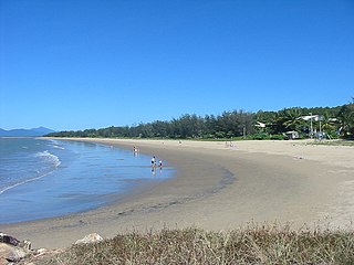
Yorkeys Knob is a coastal suburb of Cairns in the Cairns Region, Queensland, Australia. In the 2016 census, Yorkeys Knob had a population of 2,759 people.

<span class="mw-page-title-main">Palm Cove, Queensland</span> Suburb of Cairns, Queensland, Australia

Palm Cove is a suburb of Cairns in the Cairns Region, Queensland, Australia. In the 2016 census, Palm Cove had a population of 2,059 people.

<span class="mw-page-title-main">Holloways Beach, Queensland</span> Suburb of Cairns, Queensland, Australia

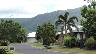
Holloways Beach is a residential coastal suburb of Cairns, Queensland, Australia. In the 2021 census, Holloways Beach had a population of 2,398 people. II is located about 10 kilometres north of the city of Cairns between the suburbs of Machans Beach and Yorkeys Knob.

<span class="mw-page-title-main">Sunbus Cairns</span>

Sunbus Cairns, previously Marlin Coast Sunbus, was the principal bus operator in Cairns, Queensland operating services under the TransLink (Queensland) scheme in the Cairns region. It is one of Sunbus' operations. As of late 2022, Sunbus has changed its name as part of a business re-brand by the parent company, Kinetic. Sunbus has now been dissolved into the Kinetic brand with its fleet of buses reflecting this change.

<span class="mw-page-title-main">Aeroglen</span> Suburb of Cairns, Queensland, Australia

Aeroglen is a coastal suburb of Cairns in the Cairns Region, Queensland, Australia. In the 2016 census, Aeroglen had a population of 403 people.

<span class="mw-page-title-main">Trinity Beach, Queensland</span> Suburb of Cairns, Queensland, Australia

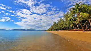
Trinity Beach is a coastal suburb of Cairns in the Cairns Region, Queensland, Australia. In the 2021 census, Trinity Beach had a population of 6,594 people.

<span class="mw-page-title-main">Bungalow, Queensland</span> Suburb of Cairns, Queensland, Australia

Bungalow is an inner suburb of Cairns in the Cairns Region, Queensland, Australia. In the 2016 census Bungalow had a population of 2,159 people.

<span class="mw-page-title-main">Cairns City, Queensland</span> Suburb of Cairns, Queensland, Australia

Cairns City is a coastal suburb at the centre of Cairns in the Cairns Region, Queensland, Australia. It is also known as the Cairns Central Business District (CBD). In the 2016 census, Cairns City had a population of 2,737 people.

<span class="mw-page-title-main">Cairns North, Queensland</span> Suburb of Cairns, Queensland, Australia

Cairns North is a coastal suburb of Cairns in the Cairns Region, Queensland, Australia. In the 2021 census, Cairns North had a population of 5,334 people.

<span class="mw-page-title-main">White Rock, Queensland (Cairns Region)</span> Suburb of Cairns, Queensland, Australia

White Rock is a suburb of Cairns in the Cairns Region, Queensland, Australia. In the 2016 census, White Rock had a population of 4,730 people.

<span class="mw-page-title-main">Barron, Queensland</span> Suburb of Cairns, Queensland, Australia

Barron is a suburb of Cairns in the Cairns Region, Queensland, Australia. In the 2016 census Barron had a population of 42 people.

<span class="mw-page-title-main">Portsmith</span> Suburb of Cairns, Queensland, Australia

Portsmith is a suburb of Cairns in the Cairns Region, Queensland, Australia. In the 2021 census, Portsmith had a population of 314 people.

<span class="mw-page-title-main">Trinity Park, Queensland</span> Suburb of Cairns, Queensland, Australia

Trinity Park is a coastal suburb of Cairns in the Cairns Region, Queensland, Australia. In the 2021 census, Trinity Park had a population of 3,536 people.

<span class="mw-page-title-main">Westcourt, Queensland</span> Suburb of Cairns, Queensland, Australia

Westcourt is a suburb of Cairns in the Cairns Region, Queensland, Australia. In the 2016 census, Westcourt had a population of 3,918 people.

References

  1. 1 2 3 Australian Bureau of Statistics (27 June 2017). "Kewarra Beach (SSC)". 2016 Census QuickStats. Retrieved 20 October 2018. OOjs UI icon edit-ltr-progressive.svg
  2. "Kewarra Beach – suburb in Cairns Region (entry 48697)". Queensland Place Names. Queensland Government . Retrieved 19 July 2021.
  3. 1 2 "Queensland Globe". State of Queensland . Retrieved 21 December 2021.
  4. "First people cultural history". Cairns Regional Council. Archived from the original on 9 April 2020. Retrieved 23 June 2020.
  5. "Cairns Heritage: K Suburbs" (PDF). Cairns Regional Council. Archived (PDF) from the original on 22 April 2018. Retrieved 23 June 2020.
  6. 1 2 3 4 "Kewarra Beach". Centre for the Government of Queensland. Archived from the original on 5 September 2013. Retrieved 14 July 2013.
  7. Queensland Family History Society (2010), Queensland schools past and present (Version 1.01 ed.), Queensland Family History Society, ISBN   978-1-921171-26-0
  8. "State and non-state school details". Queensland Government. 9 July 2018. Archived from the original on 21 November 2018. Retrieved 21 November 2018.
  9. "Trinity Anglican School". Archived from the original on 19 November 2018. Retrieved 21 November 2018.
  10. "About TAS". Trinity Grammar School. Archived from the original on 27 July 2013. Retrieved 14 July 2013.
  11. 1 2 "Kewarra Beach community profile". profile.id. Archived from the original on 29 September 2013. Retrieved 14 July 2013.
  12. "Information about zones, fares, tickets, ticket types, ticket prices, concessions etc". Sunbus. Archived from the original on 30 June 2013. Retrieved 14 July 2013.