Prospect Creek (New South Wales)

Last updated

Prospect Creek
Prospectcreek.png
Prospect Creek, as it flows in Fairfield.
Sydney AST2001oct12 lrg.jpg
Red pog.svg
NASA satellite view of Greater Metropolitan Sydney, with the Prospect Creek mouth location, as marked
Location
Country Australia
State New South Wales
Region Sydney Basin (IBRA), Greater Western Sydney, Canterbury-Bankstown, Southern Sydney
LGAs Blacktown, Cumberland, Fairfield, Liverpool, Canterbury-Bankstown
Physical characteristics
Source Prospect Reservoir
  locationnorth of Bulls Hill, Prospect
  coordinates 33°50′2″S150°53′20″E / 33.83389°S 150.88889°E / -33.83389; 150.88889
Mouth confluence with the Georges River
  location
Dhurawal Bay, Georges Hall
  coordinates
33°54′35″S150°58′25″E / 33.90972°S 150.97361°E / -33.90972; 150.97361
Length26 km (16 mi)
Basin size98 km2 (38 sq mi)
Basin features
River system Sydney Basin catchment
Dam / Reservoir Prospect Reservoir
[1] [2]

Prospect Creek is an urban watercourse of the Georges River catchment that is located in the western region of Sydney, in New South Wales, Australia. As Prospect Reservoir forms a part of the Sydney metropolitan water supply, the flow of the creek is regulated in accordance with the operational requirements of Sydney Water.

Contents

Situated within the local government areas of Fairfield City and Canterbury-Bankstown Councils, the creek is 26 kilometres (16 mi) long, starting at the Prospect Reservoir at the top of the catchment and flows to the Georges River at Georges Hall, as its tributary.

Course and features

Prospect Creek rises below Prospect Reservoir, north of Bulls Hill in Prospect, within the Blacktown local government area, and flows generally southeast by east, through the Holroyd, Fairfield, Liverpool and Bankstown local government areas, before reaching its confluence with the Georges River, at Georges Hall, spilling into Dhurawal Bay in the Chipping Norton Lakes. [1]

The catchment area of the creek is approximately 98 square kilometres (38 sq mi), and is largely urbanised with industrial land uses, residential and open space for recreation. [2]

Regulations

Most forms of fishing are permitted in Prospect Creek, in both the tidal (lower) and freshwater (upper) catchments with fishing subject to bag and size limit regulations. [3] In 2023, Sydney Water Corporation was convicted and fined $200,000 in the Land and Environment Court of NSW after 282,000 litres of sewage was spilled into the creek. [4]

Catchment

The creek's catchment area itself is a sub-catchment of the Georges River catchment, where it covers an area of 98 square kilometres. Areas within the Prospect Creek Catchment include, Fairfield City (65.6%), Cumberland Council (13.7%), Bankstown (10.5%), Blacktown (7.8%) and Liverpool (2.4%). Some of the streams and drainage lines in the catchment do not permanently transport water, and rather would only do so after rain events. [5]

Wetlands in the and ponds within the Prospect Creek catchment include, Warren Road, Woodpark (an artificial wetland); Gipps Road Park, De Freitas Wetland at Vine Street, Clarevale Wetland, Lake Mirambeena (Lansdowne) and Lake Gillawarna (Georges Hall). Clear Paddock Creek, Green Valley Creek and Orphan School Creek are all part of the Prospect Creek catchment, in addition to being Prospect Creek's tributaries (branches). [5]

Drainage systems

Other systems that supply to the Prospect Creek include: [5]

The creek flowing in Smithfield Swamp Oak Forest.jpg
The creek flowing in Smithfield

There are catchment drains that lead to Prospect Creek in a northeasterly direction; They consist of three concrete-lined, trapezoidal-shaped channels that are 3.8km in length, 1.5 metres to 1.75 metres in width and a height that ranges from approximately 2.0 metres to 3.0 metres: [6]

Recreation

The creek flowing under the Lansdowne Bridge, Lansdowne. Lansdownebridge1.jpg
The creek flowing under the Lansdowne Bridge, Lansdowne.

The creek winds through a number of parks and reserves, with the most prominent ones being, Gipps Road Sporting Complex, Rosford Street Reserve and the contiguous Long Street Park in Smithfield, Fairfield Park Precinct and Cawarra Park in Fairfield, Fairfield Road Park in Yennora, Makepeace Oval in Fairfield, Carrawood Park in Carramar, Mirambeena Regional Park in Lansdowne, and Henry Lawson Reserve in Georges Hall, going from northwest to southeast. It also flows on the western fringes of Fairfield High School and just north of Bland Oak, a historical tree.

There are walkways or cycling paths that parallel the creek. The longest, continuous walking path that runs alongside creek starts from Widmere Road, adjacent to the Liverpool–Parramatta T-way, in the northern periphery of Wetherill Park, and ends at Fairfield Road Park in Yennora, opposite of Yennora Fire Station. The walkabouts are within the surroundings of the Australian bushland, which include native trees such as eucalyptus. [7]

River status

In 2020 a proposal was submitted to upgrade a 6 kilometre (4 mi) stretch of Prospect Creek river status. [8] In September 2020, this proposal went before the Geographical Names Board of NSW (GNB) after Community Advocate Lachlan Hyde with the support of local state MPs [9] pushed the New South Wales Government on the matter. [8] This section would then be named Lennox River to honour Scottish-Australian stonemason David Lennox who designed and oversaw the construction of the Lansdowne Bridge which crosses this waterway. [8]

Related Research Articles

<span class="mw-page-title-main">Greater Western Sydney</span> Region of the metropolitan area of Sydney, Australia

Greater Western Sydney (GWS) is a large region of the metropolitan area of Greater Sydney, New South Wales (NSW), Australia that generally embraces the north-west, south-west, central-west, far western and the Blue Mountains sub-regions within Sydney's metropolitan area and encompasses 11 local government areas: Blacktown, Blue Mountains, Camden, Campbelltown, Cumberland, Fairfield, Hawkesbury, Liverpool, Parramatta, Penrith and Wollondilly. It includes Western Sydney, which has a number of different definitions, although the one consistently used is the region composed of ten local government authorities, most of which are members of the Western Sydney Regional Organisation of Councils (WSROC). The NSW Government's Office of Western Sydney calls the region "Greater Western Sydney".

Wetherill Park is a suburb in Greater Western Sydney, in the state of New South Wales, Australia. Wetherill Park is located 34 kilometres west of the Sydney central business district, in the local government area of the City of Fairfield.

<span class="mw-page-title-main">Smithfield, New South Wales</span> Suburb of Sydney, New South Wales, Australia

Smithfield is a suburb of Sydney, in the state of New South Wales, Australia. Smithfield is located 31 kilometres (19 mi) west of the Sydney central business district, in the local government areas of the City of Fairfield and Cumberland Council. Located in the Greater Western Sydney region, the suburb is one of the largest in Fairfield City by area.

The Liverpool–Parramatta T-way is a continuous series of bus-only lanes and bus roadways between Parramatta and Liverpool in Western Sydney. Completed in February 2003, the 31 km (19.3 mi) T-way was the first bus rapid transit infrastructure to be built in Sydney.

<span class="mw-page-title-main">Lower Prospect Canal Reserve</span> Australian nature reserve

The Lower Prospect Canal Reserve is a heritage-listed former farm and public water supply canal and now bushy corridor and nature reserve stretching 7.7 kilometres (4.8 mi) through the heart of suburban Sydney, New South Wales, Australia. The lineal corridor stretches from Prospect Reservoir to Sydney Water Pipehead at Albert Street, Guildford with the majority of the reserve located in Greystanes, which is a suburb within the Cumberland Council area.

<span class="mw-page-title-main">Lansdowne, New South Wales</span> Suburb of Sydney, New South Wales, Australia

Lansdowne is a suburb in south-western Sydney, in the state of New South Wales, Australia. Lansdowne is located 27 kilometres west of the Sydney central business district, in the local government area of the City of Canterbury-Bankstown and is part of the South-western Sydney region. Its western boundary is Prospect Creek, the north the Hume Highway and the east and south Georges Hall.

<span class="mw-page-title-main">Whites Creek (Annandale)</span> River in New South Wales, Australia

Whites Creek, formerly known as White's Creek, was once a natural waterway that was concreted to improve sanitation. The creek is now a heritage–listed artificial waterway located in the inner–west region of Sydney, New South Wales, Australia.

<span class="mw-page-title-main">Duck River (New South Wales)</span> River in New South Wales, Australia

The Duck River is a perennial stream and southern tributary of the Parramatta River, in Sydney, New South Wales, Australia.

<span class="mw-page-title-main">Division of McMahon</span> Australian federal electoral division

The Division of McMahon is an Australian electoral division in the state of New South Wales.

<span class="mw-page-title-main">Bike paths in Sydney</span> Bike paths

Bike paths in Sydney, New South Wales, Australia, vary widely, with the majority either shared cycle and pedestrian paths or on road paths, and a small number of separated cycleways. In 2009 the Sydney Morning Herald reported that "Sydney's cycleways are not so much an organised network as a fragmented collection of winding paths and half-finished ideas. Most were built or designed when cycling was viewed as a pleasant pastime rather than a practical form of travel and are now poorly suited to commuting."

<span class="mw-page-title-main">Clear Paddock Creek</span>

Clear Paddock Creek is a tributary of Orphan School Creek, which in turn, is a tributary of Prospect Creek, located in the City of Fairfield, NSW. The creek, being mostly concrete-lined, starts from Brisbane Road in St Johns Park and ends at Orphan School Creek to the east near King Road in Fairfield West.

<span class="mw-page-title-main">Lansdowne Bridge</span> Bridge

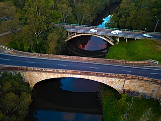
The Lansdowne Bridge is a heritage-listed road bridge that carries the northbound carriageway of the Hume Highway across Prospect Creek between Lansvale and Lansdowne. Situated in southwestern Sydney it is located on the boundary of the Fairfield and Canterbury-Bankstown local government areas. The bridge was named in honour of Henry Petty-Fitzmaurice, 3rd Marquess of Lansdowne (1780–1863), an Irish Whig politician of the British Parliament and associate of the NSW Governor of the day, Sir Richard Bourke.

<span class="mw-page-title-main">Brenan Park</span> Urban park in Sydney, Australia

Brenan Park is a 20-hectare (49-acre) urban park situated in the western suburbs of Sydney, New South Wales, Australia. Primarily categorised as a sports field, the reserve contains an open grassland, bushland and recreational areas within the vicinity of native plants, such as eucalyptus trees. It is named after John Ryan Brenan, who founded the suburb of Smithfield in 1836.

<span class="mw-page-title-main">Rosford Street Reserve</span>

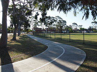
Rosford Street Reserve, or Rosford Reserve, is an urban park and nature reserve situated in the western suburbs of Sydney, New South Wales, Australia. The reserve contains an open grassland, woodlands and recreational areas surrounded by native plants, such as eucalyptus trees. Janice Crosio Oval is a fenced sports ground incorporated within the reserve. The park is one of the largest in the Fairfield LGA area.

<span class="mw-page-title-main">Cumberland Plain Woodland</span> Indigenous woodland community in Sydney, Australia

The Cumberland Plain Woodland, also known as Cumberland Plain Bushland and Western Sydney woodland, is a grassy woodland community found predominantly in Western Sydney, New South Wales, Australia, that comprises an open tree canopy, a groundcover with grasses and herbs, usually with layers of shrubs and/or small trees.

<span class="mw-page-title-main">Bland Oak</span>

The Bland Oak, or Bland's Oak Tree, is a historic Southern live oak situated in Greater Western Sydney, New South Wales, Australia, that is approximately over 170 years old, making it one of Sydney's oldest living introduced trees and also one of the largest in the region. A local significance and a historic symbol of Fairfield City Council, the oak tree is included on Fairfield City's coat of arms.

<span class="mw-page-title-main">The Horsley Drive</span> Road in Sydney, Australia

The Horsley Drive is a 13-kilometre (8.1 mi) urban sealed road located in the City of Fairfield in Greater Western Sydney, New South Wales, Australia. The road's northwestern terminus is located at the entrance of Western Sydney Parklands in Horsley Park and its southeastern terminus at its intersection with Hume Highway in Carramar.

<span class="mw-page-title-main">Prospect Nature Reserve</span>

Prospect Nature Reserve is a nature reserve and recreational area that is situated in the western suburbs of Sydney, New South Wales, Australia, which incorporates the Prospect Reservoir, and also features picnic spots, lookouts, walking tracks and BBQ areas within the Australian bush. It is located within the Blacktown City local government area, but is also close to the boundaries of Cumberland Council and the City of Fairfield.

<span class="mw-page-title-main">Smithfield West</span> Place in New South Wales, Australia

Smithfield West is a locality situated in western Sydney, New South Wales, Australia. Part of Smithfield, it is an unofficial designation for the region, or neighbourhood area, westwards from Dublin Street to Wetherill Street on the boundary of Wetherill Park.

<span class="mw-page-title-main">Lennox River</span> River in New South Wales, Australia

The Lennox River is the proposed name for a waterway located in Sydney's South-Western Suburbs. The existing waterway is the tidal reach of Prospect Creek, a tributary of the Georges River. A proposal has been made to upgrade and reclassify the waterway as a 'river'. The proposed river would be 6.5 kilometres (4 mi) long, starting at the confluence of Orphan School Creek and Prospect Creek at Fairfield and flowing to the Georges River emptying into Dhurawal Bay at Garrison Point.

References

  1. 1 2 "Prospect Creek". Geographical Names Register (GNR) of NSW. Geographical Names Board of New South Wales . Retrieved 10 April 2013. OOjs UI icon edit-ltr-progressive.svg
  2. 1 2 "Prospect Creek". Rivers and Creeks. Bankstown City Council . Retrieved 10 April 2013.
  3. "PROSPECT CREEK FISHING". Parliament of NSW. 24 November 2020.
  4. Sydney Water fined for polluting Prospect Creek Prime Creative Media. Retrieved 7 December 2023.
  5. 1 2 3 5 Creeks: Facts & Figures Fairfield City Council. Retrieved 6 December 2023.
  6. Wetherill Park Overland Flood Study Fairfield City Council. February 2015. Retrieved 7 December 2023.
  7. King M & Associates (1997) Recreation Needs Assessment Study prepared for Fairfield City Council
  8. 1 2 3 Boulous, Chris (17 September 2020). "River me this: Push to upgrade part of Prospect Creek". Fairfield City Champion. Retrieved 18 September 2020.
  9. Boulous, Chris (12 November 2020). "'Fitting tribute': MPs support plan to upgrade Prospect Creek". Fairfield City Champion. Retrieved 12 November 2020.