| Mowamba River Moonbah River [1] | |
|---|---|
| Location | |
| Country | Australia |
| State | New South Wales |
| Region | Australian Alps (IBRA), Snowy Mountains |
| Local government area | Snowy Monaro Regional Council |
| Physical characteristics | |
| Source | Snowy Mountains, Great Dividing Range |
| • location | near Mount Terrible |
| • elevation | 1,360 m (4,460 ft) |
| Mouth | confluence with the Snowy River |
• location | near Jindabyne |
• elevation | 853 m (2,799 ft) |
| Length | 32 km (20 mi) |
| Basin features | |
| River system | Snowy River catchment |
| Tributaries | |
| • left | Tulon Creek |
| • right | Grosses Plain Creek |
| National park | Kosciuszko NP |
| [1] [2] | |
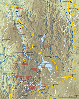
The Mowamba River, a perennial river of the Snowy River catchment, is located in the Snowy Mountains region of New South Wales, Australia.
The Mowamba River rises within The Snowy Mountains Range, part of the Great Dividing Range, contained within the Kosciuszko National Park, on the northeastern slopes of Mount Terrible. The river flows generally south then northeast by east, joined by two minor tributaries, before reaching its confluence with the Snowy River approximately 2 kilometres (1.2 mi) south of Jindabyne, in the Jindabyne Gorge. [1] The river descends 507 metres (1,663 ft) over its 32 kilometres (20 mi) course. [2]
Water from the Mowamba River is diverted to Jindabyne Dam via the Mowamba weir and aqueduct; that is part of the Snowy Mountains Scheme.[ citation needed ]
On 28 August 2002, the Mowamba Weir was "turned out" allowing environmental water to over top the weir. Environmental water releases occurred until January 2006. Since January 2006, environmental water releases to the Snowy River have occurred from Jindabyne Dam as the infrastructure upgrades to the dam wall had been completed.[ citation needed ]
The Snowy Mountains Scheme, also known as the Snowy Hydro or the Snowy scheme, is a hydroelectricity and irrigation complex in south-east Australia, Near the border of NSW and Victoria (Australia). The Scheme consists of sixteen major dams; nine power stations; two pumping stations; and 225 kilometres (140 mi) of tunnels, pipelines and aqueducts that were constructed between 1949 and 1974. The Scheme was completed under the supervision of Chief Engineer, Sir William Hudson. It is the largest engineering project undertaken in Australia.

The Snowy River is a major river in south-eastern Australia. It originates on the slopes of Mount Kosciuszko, Australia's highest mainland peak, draining the eastern slopes of the Snowy Mountains in New South Wales, before flowing through the Alpine National Park and the Snowy River National Park in Victoria and emptying into Bass Strait.

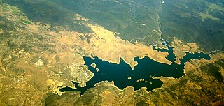
The Eucumbene River, a perennial river of the Snowy River catchment, is located in the Snowy Mountains region of New South Wales, Australia.

Jindabyne is a town in south-east New South Wales, Australia that overlooks Lake Jindabyne near the Snowy Mountains, in Snowy Monaro Regional Council. It is a popular holiday destination year round, especially in winter. This is due to its proximity to major ski resort developments within the Kosciuszko National Park, including Thredbo, Perisher and Charlotte Pass.
Jindabyne Dam is a major ungated rockfill embankment dam across the Snowy River in the Snowy Mountains of New South Wales, Australia. The dam's main purpose is for the generation of hydro-power and is one of the sixteen major dams that comprise the Snowy Mountains Scheme, a vast hydroelectricity and irrigation complex constructed in south-east Australia between 1949 and 1974 and now run by Snowy Hydro.

The Thredbo River, a perennial river of the Snowy River catchment, is located in the Snowy Mountains region of New South Wales, Australia.
The Gungarlin River, a perennial river of the Snowy River catchment, is located in the Snowy Mountains region of New South Wales, Australia.

Tantangara Dam is a major ungated concrete gravity dam with concrete chute spillway across the Murrumbidgee River in Tantangara, upstream of Adaminaby in the Snowy Mountains region of New South Wales, Australia. The dam is part of the Snowy Mountains Scheme, a vast hydroelectricity and irrigation complex constructed in south-east Australia between 1949 and 1974 and now run by Snowy Hydro. The purpose of the dam includes water management and conservation, with much of the impounded headwaters diverted to Lake Eucumbene. The impounded reservoir is called Tantangara Reservoir.
The Bombala River, a perennial river of the Snowy River catchment, is located in the Monaro region of New South Wales, Australia.

The Tumut River, a perennial stream that is part of the Murrumbidgee catchment within the Murray–Darling basin, is located in the Snowy Mountains and South West Slopes districts of New South Wales, Australia.
Tooma River, a perennial stream that has had some of its flow diverted as a result of the Snowy Mountains Scheme, is part of the Murray catchment within the Murray–Darling basin and is located in the Australian Alpine region of New South Wales, Australia.

Barnard River, a perennial river of the Manning River catchment, is located in the Northern Tablelands and Mid North Coast districts of New South Wales, Australia.
The Geehi River, a perennial river of the Murray catchment of the Murray–Darling basin, is located in the Snowy Mountains region of New South Wales, Australia.
The Jacobs River, a perennial river of the Snowy River catchment, is located in the Snowy Mountains region of New South Wales, Australia.
The Nunnock River, a perennial stream of the Bega River catchment, is located in the Monaro region of New South Wales, Australia.
The Pinch River, a perennial river of the Snowy River catchment, is located in the Snowy Mountains region of New South Wales, Australia.
The Yarrangobilly River is a perennial river of the Murrumbidgee River catchment within the Murray–Darling basin, located in the Snowy Mountains region of New South Wales, Australia.
Doubtful Creek, formerly known as Doubtful River, a watercourse that is part of the Murrumbidgee catchment within the Murray–Darling basin, is located in the Snowy Mountains district of New South Wales, Australia.
Island Bend Dam is a major ungated concrete gravity dam with a controlled spillway across the Snowy River in the Snowy Mountains region of New South Wales, Australia. The dam's main purpose is for the diversion of water for generation of hydro-power and is one of the sixteen major dams that comprise the Snowy Mountains Scheme, a vast hydroelectricity and irrigation complex constructed in south-east Australia between 1949 and 1974 and now run by Snowy Hydro.
The Burrungubugge River, a perennial river of the Snowy River catchment, is located in the Snowy Mountains region of New South Wales, Australia.
Rivers of the Southern Rivers catchment, New South Wales, Australia | |
|---|---|
| Illawarra | |
| Shoalhaven | |
| Eurobodalla | |
| Far South Coast | |
| Snowy River | |
| Townships and Villages | |
|---|---|
| Localities and rural places | |
| National parks and other natural features | |
| Rivers and other watercourses | |
| Dams and/or associated reservoirs | |
| Mountain ranges | |
| Attractions | |
Main Article: Local government areas of New South Wales | |