
Myall Lakes, a series of fresh water lakes protected under the Ramsar Convention, are located within the Mid-Coast Council local government area in the Mid North Coast region of New South Wales, Australia.

Port Stephens, an open youthful tide-dominated drowned-valley estuary, is a large natural harbour of approximately 134 square kilometres (52 sq mi) located in the Hunter Region of New South Wales, Australia.
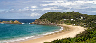
Seal Rocks is a small coastal settlement in the Mid-Coast Council local government area, in the Mid North Coast region of New South Wales, Australia, 275 kilometres (171 mi) north-north-east of Sydney. It is famous for its many premier surfing beaches, and also for being the home of Seal Rocks lighthouse, officially known as Sugarloaf Point Lighthouse. At the 2006 census, the area had a population of 131 persons.
Hawks Nest is a small town of the Mid-Coast Council local government area in the Hunter and Mid North Coast regions of New South Wales, Australia, located north of Port Stephens between the Tasman Sea and the Myall River. It was named after a large hawk's nest in a tree on the Myall River that was used as a navigational aid. The traditional custodians of this land are the Worimi people.

Great Lakes Council was a local government area in the Mid North Coast region of New South Wales, Australia. The area is situated adjacent to the shores of Port Stephens, Myall Lakes and Wallis Lake and the Pacific Highway and the Lakes Way. On 12 May 2016 the council was dissolved and the area included in the Mid-Coast Council, along with City of Greater Taree and Gloucester Shire.

Bulahdelah is a town and locality in the Hunter/Mid North Coast region of New South Wales, Australia in the Mid-Coast Council local government area. At the 2016 census, the locality had a population of 1,424. The main population centre, where 69% of the area's population lived in 2006, is the town of Bulahdelah.
Failford is a locality in the Mid-Coast Council local government area on the Mid North Coast of New South Wales, Australia. Located to the east of the Pacific Highway, Failford is about 15 km (9 mi) northwest of Forster. At the 2011 census it had a population of 495.

Myall River, an open semi-mature brackish freshwater barrier estuary of the Mid-Coast Council system, is located in the Mid North Coast region of New South Wales, Australia.
Coolongolook River, a watercourse of the Mid-Coast Council system, is located in the Mid North Coast district of New South Wales, Australia.

Gloucester River, a perennial river and major tributary of the Manning River catchment, is located in the Mid North Coast hinterland New South Wales, Australia.
Mammy Johnsons River, a mostly perennial river of the Mid-Coast Council system, is located in the Mid North Coast and Upper Hunter regions of New South Wales, Australia.

Telegherry River, a perennial river of the Mid-Coast Council system, is located in the Mid North Coast and Upper Hunter regions of New South Wales, Australia.
The Branch River, a watercourse of the Mid-Coast Council system, is located in the Mid North Coast and Upper Hunter regions of New South Wales, Australia.

Wallamba River, a watercourse of the Mid-Coast Council system, is located in the Mid North Coast district of New South Wales, Australia.
Wallingat River, a watercourse of the Mid-Coast Council system, is located in the Mid North Coast district of New South Wales, Australia.
Wang Wauk River, a perennial river of the Great Lakes system, is located in the Mid North Coast region of New South Wales, Australia.
Wards River, a mostly perennial river of the Mid-Coast Council system, is located in the Mid North Coast and Upper Hunter regions of New South Wales, Australia.

Wallis Lake, an open and trained wave dominated barrier estuary, is located within the Mid-Coast Council local government area in the Mid North Coast region of New South Wales, Australia. Wallis Lake is located adjacent to the towns of Forster and Tuncurry, and adjacent to the east coast, about 308 kilometres (191 mi) north of Sydney.
Smiths Lake, an intermittently closed youthful saline coastal lagoon, is located within the Mid-Coast Council local government area in the Mid North Coast region of New South Wales, Australia. Smiths Lake is located adjacent to the village of Smiths Lake, and adjacent to the east coast, about 274 kilometres (170 mi) north of Sydney.

MidCoast Council is a local government area (LGA) located in the Mid North Coast region of New South Wales, Australia. The council was formed on 12 May 2016 through a merger of the Gloucester Shire, Great Lakes and City of Greater Taree councils.
