
Georges Hall, a suburb of local government area City of Canterbury-Bankstown, is located 24 kilometres south-west of the Sydney central business district in the state of New South Wales, Australia, and is part of the South-western Sydney region.

Field Marshal William Riddell Birdwood, 1st Baron Birdwood, was a British Army officer. He saw active service in the Second Boer War on the staff of Lord Kitchener. He saw action again in the First World War as commander of the Australian and New Zealand Army Corps during the Gallipoli Campaign in 1915, leading the landings on the peninsula and then the evacuation later in the year, before becoming commander-in-chief of the Fifth Army on the Western Front during the closing stages of the war. He went on to be general officer commanding the Northern Army in India in 1920 and Commander-in-Chief, India, in 1925.

The Australian Corps was a World War I army corps that contained all five Australian infantry divisions serving on the Western Front. It was the largest corps fielded by the British Empire in France. At its peak the Australian Corps numbered 109,881 men. By 1918 the headquarters consisted of more than 300 personnel of all ranks, including senior staff officers, as well as supporting personnel such as clerks, drivers and batmen. Formed on 1 November 1917, the corps replaced I Anzac Corps while II Anzac Corps, which contained the New Zealand Division, became the British XXII Corps on 31 December. While its structure varied, Australian Corps usually included 4–5 infantry divisions, corps artillery and heavy artillery, a corps flying squadron and captive balloon sections, anti-aircraft batteries, corps engineers, corps mounted troops, ordnance workshops, medical and dental units, transport, salvage and an employment company.

The Mid Murray Council is a local government area in South Australia in the Murray and Mallee region of South Australia. The council spans the area from the Riverland through the Murraylands to the eastern slopes of the Mount Lofty Ranges. It includes 220 km of the Murray River. The council seat is at Mannum; it also maintains secondary offices at Cambrai and Morgan.

Adelaide Hills Council is a local government area in the Adelaide Hills of South Australia. It is in the hills east of Adelaide, the capital of South Australia. It extends from the South Para Reservoir in the north, to the Mount Bold Reservoir in the south.

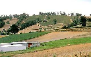
Birdwood is a town near Adelaide, South Australia. It is located in the local government areas of the Adelaide Hills Council and the Mid Murray Council.
The Adelaide Hills region is located in the southern Mount Lofty Ranges east of the city of Adelaide in the state of South Australia. The largest town in the area, Mount Barker is one of Australia's fastest-growing towns. Before British colonisation of South Australia, the area was inhabited by the Peramangk people.

Balhannah is a town in the Adelaide Hills about 30 km southeast of Adelaide, the capital of South Australia. It was established in 1839 as a farming community by James Turnbull Thomson, who built the first hotel. The town soon grew to incorporate two once adjoining towns: Gilleston and Blythetown, named for James Blythe, another Scottish settler.

Belfield is a suburb of Sydney, in the state of New South Wales, Australia. It is 13 kilometres southwest of the Sydney central business district, in the local government area of the City of Canterbury-Bankstown.

East Killara is a suburb on the Upper North Shore of Sydney in the state of New South Wales, Australia. East Killara is located 15 kilometres north of the Sydney Central Business District in the local government area of Ku-ring-gai Council. It is bordered by Garigal national park to the East and Eastern Arterial Rd/ Birdwood Ave to the west. Killara is a separate suburb to the south-west, which shares the postcode of 2071.
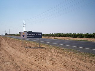
Birwoodton is a locality situated in the Sunraysia region, in north western Victoria, Australia. The place by road, is situated about 4 kilometres south of Merbein and 14 kilometres northwest of Mildura.

Gumeracha is a town in the Adelaide Hills, South Australia, located on the Adelaide-Mannum Road. It is located in the Adelaide Hills Council local government area on the south bank of the upper River Torrens. At the 2006 census, Gumeracha had a population of 731.
Forreston is a locality near Adelaide, South Australia. It is located in the Adelaide Hills Council local government area 3 km northeast of Gumeracha.

Mount Torrens is a town in the eastern Adelaide Hills region of South Australia, 46 kilometres east-north-east of the state capital, Adelaide and 8 km east of Lobethal. It is located in the Adelaide Hills Council and the Mid Murray Council local government areas. At the 2006 census, Mount Torrens had a population of 337.

Lieutenant General James Gordon Legge, was an Australian Army senior officer who served in the First World War and was the Chief of the General Staff, Australia's highest ranking army officer between 1914 and 1915 and again from 1917 to 1920. His son, Stanley Ferguson Legge, reached the rank of major general.
The Hills Football League (HFL) is an Australian rules football league, situated in the Adelaide Hills region of South Australia, to the south east of the state capital Adelaide.
Birdwood High School is a public high school in the Adelaide Hills town, Birdwood. Birdwood High School was founded in 1909 and is located beside Birdwood Primary School.

The Bay to Birdwood is a motoring event of citizen-collected vehicles that takes place annually in South Australia, formerly consisting of the Bay to Birdwood Run and the Bay to Birdwood Classic, which ran in even- and odd-numbered years alternately. Since 2020 it has been a large-scale run including vintage, veteran and classic cars and other road vehicles. It commences in the coastal Adelaide suburb of West Beach and concluding at the National Motor Museum in the Adelaide Hills town of Birdwood.
Mount Crawford is a locality in the Mount Lofty Ranges of South Australia. It is named after the mountain of the same name in its boundaries, also known as Teetaka.
Rānui is a suburb of West Auckland, New Zealand, which is under the local governance of Auckland Council. The area is densely populated but close to the western fringe of the Auckland urban area.
