
Sheringham Park is a landscape park and gardens near the town of Sheringham, Norfolk, England. The park surrounds Sheringham Hall, lying mostly to its south. The freehold of the hall is owned by the National Trust and is privately leased on a long leasehold. Visitors to this historic building must contact the leaseholder directly for an appointment. The plantations of Sheringham Park are in the care of the National Trust and open to visitors. National Trust members and guests have no rights of access across the park and farmland surrounding Sheringham Hall. Access to these areas is solely at the discretion of George Youngs (Farms) Ltd which farms the Sheringham estate, as laid out in the 1953 agreement between that farming company and the then freeholder. Access to the plantations of Sheringham Park has become an important aspect to locals of Sheringham and visitors alike and reference to this can be found in the Domesday Book, page 56.

Nambucca Heads is a town on the Mid North Coast of New South Wales, Australia in the Nambucca Valley. It is located on a ridge, north of the estuary of the Nambucca River near the Pacific Highway. Its 2021 population was 6,675, including 5,226 (78.3%) Australian-born persons and 672 indigenous persons.
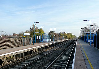
Willington railway station serves the village of Willington in Derbyshire, England. The station is 6¼ miles (10 km) south-west of Derby on the Cross Country Route. The station is operated by East Midlands Railway but none of their services calls here. Only CrossCountry services call at the station.
Colongra is a suburb of the Central Coast region of New South Wales, Australia, on the banks of Lake Munmorah. It is part of the Central Coast Council local government area.

Bellingen Shire is a local government area in the Mid North Coast region of New South Wales, Australia. The shire is located adjacent to the Pacific Highway, Waterfall Way and the North Coast railway line.
Eudlo is a rural town and locality in the Sunshine Coast Region, Queensland, Australia. In the 2021 census, the locality of Eudlo had a population of 1,192 people.
Raleigh is a small town in the Mid North Coast region of New South Wales, Australia, in Bellingen Shire. At the 2011 census, Raleigh had a population of 550. The town is south of Coffs Harbour and Sawtell and north of Nambucca Heads. It is located in Raleigh County and is perhaps named after it. It has one school, Raleigh Public School, which is located opposite a Norco dairy factory. A railway station on the North Coast line opened in 1915, but was subsequently closed and demolished.
Lansdowne is a rural village on the Mid North Coast near Taree in New South Wales, Australia.
Mundoo is a rural town and locality in the Cassowary Coast Region, Queensland, Australia. In the 2021 census, the locality of Mundoo had a population of 197 people.
Kundabung is a locality on the North Coast of New South Wales, Australia.

Antigua is a rural locality in the Fraser Coast Region, Queensland, Australia. In the 2021 census, Antigua had a population of 126 people.

Kennedy is a coastal locality in the Cassowary Coast Region, Queensland, Australia. In the 2021 census, Kennedy had a population of 136 people.

Midgenoo is a rural town and locality in the Cassowary Coast Region, Queensland, Australia. In the 2021 census, the locality of Midgenoo had a population of 76 people.

Eubenangee is a coastal locality split between the Cairns Region and the Cassowary Coast Region, Queensland, Australia. In the 2021 census, Eubenangee had a population of 247 people.
Tandur is a rural locality in the Gympie Region, Queensland, Australia. In the 2021 census, Tandur had a population of 188 people.
Bilyana is a coastal locality in the Cassowary Coast Region, Queensland, Australia. In the 2021 census, Bilyana had a population of 190 people.
Paterson is a rural locality in the Fraser Coast Region, Queensland, Australia. In the 2021 census, Paterson had a population of 157 people.
Goolboo is a rural locality in the Cassowary Coast Region of Queensland, Australia. In the 2021 census, Goolboo had a population of 25 people.
Currajah is a rural locality in the Cassowary Coast Region, Queensland, Australia. In the 2021 census, Currajah had a population of 57 people.
Jaffa is a rural locality in the Cassowary Coast Region, Queensland, Australia. In the 2021 census, Jaffa had a population of 35 people.
