Korora, New South Wales

Last updated

Korora
Coffs Harbour,  New South Wales
Korora lookout view.jpg
View of Korora from Korora Lookout
Korora residential area.jpg
Korora residential area looking towards Korora Beach
Australia New South Wales location map blank.svg
Red pog.svg
Korora
Coordinates 30°24′S153°01′E / 30.400°S 153.017°E / -30.400; 153.017
Population2,740 (2021 census) [1]
Postcode(s) 2450
Location
LGA(s) City of Coffs Harbour
State electorate(s) Coffs Harbour
Federal division(s) Cowper

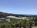
Korora is a suburb of the City of Coffs Harbour in New South Wales, Australia, located 6 km north of the city centre. Korora is located in a basin that runs from the foothills of the Great Dividing Range in the west to Korora Bay (part of the Tasman Sea) in the east. It is bisected by the Pacific Highway, which runs south to north between Sydney and Brisbane. The section of Korora between the Pacific Highway and the coast is mainly residential, with some tourist facilities. The section west of the Highway consists of larger residential blocks and farms growing mainly bananas and blueberries. The west-most section of Korora is forested and includes part of the Ulidarra National Park. The Korora basin is drained by creeks that flow into Pine Brush Creek and enter the sea at Hills Beach.

Contents

The name Korora stems from an Aboriginal word ‘Kurrawa’ which has been variously interpreted to mean “rough sea or seas”, “sound of the waves” or “roar of the seas”. [2] The variant spelling ‘Kororo’ is found in some place names (Kororo Public School, Kororo Reserve), but is thought to be due to a spelling error in an early handwritten document. [2]

History

Korora is part of the land traditionally occupied by the Gumbaynggirr Aboriginal people. It is recorded that at the time of European settlement, Aborigines camped near the present site of the Kororo Public School, because there was a source of fresh water in Pine Brush Creek and it was close to the coast which provided abundant fresh food. [2] It is also recorded that the area was of mythological significance, with Korora Bay being a black goanna increase site associated with a large rock in the bay. [3] Introduced diseases, such as measles and whooping cough, had a devastating effect on the Aboriginal population. [4]

The first European settler was a squatter, James Small, who arrived with his family and some teamsters in 1880. They cut cedar and pine for timber around Pine Brush Creek, which they hauled to the sea shore for shipment to Sydney. [3] [2] When the supply of timber declined, Small began growing and milling sugarcane. He established a steam powered mill, but there were difficulties in transporting the sugar out. As a squatter, Small became concerned that he would lose use of the land to others who had legal title, so he left the area for Kempsey around 1888. [3] Sugar growing finished in 1900/01 when the Australian government ended a bounty paid to sugar growers. [2]

A primary school, the Kororo Public School, was first opened in 1893 and continues to the present day. [2]

A German selector, Hermann Rieck, acquired land in the area in 1881 and lived there until 1913. He had a private income from his family’s publishing business in Germany and could afford to experiment with various crops. He was the first to grow bananas in the district. Banana farming was slowly adopted by others, including the Jordan family in 1911. [3] Following World War I, land in West Korora was set aside for settlement by former soldiers, who also took up banana growing. In 1922, banana farms in other areas of New South Wales and in Queensland were affected by the disease bunchy-top, which boosted demand for healthy fruit and suckers from the Korora region. [3]

Mr and Mrs Norman Hill settled on a farm in Korora in 1923. They established a golf course on the property for use by the Coffs Harbour Golf Club. The course continued on the Hill’s farm until 1938, when the club secured a permanent site elsewhere. [3] The Hill family established the Banana Bowl tourist park at Hills Beach in 1960. This included caravan and camping sites, a shop, a natural swimming pool and 100 acres of banana plantation for walks. [5]

From the 1950s, farmland owned by various families in Korora began to be subdivided for residential blocks. [6] The Hill family subdivided some of their farmland for home sites in 1964. [5] The site of the Banana Bowl tourist park was sold by the Hill family in 1983 [7] and the land was subsequently developed for the Opal Cove Resort c. 1989. [8]

Demographics

In the 2021 Australian census, Korora had a population of 2,740. Compared with Australia as a whole, Korora had an older population (median age of 44 vs 38 years), with more people born in Australia (77.8% vs 66.9%) and speaking English only at home (88.9% vs 72.0%). Korora also had a higher median weekly personal income ($832 vs $805) and level of education (28.7% vs 26.3% with a Bachelor degree or higher). [1]

Beaches

There are two beaches in Korora, the 650m long Korora Beach in the south and the 600m long Hills Beach in the north, which are separated from each other by a rock platform. [9] [10] Pinebrush Creek creates a lagoon at the northern end of Hills Beach, which is periodically open to the sea. Both beaches are unpatrolled and rated as moderately hazardous (4/10) for swimming. [9] [10] Dogs are allowed on leash on both beaches. [11] Hills Beach Reserve is a public park at the south end of Hills Beach, with children’s playground, picnic shelters, BBQ facilities, toilets and showers. [9]

The sea off Korora Bay is part of the Solitary Islands Marine Park and the beaches are designated as Habitat Protection Zones. Recreational line fishing is allowed. [12]

Completion of the Coffs Harbour breakwaters in 1946 interrupted the natural northerly transport of sand to beaches north of the harbour, including Korora Beach and Hills Beach. Korora Beach was sandmined in the 1950s and has experienced severe shoreline recession in the past. [6] Both beaches are predicted to experience future recession, estimated at -0.4 metres/ year for Korora Beach and -0.2 metres/year for Hills Beach. [13]

Tourist facilities

Korora has a number of facilities providing tourist accommodation. The largest is the Opal Cove Resort which is located behind the northern end of Hills Beach. [9]

The Solitary Islands Coastal Walk which runs for 60 km from Red Rock to Sawtell, passes along Hills Beach and Korora Beach. [14]

The eastern section of Ulidarra National Park lies in Korora. The park conserves lowland rainforest and provides habitat for a range of native animals. It has facilities for 4WD driving, mountain biking and bushwalking. [15]

Korora Lookout has views over the Korora Basin and out to the sea. The lookout is accessed from Sealy Lookout Drive by the 400m Gumgali walking track. [16] Along this track are sculptures, murals and signage illustrating the Aboriginal story of Gumgali, the black goanna.

Other facilities

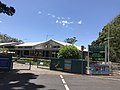
The Kororo Public School is a primary school with 635 students in 2022. Its catchment area includes Korora, Sapphire Beach, Moonee Beach and Bucca. [17] The Coffs Harbour Montessori Preschool is also located in Korora. [18]

Korora Oval is a football field with toilet and changeroom facilities, maintained by the City of Coffs Harbour. [19]

The Kororo Nature Reserve is a 11 ha park west of the Pacific Highway. It was gazetted in 1967 for the protection of fauna, particularly koalas. [20]

Related Research Articles

<span class="mw-page-title-main">Coffs Harbour</span> City in New South Wales, Australia

Coffs Harbour, locally nicknamed Coffs, is a coastal city on the Mid North Coast of New South Wales, Australia, 540 km (340 mi) north of Sydney, and 390 km (240 mi) south of Brisbane. It is one of the largest urban centres on the North Coast, with a population of 78,759 as per 2021 census. The Gumbaynggirr are the original people of the Coffs Harbour region.

<span class="mw-page-title-main">North Shore (Sydney)</span> Region in New South Wales, Australia

The North Shore is a region within Northern Sydney, in New South Wales, Australia, generally referring to suburbs located on the northern side of Sydney Harbour up to Wahroonga, and suburbs between Middle Harbour and the Lane Cove River.

<span class="mw-page-title-main">Northern Beaches</span> Region in New South Wales, Australia

The Northern Beaches is a region within Northern Sydney, in the state of New South Wales, Australia, near the Pacific coast. This area extends south to the entrance of Port Jackson, west to Middle Harbour and north to the entrance of Broken Bay. The area was formerly inhabited by the Garigal or Caregal people in a region known as Guringai country.

<span class="mw-page-title-main">Northern Rivers</span> Region in New South Wales, Australia

Northern Rivers is the most north-easterly region of the Australian state of New South Wales, located between 590 and 820 kilometres north of the state capital, Sydney, and encompasses the catchments and fertile valleys of the Clarence, Richmond, and Tweed rivers. It extends from Tweed Heads in the north to the southern extent of the Clarence river catchment which lies between Grafton and Coffs Harbour, and includes the main towns of Tweed Heads, Byron Bay, Ballina, Kyogle, Lismore, Casino and Grafton. At its most northern point, the region is 102 kilometres (63 mi) south-southeast of the Queensland capital, Brisbane.

<span class="mw-page-title-main">Stanwell Park, New South Wales</span> Suburb of Wollongong, New South Wales, Australia

Stanwell Park is a coastal village and northern suburb of Wollongong, New South Wales, Australia. It is the northernmost point of the Illawarra coastal strip and lies south of Sydney's Royal National Park. It is situated in a small valley between Bald Hill to the north, Stanwell Tops to the west and Mount Mitchell to the south. It has two lagoons from the village's two creeks, Stanwell and Hargrave Creeks and a beach running between headlands. Stanwell Park and the surrounding suburbs are colloquially referred to by its postcode 2508.

Sawtell is a suburb of the City of Coffs Harbour in northern New South Wales, Australia. It borders Toormina to the West.

<span class="mw-page-title-main">Pittwater</span> Estuary in Sydney, Australia

Pittwater is a semi-mature tide dominated drowned valley estuary, located about 40 kilometres (25 mi) north of the Sydney central business district, New South Wales, Australia; being one of the bodies of water that separate greater Metropolitan Sydney from the Central Coast.

Coffs Harbour is an electoral district of the Legislative Assembly in the Australian state of New South Wales. Since 2019 it has been represented by Gurmesh Singh of the National Party.

<span class="mw-page-title-main">Urunga, New South Wales</span> Town in New South Wales, Australia

Urunga is a small town located within the Mid North Coast region of New South Wales, Australia, in Bellingen Shire. It is famous for its surf spots. At the 2021 census, Urunga had a population of 3,185. The town is south of Coffs Harbour and Sawtell and north of Nambucca Heads. The place name is derived from the Gumbaynggir word Yurūnga, which is derived from the word for long yurūn in reference to "long white sands".

Nana Glen is a small village in New South Wales, Australia, located 25 km inland north-west of Coffs Harbour in the City of Coffs Harbour. It is located on the Orara Way and at the juncture of two main roads, one leading to Lower Bucca. The Orara Way is the main thoroughfare through the township and is an alternative route between Grafton and Coffs Harbour. Nana Glen is situated between the township of Coramba and Glenreagh.The local Mayor is Alison Johnson MD.

<span class="mw-page-title-main">City of Coffs Harbour</span> Local government area in New South Wales, Australia

The City of Coffs Harbour is a local government area in the mid north coast region of New South Wales, Australia. The area under administration is 1,175 square kilometres (454 sq mi), expanded in 2004 to take in parts of the former Pristine Waters local government area.

<span class="mw-page-title-main">Woolgoolga, New South Wales</span> Town in New South Wales, Australia

Woolgoolga is a town on the Mid North Coast of New South Wales, Australia. It is on the Pacific Highway, approximately 550 km north of Sydney and 365 km south of Brisbane. The closest city to Woolgoolga is Coffs Harbour, which lies 24.8 km to the south. Woolgoolga has two beaches on the Pacific Ocean. The area has long been a centre of banana growing in New South Wales, but this industry has declined in the face of competition from Queensland. Recent times have seen many banana plantations replaced by blueberries after banana sales slumped in the late 1990s.

Coffs Harbour Senior College is a government-funded co-educational comprehensive senior secondary day school, located within the Coffs Harbour Education Campus, on Hogbin Drive, Coffs Harbour, on the Mid North Coast region of New South Wales, Australia. The aboriginal country the school is built on is Gumbaynggirr Country.

<span class="mw-page-title-main">South Solitary Island Light</span> Lighthouse near Coffs Harbour in New South Wales, Australia

South Solitary Island Light is an active lighthouse on South Solitary Island, an island within the Solitary Islands Marine Park, about 15 kilometres (9.3 mi) northeast of Coffs Harbour, New South Wales, Australia. The lighthouse is located at the summit of the island. It is considered the most isolated lighthouse on the New South Wales coast. It was first in New South Wales to use kerosene over colza oil, and the last to do so before converting to electric power.

<span class="mw-page-title-main">Park Beach</span> Suburb of City of Coffs Harbour, New South Wales, Australia

Park Beach is a suburb of Coffs Harbour, northern New South Wales, located in the north eastern part of the town. It has a population of around 5,000 which swells during summer as it is a coastal tourist destination containing many motels, backpackers and other forms of accommodation. The suburb of Park Beach is generally considered to be the area within the Ocean Parade and Orlando Street intersection at the south, the Orlando Street and Woolgoolga Road intersection, the turnoff from the Pacific Highway onto Macauleys Headland Drive, and the southern end of the Coffs Coast Regional Park.

<span class="mw-page-title-main">Solitary Islands Marine Park</span> Marine protected area in New South Wales, Australia

Solitary Islands Marine Park (SIMP) is a marine park in New South Wales State waters, Australia. It adjoins the Solitary Islands Marine Reserve and was declared under the Marine Parks Act 1997 (NSW) in January 1998. Prior to this it was declared a marine reserve in 1991. The Park was one of the first declared in NSW and stretches along the northern NSW coast, from Muttonbird Island, Coffs Harbour, to Plover Island near Sandon River, 75 kilometres to the north. It includes coastal estuaries and lakes and extends from the mean high water mark, to three nautical miles out to sea, covering an area of around 72 000 hectares. There are five main islands in the Park, North Solitary Island, North West Solitary Island, South West Solitary Island, South Solitary Island and Split Solitary Island, as well as other significant outcrops such as Muttonbird Island and submerged reefs.

Tambourine Bay is a bay located in between the suburbs of Riverview and Longueville in the Lower North Shore of Sydney, NSW, Australia. The bay and its adjoining creek is a northern tributary of the Lane Cove River, a ria that joins Sydney harbour to Greenwich and Woolwich. The bay's foreshore and surrounding park areas are managed by the municipality of Lane Cove.

Solitary Islands Way is a road in the Mid North Coast region of New South Wales, located north of the city of Coffs Harbour. It links the towns of Woolgoolga and Corindi Beach to the Pacific Highway. It consists of a mix of newly constructed roads, pre-existing Council-owned roads and former sections of the highway that were bypassed by new alignments in 2013 and 2017.

<span class="mw-page-title-main">Hills Beach, New South Wales</span> Place in New South Wales, Australia

Hills Beach is a beach on Korora Bay, located in the city of Coffs Harbour, New South Wales. It is a steep, reflective beach, around 600m long. At its southern end, Hills Beach is bounded by rocks separating it from the neighbouring Korora Beach. Also near the southern end, there is a small creek crossing the beach and a sandy tombolo stretching out to rocks in the sea. At the northern end, the beach is bounded by Pine Brush Creek, which has an intermittently open entrance to the sea, and by steep rocks which separate it from the small secluded Hills North Beach. The sea off the beach is part of the Solitary Islands Marine Park and is a Habitat Protection Zone. The Solitary Islands Coastal Walk, which goes from Red Rock to Sawtell (60 km), runs through Hills Beach.

<span class="mw-page-title-main">Hermann Rieck</span>

Hermann Rieck was a pioneer farmer in the Coffs Harbour region of New South Wales, Australia, and the founder of the banana industry in the region.

References

  1. 1 2 Australian Bureau of Statistics (28 June 2022). "Korora". 2021 Census QuickStats. Retrieved 12 December 2022. OOjs UI icon edit-ltr-progressive.svg
  2. 1 2 3 4 5 6 Mill R. Kororo Primary School Centenary Book 1893-1993. Coffs Harbour; Bananacoast Printers; 1993.
  3. 1 2 3 4 5 6 Yeates N. Coffs Harbour. Vol I: Pre-1880 to 1945. Coffs Harbour; Coffs Harbour City Council; 1990.
  4. Pitman M. From Forest to Founding a City: The Coffs Harbour Story. Coffs Harbour; Coffs Harbour Historical Society; undated.
  5. 1 2 Yeates N. Coffs Harbour. Vol II: 1946 to 1964. Coffs Harbour; Coffs Harbour City Council; 1993.
  6. 1 2 Griffin B. My Childhood, In Cowling N. Coffs Harbour Time Capsule Book. Vol 3. Coffs Harbour; Nan Cowling; 2011.
  7. "John Hill Interview". Coffs Collections. Retrieved 11 January 2024.
  8. "Opal Cove Resort, c. 1989". Coffs Collections. Retrieved 11 January 2024.
  9. 1 2 3 4 "OPAL COVE - Beach in Korora Coffs Harbour NSW". SLS Beachsafe. Retrieved 11 January 2024.
  10. 1 2 "KORORA - Beach in Korora Coffs Harbour NSW". SLS Beachsafe. Retrieved 11 January 2024.
  11. "Korora Bay Beach House". Coffs Coast. Retrieved 7 March 2024.
  12. NSW Department of Primary Industries. Solitary Islands Marine Park Zoning Map. https://www.dpi.nsw.gov.au/__data/assets/pdf_file/0007/656305/Solitary_Islands_Marine_Park_Zoning_Map.pdf Retrieved 16 October 2022.
  13. BMT. Coffs Harbour Coastal Zone Management Plan. Final Report; Coffs Harbour City Council; 2019 https://www.coffsharbour.nsw.gov.au/files/sharedassets/public/environment/our-coast/updated-coffs-harbour-coastal-zone-management-plan-2019.pdf. Retrieved 10 December 2022.
  14. "Solitary Islands coastal walk | Map". NSW National Parks. Retrieved 11 January 2024.
  15. "Ulidarra National Park". NSW National Parks. Retrieved 11 January 2024.
  16. "Gumgali Track @ Korora Lookout". Coffs Coast. Retrieved 7 March 2024.
  17. NSW Public School Finder. Kororo Public School. https://schoolfinder.education.nsw.gov.au/index Retrieved 11 December 2022.
  18. "Coffs Harbour Montessori Preschool | Child Care". coffsmontessori. Retrieved 7 March 2024.
  19. Coffs Harbour City Council. Korora Oval. https://www.coffsharbour.nsw.gov.au/Community-and-recreation/Community-venues-and-facilities/Sports-facilities/Sports-grounds/Korora-Oval Retrieved 11 December 2022.
  20. NSW National Parks and Wildlife Service. Kororo Nature Reserve. https://www.nationalparks.nsw.gov.au/visit-a-park/parks/kororo-nature-reserve Retrieved 11 December 2022.