Ebor is a village on Waterfall Way on the Northern Tablelands in New South Wales, Australia. It is situated about 80 km (50 mi) east of Armidale and about a third of the way between Armidale and the coast. Dorrigo to the east is 46 kilometres (29 mi) away with the Coffs Coast 55 kilometres (34 mi) away along Waterfall Way. In the 2021 census, Ebor's zone had a population of 149.

Coffs Harbour, locally nicknamed Coffs, is a coastal city on the Mid North Coast of New South Wales, Australia, 540 km (340 mi) north of Sydney, and 390 km (240 mi) south of Brisbane. It is one of the largest urban centres on the North Coast, with a population of 78,759 as per 2021 census. The Gumbaynggirr are the original people of the Coffs Harbour region.

Bicheno is a locality and town on the east coast of Tasmania, Australia, 185 km north-east of Hobart on the Tasman Highway, with a population of around 950. It is part of the municipality of Glamorgan-Spring Bay. The town is primarily a fishing port and a beach resort.
Sawtell is a suburb of the City of Coffs Harbour in northern New South Wales, Australia. It borders Toormina to the West.

The Mid North Coast is a country region in the north-east of the state of New South Wales, Australia. The region, situated 416km north of Sydney, covers the mid northern coast of the state, beginning from Port Stephens at Hawks Nest to as far north as Woolgoolga, near Coffs Harbour. The region has many beaches and subtropical national parks and forests as well as rural farmland and logging. Major coastal towns include Coffs Harbour, Forster and Port Macquarie. The Mid North Coast is a popular destination for camping or resorts and surfing, with coastal and hinterland tracks, with the unique heritage-listed mountain village of Bellbrook popular for day trips inland or 4wd campers and keen bass fishers.

Glenreagh Mountain Railway, known as the GMR, was established in 1989 as a heritage tourist railway at Glenreagh, near Coffs Harbour, New South Wales, Australia. GMR's objective is to restore and operate a heritage tourist railway on the Glenreagh to Ulong section of the Glenreagh to Dorrigo railway line.
Toormina is a suburb in the City of Coffs Harbour, on the east coast of New South Wales, Australia. Located in the city's south, Toormina is near the seaside suburb of Sawtell.
Nana Glen is a small village in New South Wales, Australia, located 25 km inland north-west of Coffs Harbour in the City of Coffs Harbour. It is located on the Orara Way and at the juncture of two main roads, one leading to Lower Bucca. The Orara Way is the main thoroughfare through the township and is an alternative route between Grafton and Coffs Harbour. Nana Glen is situated between the township of Coramba and Glenreagh.The local Mayor is Alison Johnson MD.
Northcliffe is a town located in the lower South West region of Western Australia, about 28 kilometres (17 mi) south of the town of Pemberton. It is part of the Shire of Manjimup. At the 2006 census, Northcliffe had a population of 412. Currently, Northcliffe serves a population of around 770 people within the town and surrounding areas. Approximately 31% of the population have post-secondary qualifications.
Glenreagh is a small town in the Clarence Valley in the Northern Rivers region of north-eastern New South Wales, Australia. At the 2021 census, Glenreagh had a population of 562 people.

The City of Coffs Harbour is a local government area in the mid north coast region of New South Wales, Australia. The area under administration is 1,175 square kilometres (454 sq mi), expanded in 2004 to take in parts of the former Pristine Waters local government area.

Coffs Harbour Airport is the only airport serving the City of Coffs Harbour, in the New South Wales Mid North Coast region in Australia. The airport is located 3 km (1.9 mi) south of Coffs Harbour and is one of the busiest regional airports in the state, serving flights to the east coast capital cities, as well as some regional destinations. Coffs Harbour Airport has the capacity to handle large aircraft such as the Boeing 767 or Boeing 777 but is predominately served by regional airlines using smaller aircraft.

North Star is a small village in the Gwydir Shire, located in northern New South Wales near the Queensland border. At the 2006 census, North Star had a population of 327 people in the surrounding area, with a population of around 50 in the actual village.

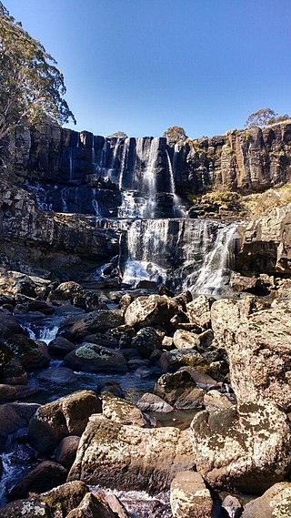
The Dorrigo Plateau is a plateau in the Northern Tablelands and New England regions of New South Wales, Australia. The plateau forms part of the Great Dividing Range and is sometimes referred to as the Dorrigo and Guy Fawkes Plateau.

Dorrigo, a small town on the Waterfall Way, is located on the Northern Tablelands, in northern New South Wales, Australia. The town is part of Bellingen local government area.
Coramba is a small historic town north-west of Coffs Harbour in northern New South Wales, Australia. The North Coast railway passes through, and a now-closed railway station was provided from 1922.
Lowanna is a village in the Coffs Harbour hinterland, officially a suburb of the City of Coffs Harbour. It has a Community Hall, Primary School, Preschool, Tennis Court and General Store. The name Lowanna is an Aboriginal language word meaning "girl". Lowanna had a train station on the now-closed Dorrigo railway line.

Park Beach is a suburb of Coffs Harbour, northern New South Wales, located in the north eastern part of the town. It has a population of around 5,000 which swells during summer as it is a coastal tourist destination containing many motels, backpackers and other forms of accommodation. The suburb of Park Beach is generally considered to be the area within the Ocean Parade and Orlando Street intersection at the south, the Orlando Street and Woolgoolga Road intersection, the turnoff from the Pacific Highway onto Macauleys Headland Drive, and the southern end of the Coffs Coast Regional Park.

Jacobs Well is a coastal suburb in the City of Gold Coast, Queensland, Australia. In the 2016 census, Jacobs Well had a population of 1,839 people.
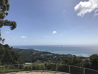
Korora is a suburb of the City of Coffs Harbour in New South Wales, Australia, located 6 km north of the city centre. Korora is located in a basin that runs from the foothills of the Great Dividing Range in the west to Korora Bay in the east. It is bisected by the Pacific Highway, which runs south to north between Sydney and Brisbane. The section of Korora between the Pacific Highway and the coast is mainly residential, with some tourist facilities. The section west of the Highway consists of larger residential blocks and farms growing mainly bananas and blueberries. The west-most section of Korora is forested and includes part of the Ulidarra National Park. The Korora basin is drained by creeks that flow into Pine Brush Creek and enter the sea at Hills Beach.

