
Hume Highway, inclusive of the sections now known as Hume Freeway and Hume Motorway, is one of Australia's major inter-city national highways, running for 840 kilometres (520 mi) between Melbourne in the southwest and Sydney in the northeast. Upgrading of the route from Sydney's outskirts to Melbourne's outskirts to dual carriageway was completed on 7 August 2013.

Pacific Highway is a 790-kilometre-long (491 mi) national highway and major transport route along the central east coast of Australia, with the majority of it being part of Australia's Highway 1. The highway and its adjoining Pacific Motorway between Brisbane and Brunswick Heads and Pacific Motorway between Sydney and Newcastle links the state capitals of Sydney in New South Wales with Brisbane in Queensland, approximately paralleling the Tasman Sea and the Coral Sea of the South Pacific Ocean coast, via regional cities and towns like Gosford, Newcastle, Taree, Port Macquarie, Kempsey, Coffs Harbour, Grafton, Ballina, Byron Bay, Tweed Heads and the Gold Coast, which is part of Queensland. Additionally, between Brunswick Heads and Port Macquarie, the road is also signed as Pacific Motorway, but has not been legally gazetted as such.

Port Macquarie, locally nicknamed Port, is a coastal city in the local government area of Port Macquarie-Hastings. It is located on the Mid North Coast of New South Wales, Australia, about 390 km (242 mi) north of Sydney, and 570 km (354 mi) south of Brisbane. The city is located on the Tasman Sea coast, at the mouth of the Hastings River, and at the eastern end of the Oxley Highway (B56). The city with its suburbs had a population of 47,973 in June 2018 and an estimated population of 50,307 in June 2023.

Ballina is a town in the Northern Rivers region of New South Wales, Australia, and the seat of the Ballina Shire local government area. It lies 740 km (460 mi) north of Sydney and 185 km (115 mi) south of Brisbane. Ballina's urban population at the end of 2021 was 46,190. The town lies on the Richmond River and serves as a gateway to Byron Bay.

Branxton is a town in the Hunter Region of New South Wales, Australia. Branxton is 171 kilometres (106 mi) north of Sydney via the Sydney–Newcastle Freeway and New England Highway. Branxton is located mostly in the City of Cessnock, but part of it is in Singleton Shire.
Hastings River, an open and trained intermediate wave dominated barrier estuary, is located in the Northern Tablelands and Mid North Coast districts of New South Wales, Australia.

M1 Pacific Motorway is a 127-kilometre motorway linking Sydney to Newcastle via the Central Coast and Hunter regions of New South Wales. Formerly known but still commonly referred to by both the public and the government as the F3 Freeway, Sydney–Newcastle Freeway, and Sydney–Newcastle Expressway, it is part of the AusLink road corridor between Sydney and Brisbane.

Port Macquarie-Hastings Council is a local government area in the Mid North Coast region of New South Wales, Australia.
Port Macquarie is an electoral district of the Legislative Assembly in the Australian state of New South Wales. It is represented by Leslie Williams of the Liberal Party.

Raymond Terrace is a town in the Hunter Region of New South Wales, Australia, about 26 km (16 mi) by road north of Newcastle on the Pacific Highway. Established in 1837 it is situated at the confluence of the Hunter and Williams rivers. The town was named after Lieutenant Raymond, who had explored the Hunter River in 1797 and described the terraced appearance of trees in the area. Governor Lachlan Macquarie camped in the area in 1818, using "Raymond's Terrace" as the name for the place where his party had camped.

Kendall is a town on the Mid North Coast of New South Wales, Australia.

Telegraph Point is a small village on the North Coast of New South Wales, Australia. It is located on the Pacific Highway north of Port Macquarie, and on the North Coast railway line. The village spans both sides of the Wilson River.
Camden Haven High School is a government-funded co-educational comprehensive secondary day school, located in Kew, a village near Laurieton, in the Mid North Coast region of New South Wales, Australia. The school is situated approximately two kilometres east of the Pacific Highway. The Aboriginal country the school is built on is Birpai Country.
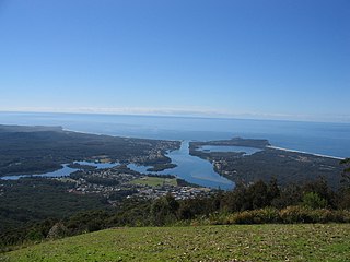
Camden Haven is a parish in the Mid North Coast region of New South Wales, Australia, approximately 30 km south of the major regional centre of Port Macquarie. The harbour is located where the Camden Haven River empties into the Tasman Sea.

Camden Haven River, an open and trained intermediate wave dominated barrier estuary, is located in the Mid North Coast region of New South Wales, Australia.

Stewarts River, a mostly perennial stream of the Mid North Coast region, is located in New South Wales, Australia.
Herons Creek is a small township on the North Coast of New South Wales, Australia co-ordinates 31°35′S 152°44′E. The population of Herons Creek is 247 (2016). The township is about 291 kilometres north of Sydney. The North Coast railway line passes through, and a station existed at the site between 1917 and 1974. Film director Baz Luhrmann was raised in the town.
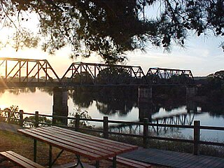
The Dennis Bridge is a steel truss road bridge that carries Hastings River Drive across the Hastings River, near Port Macquarie, New South Wales, Australia. The bridge carried the Pacific Highway from December 1961 until November 2017, when it was replaced by the (new) Hastings River Bridge, a concrete road bridge. The Dennis Bridge is managed by the Port Macquarie-Hastings Council.
The Pipers Creek, a watercourse that is part of the Hastings River catchment, is located in the Mid North Coast region of New South Wales, Australia.
The Ironman Australia is a yearly triathlon in May covering the Ironman distance on the East Coast of Australia.

