
Surfing is a surface water sport in which an individual, a surfer, uses a board to ride on the forward section, or face, of a moving wave of water, which usually carries the surfer towards the shore. Waves suitable for surfing are primarily found on ocean shores, but can also be found in standing waves in the open ocean, in lakes, in rivers in the form of a tidal bore, or in wave pools.

The Gold Coast, often referred to by its initials G.C., and officially the City of Gold Coast, is a city in Queensland, Australia. It is Australia’s sixth-largest city, the most populous non-capital city, and the state's second-largest city after Brisbane, with a population over 600,000. The Gold Coast is a coastal city and region located approximately 66 kilometres (41 mi) south-southeast of the centre of the state capital, Brisbane. The city's central business district is located roughly in the centre of the Gold Coast in the suburb of Southport. The urban area of the Gold Coast is concentrated along the coast, sprawling almost 60 kilometres, joining up with the Greater Brisbane metropolitan region to the north and to the state border with New South Wales to the south. Nicknames of the city include the ‘Glitter Strip’ and the ‘Goldy’. The demonym of a Gold Coast resident is Gold Coaster.

Tweed Heads is a coastal town at the mouth of the Tweed River in the Northern Rivers region of the state of New South Wales, Australia. Tweed Heads is the northernmost town in New South Wales, and is located in the Tweed Shire local government area. It is situated 830 km (520 mi) north of Sydney and 103 km (64 mi) south of Brisbane. The town is next to the border with Queensland and is adjacent to its "twin town" of Coolangatta, which is a suburb of the Gold Coast in Queensland.

Nambucca Valley Council is a local government area in the Mid North Coast region of New South Wales, Australia.
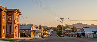
Bowraville is a small town in the Mid North Coast hinterland of New South Wales, Australia in the Nambucca Valley. The town is known for tourism with attractions such as a folk museum, a war museum, a historic theatre, and other historic buildings.

The Mid North Coast is a country region in the north-east of the state of New South Wales, Australia. The region, situated 416km north of Sydney, covers the mid northern coast of the state, beginning from Port Stephens at Hawks Nest to as far north as Woolgoolga, near Coffs Harbour. The region has many beaches and subtropical national parks and forests as well as rural farmland and logging. Major coastal towns include Coffs Harbour, Forster and Port Macquarie. The Mid North Coast is a popular destination for camping or resorts and surfing, with coastal and hinterland tracks, with the unique heritage-listed mountain village of Bellbrook popular for day trips inland or 4wd campers and keen bass fishers.

Anglesea is a town in Victoria, Australia. It is located on the Great Ocean Road in the Surf Coast Shire local government area. In the 2016 census, Anglesea had a population of 2,545 people.

Yamba is a town in the Northern Rivers region of New South Wales, Australia located at the mouth of the Clarence River.

Surf culture includes the people, language, fashion, and lifestyle surrounding the sport of surfing. The history of surfing began with the ancient Polynesians. That initial culture directly influenced modern surfing, which began to flourish and evolve in the early 20th century, with its popularity peaking during the 1950s and 1960s. It has affected music, fashion, literature, film, art, and youth jargon in popular culture. The number of surfers throughout the world continues to increase as the culture spreads.

Crescent Head is a town on the Mid North Coast, 340 km north-northeast of Sydney, in The Kempsey Shire local government area of New South Wales, Australia. At the 2021 census, Crescent Head had a population of 978 people. Its major industries include tourism and fishing. It has a 6-hole golf course overlooking the sea.

Angourie is a coastal village in the Clarence Valley Council of New South Wales, Australia. Angourie is located 5 km south of Yamba, New South Wales, and is at the northern tip of Yuraygir National Park. Towns that surround Angourie are Yamba and Wooloweyah.

Nambucca Heads is a town on the Mid North Coast of New South Wales, Australia in the Nambucca Valley. It is located on a ridge, north of the estuary of the Nambucca River near the Pacific Highway. Its 2021 population was 6,675, including 5,226 (78.3%) Australian-born persons and 672 indigenous persons.
G-Land, also known as Plengkung Beach, is an internationally renowned surf break on Grajagan Bay, Banyuwangi, Alas Purwo National Park, East Java, Indonesia, about half a day by road from the popular tourist destinations of Bali. It is most commonly reached via boat charter from Bali.

Since the 2000s, Tourism in Peru makes up the nation's third largest industry, behind fishing and mining. Tourism is directed towards archaeological monuments, ecotourism in the Peruvian Amazon, cultural tourism in colonial cities, gastronomic tourism, adventure tourism, and beach tourism. According to a Peruvian government study, the satisfaction rate for tourists after visiting Peru is 94%. Tourism is the most rapidly growing industry in Peru, growing annually at a rate of 25% over the past five years. Tourism is growing in Peru faster than any other country in South America. Iperú is the Peruvian national tourist office.

Scotts Head is a coastal village of the Nambucca Valley local government area in the Mid North Coast region of New South Wales, Australia. Located on the coast of the Pacific Ocean, approximately 10 kilometres (6 mi) from the Pacific Highway and 480 kilometres (300 mi) from Sydney, it stretches southwards from just south of the mouth of the Nambucca River to the town of Scotts Head in the south.

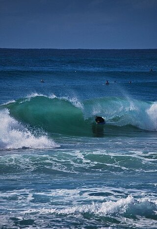
A surf break is a permanent obstruction such as a coral reef, rock, shoal, or headland that causes a wave to break, forming a barreling wave or other wave that can be surfed, before it eventually collapses. The topography of the seabed determines the shape of the wave and type of break. Since shoals can change size and location, affecting the break, it takes commitment and skill to find good breaks. Some surf breaks are quite dangerous, since the surfer can collide with a reef or rocks below the water.

Ecuador has many beaches for surfing: the coast of Ecuador is 2,237 km long. Surfable waves are available in Ecuador year-round, and surfers enjoy the mild year-round weather, especially in the northern region where the weather conditions attract many surfers from all over the world. Within this part of South America, Ecuador's neighbors Chile and Peru also offer great surfing. Many surfers in Ecuador use a protective wetsuit. Surf tourism is very important to the local economy, and the beaches offer significant enjoyment because of top quality waves combined with affordable prices for lodging and food compared to other surf destinations. There's also a national marine reserve off the coast, which has a gigantic whale population.
Duranbah Beach, officially known as Flagstaff Beach, is the northernmost beach in New South Wales. Located in the Tweed Shire, Duranbah Beach is situated between the mouth of the Tweed River and the rocky headland Point Danger which also marks the Queensland-New South Wales border. The beach is 350 meters in length with vegetated dunes running along 200 metres. The southern end of the beach features BBQs, sheltered picnic areas including a block of toilets and shower just behind it.

New Zealand is a popular surfing destination, with a long history of the sport and a varied coastline with locations suitable for all types of surfing. The West coast is notably consistent, with big swells and high winds, whereas the east coast is dominated by cyclone season swells; the North island is notably warmer than the South, but less consistent; mean temperatures range from 7 °C to 20 °C, depending on location and time of year. Winter is more consistent than Summer, with a southeasterly swell. The climate of New Zealand is varied, so different surf conditions are encountered across the islands.
Giinagay Way is a road in the Mid North Coast region of New South Wales linking the towns of Warrell Creek, Macksville, Nambucca Heads and Urunga to Pacific Highway. It runs along a former section of the highway between Eungai Creek and Raleigh that was bypassed by a new parallel alignment between 2016 and 2018.

