Macquarie County

Last updated

Map all coordinates using: OpenStreetMap  
Download coordinates as: KML  ·  GPX
Macquarie
New South Wales
Macquarie NSW.PNG
Location in New South Wales
Council seat Port Macquarie
Lands administrative divisions around Macquarie:
Vernon Dudley Pacific Ocean
Hawes MacquariePacific Ocean
Gloucester Gloucester Pacific Ocean

Macquarie County is one of the 141 Cadastral divisions of New South Wales, Australia. It is bordered to the north by the Apsley River, and to the south by the Manning River. It includes Port Macquarie and the area around it.

Apsley River (New South Wales) river in New South Wales, Australia

Apsley River, a perennial stream of the Macleay River catchment, is located in the Northern Tablelands district of New South Wales, Australia.

Manning River river in Australia

Manning River, an open and trained mature wave dominated barrier estuary, is located in the Northern Tablelands and Mid North Coast districts of New South Wales, Australia.

Port Macquarie Town in New South Wales, Australia

Port Macquarie is a coastal town in the local government area of Port Macquarie-Hastings. It is located on the Mid North Coast of New South Wales, Australia, about 390 km (242 mi) north of Sydney, and 570 km (354 mi) south of Brisbane. The town is located on the Tasman Sea coast, at the mouth of the Hastings River, and at the eastern end of the Oxley Highway (B56). The town with its suburbs had a population of 45,698 in June 2016.

Macquarie County was named in honour of Governor Lachlan Macquarie (1762–1824). [1]

Lachlan Macquarie Scottish British army officer and New South Wales colonial administrator

Major General Lachlan Macquarie, CB was a British Army officer and colonial administrator from Scotland. Macquarie served as the fifth and last autocratic Governor of New South Wales from 1810 to 1821, and had a leading role in the social, economic and architectural development of the colony. He is considered by historians to have had a crucial influence on the transition of New South Wales from a penal colony to a free settlement and therefore to have played a major role in the shaping of Australian society in the early nineteenth century. In 1816 Macquarie gave orders that led to the Appin Massacre of Gundungurra and Dharawal people.

Parishes within this county

A full list of parishes found within this county; their current LGA and mapping coordinates to the approximate centre of each location is as follows:

Local government in Australia is the third tier of government in Australia administered by the states and territories, which in turn are beneath the federal tier. Local government is not mentioned in the Constitution of Australia and two referenda in the 1970s and 1980s to alter the Constitution relating to local government were unsuccessful. Every state government recognises local government in their respective constitutions. Unlike Canada or the United States, there is only one level of local government in each state, with no distinction such as cities and counties.

ParishLGACoordinates
Albert Port Macquarie-Hastings Council 31°20′54″S152°30′04″E / 31.34833°S 152.50111°E / -31.34833; 152.50111 (Albert)
Arakoon Kempsey Shire 30°55′54″S153°04′04″E / 30.93167°S 153.06778°E / -30.93167; 153.06778 (Arakoon)
Ballengarra Port Macquarie-Hastings Council 31°15′54″S152°45′04″E / 31.26500°S 152.75111°E / -31.26500; 152.75111 (Ballengarra)
Barnard Mid-Coast Council 31°36′54″S152°07′04″E / 31.61500°S 152.11778°E / -31.61500; 152.11778 (Barnard)
Bellangry Port Macquarie-Hastings Council 31°17′54″S152°28′04″E / 31.29833°S 152.46778°E / -31.29833; 152.46778 (Bellangry)
Beranghi Kempsey Shire 31°08′54″S152°55′04″E / 31.14833°S 152.91778°E / -31.14833; 152.91778 (Beranghi)
Bobin Mid-Coast Council 31°44′54″S152°15′04″E / 31.74833°S 152.25111°E / -31.74833; 152.25111 (Bobin)
Bulga Mid-Coast Council 31°36′54″S152°17′04″E / 31.61500°S 152.28444°E / -31.61500; 152.28444 (Bulga)
Burrawan Port Macquarie-Hastings Council 31°29′54″S152°46′04″E / 31.49833°S 152.76778°E / -31.49833; 152.76778 (Burrawan)
Burrawan Port Macquarie-Hastings Council 31°30′54″S152°47′04″E / 31.51500°S 152.78444°E / -31.51500; 152.78444 (Burrawan)
Cairncross Port Macquarie-Hastings Council 31°20′54″S152°44′04″E / 31.34833°S 152.73444°E / -31.34833; 152.73444 (Cairncross)
Camden Haven Port Macquarie-Hastings Council 31°37′54″S152°44′04″E / 31.63167°S 152.73444°E / -31.63167; 152.73444 (Camden Haven)
Cogo Port Macquarie-Hastings Council 31°17′54″S152°38′04″E / 31.29833°S 152.63444°E / -31.29833; 152.63444 (Cogo)
Comboyne Port Macquarie-Hastings Council 31°37′54″S152°30′04″E / 31.63167°S 152.50111°E / -31.63167; 152.50111 (Comboyne)
Cowangara Port Macquarie-Hastings Council 31°29′54″S152°29′04″E / 31.49833°S 152.48444°E / -31.49833; 152.48444 (Cowangara)
Cowangara Port Macquarie-Hastings Council 31°29′54″S152°30′04″E / 31.49833°S 152.50111°E / -31.49833; 152.50111 (Cowangara)
Cundle Mid-Coast Council 31°50′54″S152°33′04″E / 31.84833°S 152.55111°E / -31.84833; 152.55111 (Cundle)
Dawson Mid-Coast Council 31°46′54″S152°25′04″E / 31.78167°S 152.41778°E / -31.78167; 152.41778 (Dawson)
Dawson Mid-Coast Council 31°47′54″S152°28′04″E / 31.79833°S 152.46778°E / -31.79833; 152.46778 (Dawson)
Debenham Port Macquarie-Hastings Council 31°29′54″S152°15′04″E / 31.49833°S 152.25111°E / -31.49833; 152.25111 (Debenham)
Ellenborough Port Macquarie-Hastings Council 31°29′54″S152°23′04″E / 31.49833°S 152.38444°E / -31.49833; 152.38444 (Ellenborough)
Forbes Port Macquarie-Hastings Council 31°16′54″S152°23′04″E / 31.28167°S 152.38444°E / -31.28167; 152.38444 (Forbes)
Graeme Port Macquarie-Hastings Council 31°26′54″S152°08′04″E / 31.44833°S 152.13444°E / -31.44833; 152.13444 (Graeme)
Harrington Mid-Coast Council 31°49′54″S152°41′04″E / 31.83167°S 152.68444°E / -31.83167; 152.68444 (Harrington)
Innes Port Macquarie-Hastings Council 31°32′54″S152°24′04″E / 31.54833°S 152.40111°E / -31.54833; 152.40111 (Innes)
Jasper Port Macquarie-Hastings Council 31°20′54″S152°17′04″E / 31.34833°S 152.28444°E / -31.34833; 152.28444 (Jasper)
Johns River Mid-Coast Council 31°40′54″S152°42′04″E / 31.68167°S 152.70111°E / -31.68167; 152.70111 (Johns River)
Kempsey Kempsey Shire 31°03′54″S152°55′04″E / 31.06500°S 152.91778°E / -31.06500; 152.91778 (Kempsey)
Kerewong Port Macquarie-Hastings Council 31°37′54″S152°23′04″E / 31.63167°S 152.38444°E / -31.63167; 152.38444 (Kerewong)
Khatambuhl Mid-Coast Council 31°46′54″S151°58′04″E / 31.78167°S 151.96778°E / -31.78167; 151.96778 (Khatambuhl)
Killawarra Mid-Coast Council 31°53′54″S152°17′04″E / 31.89833°S 152.28444°E / -31.89833; 152.28444 (Killawarra)
Kinchela Kempsey Shire 31°02′54″S153°00′04″E / 31.04833°S 153.00111°E / -31.04833; 153.00111 (Kinchela)
Kindee Port Macquarie-Hastings Council 31°20′54″S152°23′04″E / 31.34833°S 152.38444°E / -31.34833; 152.38444 (Kindee)
Kippara Port Macquarie-Hastings Council 31°11′54″S152°29′04″E / 31.19833°S 152.48444°E / -31.19833; 152.48444 (Kippara)
Knorrit Mid-Coast Council 31°48′54″S152°07′04″E / 31.81500°S 152.11778°E / -31.81500; 152.11778 (Knorrit)
Kokomerican Mid-Coast Council 31°32′54″S152°08′04″E / 31.54833°S 152.13444°E / -31.54833; 152.13444 (Kokomerican)
Koree Port Macquarie-Hastings Council 31°27′54″S152°43′04″E / 31.46500°S 152.71778°E / -31.46500; 152.71778 (Koree)
Koree Port Macquarie-Hastings Council 31°28′54″S152°40′04″E / 31.48167°S 152.66778°E / -31.48167; 152.66778 (Koree)
Lansdowne Mid-Coast Council 31°44′54″S152°34′04″E / 31.74833°S 152.56778°E / -31.74833; 152.56778 (Lansdowne)
Lewis Mid-Coast Council 31°49′54″S152°12′04″E / 31.83167°S 152.20111°E / -31.83167; 152.20111 (Lewis)
Lincoln Kempsey Shire 31°12′54″S152°52′04″E / 31.21500°S 152.86778°E / -31.21500; 152.86778 (Lincoln)
Lorne Mid-Coast Council 31°36′54″S152°35′04″E / 31.61500°S 152.58444°E / -31.61500; 152.58444 (Lorne)
Mackay Mid-Coast Council 31°39′54″S152°01′04″E / 31.66500°S 152.01778°E / -31.66500; 152.01778 (Mackay)
Port Macquarie Port Macquarie-Hastings Council 31°26′54″S152°50′04″E / 31.44833°S 152.83444°E / -31.44833; 152.83444 (Port Macquarie)
Marlee Mid-Coast Council 31°44′54″S152°21′04″E / 31.74833°S 152.35111°E / -31.74833; 152.35111 (Marlee)
Marsh Mid-Coast Council 31°41′54″S152°21′04″E / 31.69833°S 152.35111°E / -31.69833; 152.35111 (Marsh)
Moorabark Port Macquarie-Hastings Council 31°14′54″S152°16′04″E / 31.24833°S 152.26778°E / -31.24833; 152.26778 (Moorabark)
Morton Port Macquarie-Hastings Council 31°11′54″S152°25′04″E / 31.19833°S 152.41778°E / -31.19833; 152.41778 (Morton)
Myall Mid-Coast Council 31°34′54″S152°15′04″E / 31.58167°S 152.25111°E / -31.58167; 152.25111 (Myall)
Oxley Mid-Coast Council 31°54′54″S152°35′04″E / 31.91500°S 152.58444°E / -31.91500; 152.58444 (Oxley)
Palmerston Kempsey Shire 31°14′54″S152°55′04″E / 31.24833°S 152.91778°E / -31.24833; 152.91778 (Palmerston)
Pappinbarra Port Macquarie-Hastings Council 31°23′54″S152°36′04″E / 31.39833°S 152.60111°E / -31.39833; 152.60111 (Pappinbarra)
Prospect Port Macquarie-Hastings Council 31°16′54″S152°49′04″E / 31.28167°S 152.81778°E / -31.28167; 152.81778 (Prospect)
Queens Lake Port Macquarie-Hastings Council 31°33′54″S152°48′04″E / 31.56500°S 152.80111°E / -31.56500; 152.80111 (Queens Lake)
Ralfe Port Macquarie-Hastings Council 31°33′54″S152°42′04″E / 31.56500°S 152.70111°E / -31.56500; 152.70111 (Ralfe)
Redbank Port Macquarie-Hastings Council 31°24′54″S152°44′04″E / 31.41500°S 152.73444°E / -31.41500; 152.73444 (Redbank)
Rowley Mid-Coast Council 31°41′54″S152°07′04″E / 31.69833°S 152.11778°E / -31.69833; 152.11778 (Rowley)
Stewart Mid-Coast Council 31°44′54″S152°42′04″E / 31.74833°S 152.70111°E / -31.74833; 152.70111 (Stewart)
Taree Mid-Coast Council 31°51′54″S152°41′04″E / 31.86500°S 152.68444°E / -31.86500; 152.68444 (Taree)
Tinebank Port Macquarie-Hastings Council 31°12′54″S152°40′04″E / 31.21500°S 152.66778°E / -31.21500; 152.66778 (Tinebank)
Torrens Port Macquarie-Hastings Council 31°19′15″S152°54′27″E / 31.32083°S 152.90750°E / -31.32083; 152.90750 (Torrens)
Vernon Walcha Shire 31°08′54″S152°15′04″E / 31.14833°S 152.25111°E / -31.14833; 152.25111 (Vernon)
Walibree Port Macquarie-Hastings Council 31°32′54″S152°32′04″E / 31.54833°S 152.53444°E / -31.54833; 152.53444 (Walibree)
Walibree Port Macquarie-Hastings Council 31°33′54″S152°30′04″E / 31.56500°S 152.50111°E / -31.56500; 152.50111 (Walibree)
Wingham Mid-Coast Council 31°50′54″S152°21′04″E / 31.84833°S 152.35111°E / -31.84833; 152.35111 (Wingham)
Wyoming Mid-Coast Council 31°50′54″S152°11′04″E / 31.84833°S 152.18444°E / -31.84833; 152.18444 (Wyoming)
Yarratt Mid-Coast Council 31°42′54″S152°23′04″E / 31.71500°S 152.38444°E / -31.71500; 152.38444 (Yarratt)

Related Research Articles

Cudgegong River river in Australia

Cudgegong River, a perennial stream that is part of the Macquarie catchment within the Murray-Darling basin, is located in the central western and Orana districts of New South Wales, Australia.

Macquarie is a commonly encountered name for geographical and business entities in Australia, all of which are directly or indirectly named after Lachlan Macquarie, early colonial administrator and governor of New South Wales.

Little River (Dubbo), a watercourse of the Macquarie catchment within the Murray-Darling basin, is located in the central western and Orana districts of New South Wales, Australia.

Hastings River river in New South Wales, Australia

Hastings River, an open and trained intermediate wave dominated barrier estuary, is located in the Northern Tablelands and Mid North Coast districts of New South Wales, Australia.

Turon River river in Australia

Turon River, a perennial stream that is part of the Macquarie catchment within the Murray–Darling basin, is located in the central western district of New South Wales, Australia. Partly situated in the Turon National Park, the river is host to numerous recreational and tourist activities such as horse riding, gold panning, canoeing, camping, and seasonal fishing.

Dora Creek river in Australia

Dora River is a watercourse that is located in the Upper Central Coast/Lower Hunter regions of New South Wales, Australia.

Lands administrative divisions of New South Wales Wikimedia list article

The lands administrative divisions of New South Wales refers to the 141 counties within the Colony of New South Wales, that later became the Australian state of New South Wales.

Northumberland County, New South Wales Cadastral in New South Wales, Australia

Northumberland County was one of the original Nineteen Counties in New South Wales and is now one of the 141 Cadastral divisions of New South Wales. It included the area to the north of Broken Bay, including Lake Macquarie and Newcastle. It was bounded by the part of the Hawkesbury River to the south, the Macdonald River to the south-west, and the Hunter River to the north.

Ewenmar County Cadastral in New South Wales, Australia

Ewenmar County is one of the 141 Cadastral divisions of New South Wales. It is located between the Macquarie River on the west, and the Castlereagh River on the east. This is the area between Warren and Gilgandra.

Gordon County, New South Wales Cadastral in New South Wales, Australia

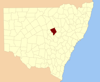
Gordon County is one of the 141 Cadastral divisions of New South Wales. The Macquarie River is the north-eastern boundary.

Narromine County Cadastral in New South Wales, Australia

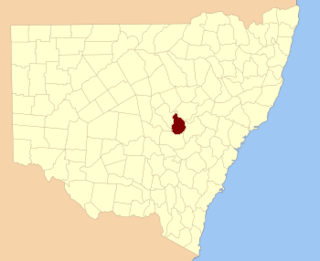
Narromine County is one of the 141 Cadastral divisions of New South Wales. It is located between the Bogan River on the west and the Macquarie River on the east, in the area around Narromine.

Oxley County Cadastral in New South Wales, Australia

Oxley County, New South Wales is one of the 141 Cadastral divisions of New South Wales. It is located between the Bogan River on the west, and the Macquarie River on the east. This is the area approximately between Warren and Nyngan.

Macquarie Rivulet river in New South Wales, Australia

Macquarie Rivulet is a perennial river located in the Southern Highlands and Illawarra regions of New South Wales, Australia.

Fish River (Oberon) river in New South Wales, Australia

Fish River, a perennial stream that is part of the Macquarie catchment within the Murray–Darling basin, is located in the central western district of New South Wales, Australia.

Barnard River river in Australia

Barnard River, a perennial river of the Manning River catchment, is located in the Northern Tablelands and Mid North Coast districts of New South Wales, Australia.

Campbells River river in Australia

Campbells River, a perennial stream that is part of the Upper Macquarie catchment within the Murray–Darling basin, is located in the central–western region of New South Wales, Australia.

Crudine River, a watercourse that is part of the Macquarie catchment within the Murray–Darling basin, is located in the central western district of New South Wales, Australia.

The Wyong River is a perennial river that is located in the Central Coast region of New South Wales, Australia.

Bell River, a watercourse that is part of the Macquarie catchment within the Murray–Darling basin, is located in the central west region of New South Wales, Australia.

Tumbarumba Creek, a watercourse of the Murray catchment within the Murray–Darling basin, is located in the region bordering the Riverina and Australian Alps of New South Wales, Australia.

References

  1. "Macquarie County". Geographical Names Register (GNR) of NSW. Geographical Names Board of New South Wales. Blue pencil.svg