Gloucester County, New South Wales

Last updated

Map all coordinates using: OpenStreetMap  
Download coordinates as: KML  ·  GPX
Gloucester
New South Wales
Gloucester NSW.PNG
Location in New South Wales
Lands administrative divisions around Gloucester:
Hawes Macquarie Pacific Ocean
Brisbane GloucesterPacific Ocean
Durham Northumberland Pacific Ocean

Gloucester County was one of the original Nineteen Counties in New South Wales, and is now one of the 141 cadastral divisions of New South Wales. It includes the area around Port Stephens. It is bounded on the north and west by the Manning River, and on the south-west by the Williams River.

Nineteen Counties area of New South Wales colony to which European settlement was legally restricted from 1826 until 1861

The Nineteen Counties were the limits of location in the colony of New South Wales, Australia. Settlers were permitted to take up land only within the counties due to the dangers in the wilderness.

New South Wales State of Australia

New South Wales is a state on the east coast of Australia. It borders Queensland to the north, Victoria to the south, and South Australia to the west. Its coast borders the Tasman Sea to the east. The Australian Capital Territory is an enclave within the state. New South Wales' state capital is Sydney, which is also Australia's most populous city. In December 2018, the population of New South Wales was over 8 million, making it Australia's most populous state. Just under two-thirds of the state's population, 5.1 million, live in the Greater Sydney area. Inhabitants of New South Wales are referred to as New South Welshmen.

Port Stephens (New South Wales) estuarine lake in New South Wales, Australia

Port Stephens, an open youthful tide dominated drowned valley estuary, is a large natural harbour of approximately 134 square kilometres (52 sq mi) located in the Hunter Region of New South Wales, Australia.

Contents

Overview

Gloucester County was named after County Gloucester, England. [1]

Gloucester City and Non-metropolitan district in England

Gloucester is a city and district in Gloucestershire, in the South West of England, of which it is the county town. Gloucester lies close to the Welsh border, on the River Severn, between the Cotswolds to the east and the Forest of Dean to the southwest.

Parishes within this county

A full list of parishes found within this county, their current LGA and mapping coordinates to the approximate centre of each location is as follows:

Local government in Australia

Local government in Australia is the third tier of government in Australia administered by the states and territories, which in turn are beneath the federal tier. Local government is not mentioned in the Constitution of Australia and two referenda in the 1970s and 1980s to alter the Constitution relating to local government were unsuccessful. Every state government recognises local government in their respective constitutions. Unlike Canada or the United States, there is only one level of local government in each state, with no distinction such as cities and counties.

ParishLGACoordinates
Alfred Dungog Shire 32°13′54″S151°45′04″E / 32.23167°S 151.75111°E / -32.23167; 151.75111 (Alfred Parish)
Avon Mid-Coast Council 32°06′54″S151°58′04″E / 32.11500°S 151.96778°E / -32.11500; 151.96778 (Avon Parish)
Bachelor Mid-Coast Council 32°12′54″S152°32′04″E / 32.21500°S 152.53444°E / -32.21500; 152.53444 (Bachelor Parish)
Barrington Mid-Coast Council 31°58′54″S151°44′04″E / 31.98167°S 151.73444°E / -31.98167; 151.73444 (Barrington Parish)
Beean Beean Mid-Coast Council 31°59′54″S151°30′04″E / 31.99833°S 151.50111°E / -31.99833; 151.50111 (Beean Beean Parish)
Belbora Mid-Coast Council 31°59′54″S152°11′04″E / 31.99833°S 152.18444°E / -31.99833; 152.18444 (Belbora Parish)
Berrico Mid-Coast Council 32°05′54″S151°47′04″E / 32.09833°S 151.78444°E / -32.09833; 151.78444 (Berrico Parish)
Beryan Mid-Coast Council 32°01′54″S152°30′04″E / 32.03167°S 152.50111°E / -32.03167; 152.50111 (Beryan Parish)
Bindera Mid-Coast Council 31°57′54″S151°48′04″E / 31.96500°S 151.80111°E / -31.96500; 151.80111 (Bindera Parish)
Blackcamp Dungog Shire 32°26′54″S151°52′24″E / 32.44833°S 151.87333°E / -32.44833; 151.87333 (Blackcamp Parish)
Bohnock Mid-Coast Council 31°57′54″S152°32′04″E / 31.96500°S 152.53444°E / -31.96500; 152.53444 (Bohnock Parish)
Boolambayte Mid-Coast Council 32°19′54″S152°14′04″E / 32.33167°S 152.23444°E / -32.33167; 152.23444 (Boolambayte Parish)
Booral Mid-Coast Council 32°27′54″S151°58′17″E / 32.46500°S 151.97139°E / -32.46500; 151.97139 (Booral Parish)
Bootawa Mid-Coast Council 31°56′54″S152°19′04″E / 31.94833°S 152.31778°E / -31.94833; 152.31778 (Bootawa Parish)
Boranel Mid-Coast Council 31°55′54″S151°40′04″E / 31.93167°S 151.66778°E / -31.93167; 151.66778 (Boranel Parish)
Bulahdelah Mid-Coast Council 32°24′54″S152°15′04″E / 32.41500°S 152.25111°E / -32.41500; 152.25111 (Bulahdelah Parish)
Carrington Mid-Coast Council 32°37′24″S152°00′04″E / 32.62333°S 152.00111°E / -32.62333; 152.00111 (Carrington Parish Parish)
Coolongolook Mid-Coast Council 32°11′54″S152°08′04″E / 32.19833°S 152.13444°E / -32.19833; 152.13444 (Coolongolook Parish)
Coweambah Mid-Coast Council 32°39′01″S152°06′46″E / 32.65028°S 152.11278°E / -32.65028; 152.11278 (Coweambah Parish)
Craven Mid-Coast Council 31°45′54″S151°48′04″E / 31.76500°S 151.80111°E / -31.76500; 151.80111 (Craven Parish)
Crosbie Mid-Coast Council 31°53′54″S151°53′04″E / 31.89833°S 151.88444°E / -31.89833; 151.88444 (Crosbie Parish)
Curreeki Mid-Coast Council 32°10′54″S152°13′04″E / 32.18167°S 152.21778°E / -32.18167; 152.21778 (Curreeki Parish)
East Seaham Port Stephens Council 32°39′54″S151°45′04″E / 32.66500°S 151.75111°E / -32.66500; 151.75111 (East Seaham Parish)
Eldon Port Stephens Council 32°43′54″S151°45′04″E / 32.73167°S 151.75111°E / -32.73167; 151.75111 (Eldon Parish)
Eurunderee Mid-Coast Council 32°28′54″S152°24′04″E / 32.48167°S 152.40111°E / -32.48167; 152.40111 (Eurunderee Parish)
Euther Mid-Coast Council 32°12′54″S152°07′04″E / 32.21500°S 152.11778°E / -32.21500; 152.11778 (Euther Parish)
Evans Mid-Coast Council 32°04′54″S151°40′04″E / 32.08167°S 151.66778°E / -32.08167; 151.66778 (Evans Parish)
Faulkland Mid-Coast Council 32°14′54″S151°51′04″E / 32.24833°S 151.85111°E / -32.24833; 151.85111 (Faulkland Parish)
Fens Mid-Coast Council 32°34′54″S152°17′04″E / 32.58167°S 152.28444°E / -32.58167; 152.28444 (Fens Parish)
Fitzroy Mid-Coast Council 31°59′54″S151°52′04″E / 31.99833°S 151.86778°E / -31.99833; 151.86778 (Fitzroy Parish)
Forster Forster-Tuncurry Regional Council 32°17′54″S152°30′04″E / 32.29833°S 152.50111°E / -32.29833; 152.50111 (Forster Parish)
Fosterton Dungog Shire 32°26′04″S151°46′14″E / 32.43444°S 151.77056°E / -32.43444; 151.77056 (Fosterton Parish)
Gloucester Mid-Coast Council 31°57′54″S151°57′04″E / 31.96500°S 151.95111°E / -31.96500; 151.95111 (Gloucester Parish)
Gorton Mid-Coast Council 32°20′17″S152°00′23″E / 32.33806°S 152.00639°E / -32.33806; 152.00639 (Gorton Parish)
Grant Mid-Coast Council 32°13′54″S152°00′04″E / 32.23167°S 152.00111°E / -32.23167; 152.00111 (Grant Parish)
Gundaine Mid-Coast Council 32°30′15″S152°01′58″E / 32.50417°S 152.03278°E / -32.50417; 152.03278 (Gundaine Parish)
Hewong Mid-Coast Council 32°07′54″S151°44′04″E / 32.13167°S 151.73444°E / -32.13167; 151.73444 (Hewong Parish)
Horton Dungog Shire 32°29′04″S151°49′34″E / 32.48444°S 151.82611°E / -32.48444; 151.82611 (Horton Parish)
Irralong Dungog Shire 32°05′54″S151°30′04″E / 32.09833°S 151.50111°E / -32.09833; 151.50111 (Irralong Parish)
Karuah Mid-Coast Council, Port Stephens Council Parish 32°34′32″S151°55′29″E / 32.57556°S 151.92472°E / -32.57556; 151.92472
Kimbriki Mid-Coast Council 31°55′19″S152°12′25″E / 31.92194°S 152.20694°E / -31.92194; 152.20694 (Kimbriki Parish)
Knowla Mid-Coast Council 31°58′54″S151°41′04″E / 31.98167°S 151.68444°E / -31.98167; 151.68444 (Knowla Parish)
Kornga Mid-Coast Council 31°50′54″S151°41′04″E / 31.84833°S 151.68444°E / -31.84833; 151.68444 (Kornga Parish)
Kundibakh Mid-Coast Council 32°00′54″S152°18′04″E / 32.01500°S 152.30111°E / -32.01500; 152.30111 (Kundibakh Parish)
Kyle Mid-Coast Council 32°09′54″S152°09′04″E / 32.16500°S 152.15111°E / -32.16500; 152.15111 (Kyle Parish)
Limestone Mid-Coast Council 32°22′26″S151°53′41″E / 32.37389°S 151.89472°E / -32.37389; 151.89472 (Limestone Parish)
Milli Mid-Coast Council 31°54′54″S151°30′04″E / 31.91500°S 151.50111°E / -31.91500; 151.50111 (Milli Parish)
Mimi Mid-Coast Council 32°03′54″S152°11′04″E / 32.06500°S 152.18444°E / -32.06500; 152.18444 (Mimi Parish)
Monkerai Mid-Coast Council 32°16′54″S151°54′04″E / 32.28167°S 151.90111°E / -32.28167; 151.90111 (Monkerai Parish)
Mount George Mid-Coast Council 32°34′33″S152°03′17″E / 32.57583°S 152.05472°E / -32.57583; 152.05472 (Mount George Parish)
Myall Mid-Coast Council 32°18′54″S152°08′04″E / 32.31500°S 152.13444°E / -32.31500; 152.13444 (Myall Parish)
Nerong Mid-Coast Council 32°28′54″S152°08′04″E / 32.48167°S 152.13444°E / -32.48167; 152.13444 (Nerong Parish)
Stowell Port Stephens Council 32°44′54″S151°52′04″E / 32.74833°S 151.86778°E / -32.74833; 151.86778 (Stowell Parish)
Stroud Mid-Coast Council 32°23′30″S151°59′47″E / 32.39167°S 151.99639°E / -32.39167; 151.99639 (Stroud Parish)
Sutton Port Stephens Council 32°42′54″S151°55′04″E / 32.71500°S 151.91778°E / -32.71500; 151.91778 (Sutton Parish Parish)
Talawahl Mid-Coast Council 32°02′54″S152°24′04″E / 32.04833°S 152.40111°E / -32.04833; 152.40111 (Talawahl Parish)
Tarean Port Stephens Council 32°37′24″S151°54′04″E / 32.62333°S 151.90111°E / -32.62333; 151.90111 (Tarean Parish)
Teleraree Mid-Coast Council 32°13′54″S152°12′04″E / 32.23167°S 152.20111°E / -32.23167; 152.20111 (Teleraree Parish)
Terreel Mid-Coast Council 32°15′20″S152°01′36″E / 32.25556°S 152.02667°E / -32.25556; 152.02667 (Terreel Parish)
Thalaba Dungog Shire 32°25′54″S151°48′34″E / 32.43167°S 151.80944°E / -32.43167; 151.80944 (Thalaba Parish)
Tillegra Dungog Shire 32°14′54″S151°39′04″E / 32.24833°S 151.65111°E / -32.24833; 151.65111 (Tillegra Parish)
Tinonee Mid-Coast Council 31°56′54″S152°24′04″E / 31.94833°S 152.40111°E / -31.94833; 152.40111 (Tinonee Parish)
Tiri Mid-Coast Council 31°53′54″S151°58′04″E / 31.89833°S 151.96778°E / -31.89833; 151.96778 (Tiri Parish)
Tomago Port Stephens Council 32°48′54″S151°44′04″E / 32.81500°S 151.73444°E / -32.81500; 151.73444 (Tomago Parish)
Tomaree Port Stephens Council 32°44′54″S152°07′04″E / 32.74833°S 152.11778°E / -32.74833; 152.11778 (Tomaree Parish)
Topi Topi Mid-Coast Council 32°21′54″S152°22′04″E / 32.36500°S 152.36778°E / -32.36500; 152.36778 (Topi Topi Parish)
Trevor Mid-Coast Council 32°17′57″S151°49′28″E / 32.29917°S 151.82444°E / -32.29917; 151.82444 (Trevor Parish)
Tuncurry Mid-Coast Council 32°05′54″S152°30′04″E / 32.09833°S 152.50111°E / -32.09833; 152.50111 (Tuncurry Parish)
Underbank Dungog Shire 32°10′54″S151°04′04″E / 32.18167°S 151.06778°E / -32.18167; 151.06778 (Underbank Parish)
Verulam Mid-Coast Council 32°19′54″S151°54′04″E / 32.33167°S 151.90111°E / -32.33167; 151.90111 (Verulam Parish)
Viney Creek Mid-Coast Council 32°34′20″S152°10′43″E / 32.57222°S 152.17861°E / -32.57222; 152.17861 (Viney Creek Parish)
Wallingat Mid-Coast Council 32°13′54″S152°25′04″E / 32.23167°S 152.41778°E / -32.23167; 152.41778 (Wallingat Parish)
Wang Wauk Mid-Coast Council 32°06′54″S152°25′04″E / 32.11500°S 152.41778°E / -32.11500; 152.41778 (Wang Wauk Parish)
Wangat Dungog Shire 32°14′54″S151°42′04″E / 32.24833°S 151.70111°E / -32.24833; 151.70111 (Wangat Parish)
Wawgan Mid-Coast Council 32°01′54″S151°39′04″E / 32.03167°S 151.65111°E / -32.03167; 151.65111 (Wawgan Parish)
Willabah Mid-Coast Council 32°07′24″S152°23′04″E / 32.12333°S 152.38444°E / -32.12333; 152.38444 (Willabah Parish)
Wilmot Port Stephens Council 32°36′54″S151°49′04″E / 32.61500°S 151.81778°E / -32.61500; 151.81778 (Wilmot Parish)
Wollom Mid-Coast Council 32°04′54″S152°15′04″E / 32.08167°S 152.25111°E / -32.08167; 152.25111 (Wollom Parish)
Womboin Mid-Coast Council 31°57′54″S151°30′04″E / 31.96500°S 151.50111°E / -31.96500; 151.50111 (Womboin Parish)

Related Research Articles

Avon River (Mid-Coast Council) river in the Upper Hunter region of New South Wales, Australia

Avon River, a perennial stream of the Manning River catchment, is located in the Upper Hunter region of New South Wales, Australia.

Durham County, New South Wales Cadastral in New South Wales, Australia

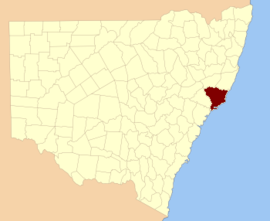
Durham County was one of the original Nineteen Counties in New South Wales and is now one of the 141 Cadastral divisions of New South Wales. It is bordered on the south and west by the Hunter River, and on the north and east by the Williams River. It includes Aberdeen and Muswellbrook. Before 1834, the area known as Durham County included what later became Gloucester and most of Brisbane counties, as far west as the Liverpool Range, and east to the Pacific, including Port Stephens, as shown on an 1832 map.

Northumberland County, New South Wales Cadastral in New South Wales, Australia

Northumberland County was one of the original Nineteen Counties in New South Wales and is now one of the 141 Cadastral divisions of New South Wales. It included the area to the north of Broken Bay, including Lake Macquarie and Newcastle. It was bounded by the part of the Hawkesbury River to the south, the Macdonald River to the south-west, and the Hunter River to the north.

St Vincent County Cadastral in Australian Capital Territory

St Vincent County was one of the original Nineteen Counties in New South Wales and is now one of the 141 Cadastral divisions of New South Wales. It included the south coast area encompassing Batemans Bay, Ulladulla, Jervis Bay and inland to Braidwood. The Shoalhaven River is the boundary to the north and west, and the Deua River the boundary to the south.

Cook County, New South Wales Cadastral in New South Wales, Australia

Cook County was one of the original Nineteen Counties in New South Wales and is now one of the 141 Cadastral divisions of New South Wales. It includes the area to the west of Sydney in the Blue Mountains, between the Colo River in the north, and the Coxs River in the south and west, encompassing Lithgow, Mount Victoria, Katoomba, Wentworth Falls, Lawson and most of the other towns in the Blue Mountains. The Nepean River is the border to the east. Before 1834, the area was part of the Westmoreland, Northumberland and Roxburgh counties.

Brisbane County Cadastral in New South Wales, Australia

Brisbane County was one of the original Nineteen Counties in New South Wales and is now one of the 141 Cadastral divisions of New South Wales. It includes Scone, Merriwa and Murrurundi. The Goulburn River is the boundary to the south and the Hunter River the boundary to the south-east. The Liverpool Range area is the boundary to the north, and the Krui River the boundary to the west.

Phillip County Cadastral in New South Wales, Australia

Phillip County was one of the original Nineteen Counties in New South Wales and is now one of the 141 Cadastral divisions of New South Wales. It includes the area to the east of Mudgee and Gulgong. The Cudgegong River is the border to the south-west, and the Goulburn River the border to the north.

Beresford County Cadastral in New South Wales, Australia

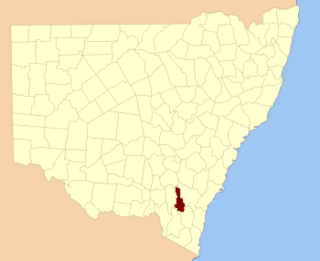
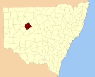
Beresford County is one of the 141 Cadastral divisions of New South Wales. It contains Cooma and Bredbo. Part of the Murrumbidgee River forms the boundary in the north-west, and a separate part of the river forms part of the western boundary.

Cowley County, New South Wales Cadastral in New South Wales, Australia

Cowley County is one of the 141 Cadastral divisions of New South Wales. It contains the locality of Cavan. It was originally bordered on the north, east and part of the south by the Murrumbidgee River, and on the west by the Goodradigbee River. A large part of the county was transferred to the Commonwealth to make the Australian Capital Territory in 1909, with the remaining part the area to the north-west of the ACT as far north as the Burrinjuck Dam, and thin strips of land along the western, southern and south-eastern borders of the ACT.

Barrona County Cadastral in New South Wales, Australia

Barrona County is one of the 141 Cadastral divisions of New South Wales. It is bounded by the Warrego River in the east and the Paroo River in the west.

Ewenmar County Cadastral in New South Wales, Australia

Ewenmar County is one of the 141 Cadastral divisions of New South Wales. It is located between the Macquarie River on the west, and the Castlereagh River on the east. This is the area between Warren and Gilgandra.

Finch County Cadastral in New South Wales, Australia

Finch County is one of the 141 Cadastral divisions of New South Wales. It is bounded by the Narran River in the west, the Barwon River to the south and east, and the Queensland border to the north. It includes Lightning Ridge.

Flinders County Cadastral in New South Wales, Australia

Flinders County is one of the 141 Cadastral divisions of New South Wales. It is located to the south west of the Bogan River.

Irrara County Cadastral in New South Wales, Australia

Irrara County is one of the 141 Cadastral divisions of New South Wales. It is located south of the border with Queensland, east of the Paroo River, and west of the Warrego River.

Kennedy County Cadastral in New South Wales, Australia

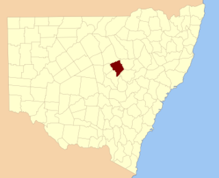
Kennedy County is one of the 141 Cadastral divisions of New South Wales. It is located to the west of the Bogan River in the area around Tottenham and Tullamore.

Narromine County Cadastral in New South Wales, Australia

Narromine County is one of the 141 Cadastral divisions of New South Wales. It is located between the Bogan River on the west and the Macquarie River on the east, in the area around Narromine.

Oxley County Cadastral in New South Wales, Australia

Oxley County, New South Wales is one of the 141 Cadastral divisions of New South Wales. It is located between the Bogan River on the west, and the Macquarie River on the east. This is the area approximately between Warren and Nyngan.

Rankin County, New South Wales Cadastral in New South Wales, Australia

Rankin County is one of the 141 Cadastral divisions of New South Wales. It includes part of the Paroo-Darling National Park. The border to the north-west is the Darling River.

Wangat River, a perennial river of the Hunter River catchment, is located in the Hunter region of New South Wales, Australia.

Wards River, a mostly perennial river of the Mid-Coast Council system, is located in the Mid North Coast and Upper Hunter regions of New South Wales, Australia.

References

  1. "Gloucester (County)". Geographical Names Register (GNR) of NSW. Geographical Names Board of New South Wales . Retrieved 30 December 2007. OOjs UI icon edit-ltr-progressive.svg