
Parramatta is a satellite city of Sydney, Australia's largest city and the capital of New South Wales. It is the primary central business district (CBD) for Greater Western Sydney, located approximately 24 kilometres (15 mi) west of Central Sydney, on the banks of the Parramatta River.

Redfern is an inner southern suburb of Sydney located 3 kilometres (1.9 mi) south of the Sydney central business district and is part of the local government area of the City of Sydney. Strawberry Hills is a locality on the border with Surry Hills. The area experienced the process of gentrification and is subject to extensive redevelopment plans by the state government, to increase the population and reduce the concentration of poverty in the suburb and neighbouring Waterloo.
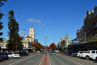
Goulburn is a regional city in the Southern Tablelands of New South Wales, Australia, approximately 195 kilometres (121 mi) south-west of Sydney and 90 kilometres (56 mi) north-east of Canberra. It was proclaimed as Australia's first inland city through letters patent by Queen Victoria in 1863. Goulburn had a population of 24,565 at June 2021. Goulburn is the seat of Goulburn Mulwaree Council.

Richmond is a historic town in north-west of Sydney, New South Wales, Australia. Richmond is in local government area of City of Hawkesbury and comes under Sydney Metropolitan area. It is located 20 metres above sea level on the alluvial Hawkesbury River flats, at the foot of the Blue Mountains. It is about 65 km by road from Sydney, 22 km from Penrith, 26 km from Blacktown, 40 km from Parramatta, 78 km from Lithgow and 5 km from Windsor. Richmond Town is now part of Sydney urban area have all amenities including Shopping Malls, Service NSW, Schools, TAFE, University, Post Office, Restaurants, Railway Station, Cafe, Hotel and Supermarkets.
The Rocks is a suburb, tourist precinct and historic area of Sydney's city centre, in the state of New South Wales, Australia. It is located on the southern shore of Sydney Harbour, immediately north-west of the Sydney central business district.
Randwick is a suburb in the Eastern Suburbs of Sydney, in the state of New South Wales, Australia. Randwick is located 6 kilometres south-east of the Sydney central business district and is the administrative centre for the local government area of the City of Randwick. The postcode is 2031.

Windsor is a historic town in north-west of Sydney, New South Wales, Australia. It is the council seat of the Hawkesbury local government area. The town sits on the Hawkesbury River, enveloped by farmland and Australian bush. Many of the oldest surviving European buildings in Australia are located at Windsor. It is 56 km (35 mi) north-west of the Sydney CBD, on the fringes of urban sprawl.

Wahroonga is a suburb in the Upper North Shore of Sydney, in the state of New South Wales, Australia, 18 kilometres north-west of the Sydney central business district, in the local government areas of Ku-ring-gai Council and Hornsby Shire. North Wahroonga is an adjacent separate suburb of the same postcode.
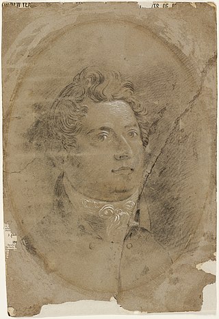
Francis Howard Greenway was an English-born architect who was transported to Australia as a convict for the crime of forgery. In New South Wales he worked for the Governor, Lachlan Macquarie, as Australia's first government architect. He became widely known and admired for his work displayed in buildings such as St Matthew's Church, St James' Church and Hyde Park Barracks.

Burwood is a suburb in the Inner West of Sydney, in the state of New South Wales, Australia. It is 10 kilometres (6.2 mi) west of the Sydney central business district and is the administrative centre for the local government area of Municipality of Burwood.
John Verge (1782–1861) was an English architect, builder, pioneer settler in the Colony of New South Wales, who migrated to Australia and pursued his career there. Verge was one of the earliest and the most important architect of the Greek Revival in Australia. He also brought more comprehensive range of Regency style than any contemporary architects. His design indicates the increasing of sophistication compared to previous architect's design.

Prospect is a suburb of Sydney, in the state of New South Wales, Australia. Prospect is located 32 kilometres west of the Sydney central business district in the local government area of the City of Blacktown and a small part of Cumberland City Council, is part of the Greater Western Sydney region. One of the oldest suburbs in Sydney, Prospect takes its name from the prominent nearby landmark of Prospect Hill - from the top of which people could get a prospect of the surrounding countryside.

Woollahra Municipal Council is a local government area in the eastern suburbs of Sydney, in the state of New South Wales, Australia. Woollahra is bounded by Sydney Harbour in the north, Waverley Council in the east, Randwick City in the south and the City of Sydney in the west.

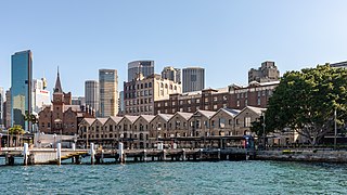
Millers Point is an inner-city suburb of Sydney, in the state of New South Wales, Australia. It is on the north-western edge of the Sydney central business district, adjacent to The Rocks and is part of the local government area of the City of Sydney.

The City of Lithgow is a local government area in the Central West region of New South Wales, Australia. The area is located adjacent to the Great Western Highway and the Main Western railway line.

Colonel Walter Liberty Vernon was an English architect who migrated to Australia and pursued his career as an architect in Sydney, New South Wales. In his role as the New South Wales Government Architect he is noted for designing multiple government buildings, many of which are extant with listings on national and state heritage registers.

Queens Square is a public square in central Sydney, Australia. The square is located at the junction of King Street with Phillip Street and Macquarie Street. It is bounded on the south by St James Road and Prince Albert Road.

Mortimer William Lewis was an English-born architect, surveyor and public servant who migrated to Australia and became Colonial Architect in the colony of New South Wales from 1835 to 1849. Lewis was responsible for designing and overseeing many government buildings in Sydney and rural New South Wales, many of which are heritage listed.
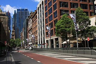
York Street is a street in the Sydney central business district in New South Wales, Australia. York Street runs 1.050 kilometres (0.652 mi) in a north to south direction only and is used predominantly by buses from the northern districts of Sydney.


