Related Research Articles

Gloucestershire is a ceremonial county in South West England. It is bordered by Herefordshire to the north-west, Worcestershire to the north, Warwickshire to the north-east, Oxfordshire to the east, Wiltshire to the south, Bristol and Somerset to the south-west, and the Welsh county of Monmouthshire to the west. The city of Gloucester is the largest settlement and the county town.

Stroud is a market town and civil parish in Gloucestershire, England. It is the main town in Stroud District. The town's population was 13,500 in 2021.

Filton is a town and civil parish in South Gloucestershire, England, 6 miles (10 km) north of Bristol. Along with nearby Patchway and Bradley Stoke, Filton forms part of the Bristol urban area and has become an overflow settlement for the city. Filton Church dates back to the 12th century and is designated a Grade II listed building.

Crouch Hill railway station is a London Overground station on Crouch Hill in the London Borough of Islington, north London. It is on the Gospel Oak to Barking line, 3.8 miles (6.1 km) from St Pancras and is situated between Upper Holloway and Harringay Green Lanes.

Stroud Green is a suburb and electoral ward in north London, England, split between the London boroughs of Haringey and Islington. On its south-western side, Stroud Green Road forms part of the boundary between the two boroughs.
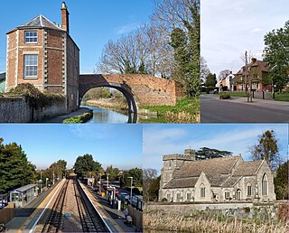
Stonehouse is a town in the Stroud District of Gloucestershire in southwestern England.

Stonehouse railway station serves the town of Stonehouse in Gloucestershire, England. The station is a stop on the Golden Valley Line between Swindon and Gloucester; it is located 104 miles 74 chains (168.9 km) down the line from London Paddington.
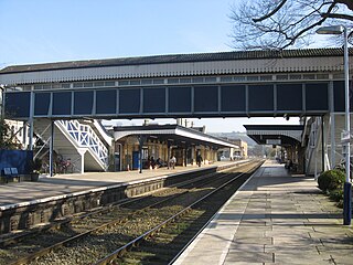
Stroud railway station serves the market town of Stroud in Gloucestershire, England. It is a stop on the Gloucester–Swindon Golden Valley Line and was designed by Isambard Kingdom Brunel. It is located 102 miles 13 chains (164.4 km) west of London Paddington.

Kemp Town railway station was the terminus station of the Kemp Town branch line, a short branch line serving the Kemptown district of Brighton, England.

Stroud Green railway station is a former station in the Stroud Green area of north London. It was located between Finsbury Park station and Crouch End station on a bridge over Stapleton Hall Road. The station had platforms cantilevered from the bridge structure and a wooden station building at ground level under and on either side of the bridge, with a station master's house to the north of it. The bridge still exists and now carries the Parkland Walk cycle and pedestrian path, whilst the station master's house serves as a community centre.
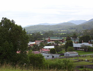
Stroud is a small country town one hour north of Newcastle, New South Wales, Australia. It is part of the Mid-Coast Council local government area. The major road through Stroud is the Bucketts Way. At the 2021 census, Stroud had a population of 988.
The Cheltenham and Great Western Union Railway was a railway company intended to link Cheltenham, Gloucester and Swindon, in England. It was authorised in 1836 but it found it very hard to raise money for the construction, and it opened only a part of its line, between Swindon and Cirencester, in 1841. It sold its business to the Great Western Railway, which quickly built the line through to Gloucester in 1845 and Cheltenham in 1847; part of that route was shared with other companies.

The Great Western Railway road motor services operated from 1903 to 1933 by the Great Western Railway, both as a feeder to their train services, and as a cheaper alternative to building new railways in rural areas. They were the first successful bus services operated by a British railway company.

Stonehouse railway station, also known as Stroudwater station after the nearby canal, was a station in Stonehouse, England, on the Bristol and Gloucester Railway between Haresfield and Frocester.
The Stonehouse and Nailsworth Railway was a short railway line in the county of Gloucestershire, England. It was promoted independently to connect the industrial town of Nailsworth to the main line railway network at Stonehouse. It opened in 1867, but was immediately in financial difficulty, due largely to debenture interest payments and other financial commitments from the construction.

Dudbridge railway station served the Stroud suburb of Dudbridge and the village of Selsley, little more than 1 mile (1.6 km) from Stroud, in Gloucestershire, England. The station was on the 5+3⁄4 miles (9.3 km) long Stonehouse and Nailsworth Railway, later part of the Midland Railway.
Stroud railway station served the town of Stroud, in Gloucestershire, England. The station was on a short 1.25 mi-long branch from Dudbridge on the Stonehouse and Nailsworth Railway, part of the Midland Railway. It was not connected to the earlier and still used Stroud railway station on the Great Western Railway.

Brimscombe Bridge Halt was opened on 1 February 1904 on what is now the Golden Valley Line between Kemble and Stroud. This line was opened in 1845 as the Cheltenham and Great Western Union Railway from Swindon to Gloucester and this was one of many small stations and halts built on this line for the local passenger service. This halt opened following the introduction of the GWR steam railmotor services between Stonehouse and Chalford. The halt was between Brimscombe and Stroud, and featured staggered platforms either side of the overbridge for the local road "Brimscombe Hill", with the down platform on the East side and the up platform on the West. Access to the basic wooden platforms was from the overbridge. Each with GWR pagoda style shelters soon after opening and electric lighting was installed in February 1939 at an estimated cost of £90.

Brightside is an industrial area of Sheffield, South Yorkshire, England lying on a hill north of Attercliffe and the River Don.
Sharpness railway station served the village and docks of Sharpness in Gloucestershire, England from 1875 to 1964.
References
- ↑ "Stroud Road Station". NSWrail.net. Retrieved 6 March 2013.
| | This article about a railway station in New South Wales is a stub. You can help Wikipedia by expanding it. |