
Gladesville Bridge is a heritage-listed concrete arch road bridge that carries Victoria Road over the Parramatta River, linking the Sydney suburbs of Huntleys Point and Drummoyne, in the local government areas of Canada Bay and Hunter's Hill, in New South Wales, Australia. Despite its name, the bridge is not in Gladesville.

Myall Lakes, a series of fresh water lakes protected under the Ramsar Convention, are located within the Mid-Coast Council local government area in the Mid North Coast region of New South Wales, Australia.
Tea Gardens is a locality in the Mid-Coast Council local government area, in Mid North Coast region of New South Wales, Australia.

Hawks Nest is a small town of the Mid-Coast Council local government area in the Hunter and Mid North Coast regions of New South Wales, Australia, located north of Port Stephens between the Tasman Sea and the Myall River. It was named after a large hawk's nest in a tree on the Myall River that was used as a navigational aid. The traditional custodians of this land are the Worimi people.

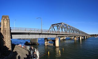
The Iron Cove Bridge is a heritage-listed road bridge that carries Victoria Road (A40) across Iron Cove, between the Sydney suburbs of Drummoyne and Rozelle. Iron Cove is an arm of Sydney Harbour.

The Captain Cook Bridge is a road bridge that carries Taren Point and Rocky Point Roads across the Georges River in southern Sydney, in the state of New South Wales, Australia. The precast prestressed concrete girder bridge crosses near the river mouth as it empties into Botany Bay; and links the St George and Sutherland areas of Sydney. The bridge comprises a dual carriageway with three lanes in each direction of highway grade-separated conditions; and pedestrian and bicycle traffic, via two grade-separated paths. on the eastern and western sides of the bridge.
Tom Uglys Bridge are two road bridges, completed in 1929 and 1987, that carry the Princes Highway across the Georges River in southern Sydney, in the state of New South Wales, Australia. The bridges link the St George area at Blakehurst to the Sutherland Shire at Sylvania. Tom Uglys Bridge is one of six major road crossings of Georges River.

The Victoria Bridge, also known as the Victoria Bridge over the Nepean River, is a heritage-listed former railway bridge and now wrought iron box plate girder road bridge across the Nepean River on the Great Western Highway in the western Sydney suburb of Penrith in the City of Penrith local government area of New South Wales, Australia. The bridge was designed by John Whitton, the Engineer–in–Chief of New South Wales Government Railways, and built from 1862 to 1867 by William Piper, Peto Brassey and Betts (superstructure), William Watkins (piers). It is also known as Victoria Bridge, The Nepean Bridge and RTA Bridge No. 333. It was added to the New South Wales State Heritage Register on 27 May 2016.

Myall River, an open semi-mature brackish freshwater barrier estuary of the Mid-Coast Council system, is located in the Mid North Coast region of New South Wales, Australia.

The Roseville Bridge, is a pre-stressed concrete box girder road bridge that carries Warringah Road, part of the A38 across Middle Harbour, located adjacent to the suburb of Roseville, in Sydney, New South Wales, Australia. The bridge is one of two crossings of Middle Harbour, the other being the Spit Bridge.

The Mooney Mooney Bridge, officially the Mooney Mooney Creek Bridge, and popularly known as The NSW Big Dipper Bridge, is a twin cantilever bridge that carries the Pacific Motorway (M1) across Mooney Mooney Creek, located near Mooney Mooney in the Brisbane Water National Park on the Central Coast of New South Wales, Australia. The concrete box girder bridge was opened on 14 December 1986 by the Prime Minister of Australia, Bob Hawke, and is owned and maintained by Transport for NSW, an agency of the Government of New South Wales.

The Harwood Bridge is a two-lane steel truss bridge which carried the Pacific Highway over the Clarence River in the Northern Rivers region of New South Wales, Australia from 1966 until 2019, when it was replaced by a four-lane 1.5-kilometre-long (4,921 ft) concrete bridge, located 20 metres (66 ft) to its east. The Harwood Bridge has been retained to provide access to Harwood Island.
The Dennis Bridge is a steel truss road bridge that carries Hastings River Drive across the Hastings River, near Port Macquarie, New South Wales, Australia. The bridge carried the Pacific Highway from December 1961 until November 2017, when it was replaced by the (new) Hastings River Bridge, a concrete road bridge. The Dennis Bridge is managed by the Port Macquarie-Hastings Council.

The Peats Ferry Bridge is a steel truss bridge that carries the Pacific Highway (B83) across the Hawkesbury River, between Kangaroo Point and Mooney Mooney Point, located 40 kilometres (25 mi) north of Sydney in New South Wales, Australia. The bridge carries the Hornsby to Kariong section of highway, while the adjacent Brooklyn Bridge carries the Pacific Motorway (M1).
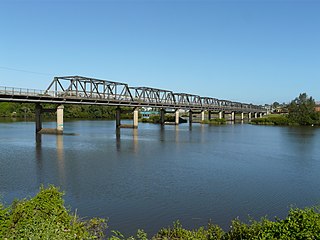
The Martin Bridge is a road bridge that carries the Manning River Drive across the Manning River in Taree, in the Mid North Coast region of New South Wales, Australia. In 2010, the bridge was added to New South Wales State Heritage Register.
The Brooklyn Bridge is a local nickname for the Hawkesbury River Road Bridge, a concrete girder bridge that carries the Pacific Motorway (M1) across the Hawkesbury River between Kangaroo Point and Mooney Mooney Point, located 35 kilometres (22 mi) north of Sydney in New South Wales, Australia. The bridge comprises a dual carriageway with three lanes in each direction of motorway grade-separated conditions.

The Macquarie River railway bridge is a heritage-listed disused railway bridge across the Macquarie River that was previously located on the Main Western line in Bathurst in the Bathurst Region local government area of New South Wales, Australia. It was built in 1876. It is also known as Bathurst Rail Bridge over Macquarie River and Bathurst – Kelso Railway Bridge. The property is owned by Transport Asset Holding Entity, an agency of the Government of New South Wales. The bridge was added to the New South Wales State Heritage Register on 2 April 1999 and was added to the Register of the National Estate on 18 April 1989.

The Yowaka River bridge is a heritage-listed road bridge that carries the Princes Highway across the Yowaka River at Greigs Flat, New South Wales, Australia. It was built in 1936. The bridge is also known as the Yowaka Bridge near Eden. The bridge is owned by Transport for NSW. It was added to the New South Wales State Heritage Register on 20 June 2000.

The Cooks River Sewage Aqueduct is a heritage-listed sewage aqueduct located at Pine Street, Earlwood, New South Wales, Australia. It crosses the Cooks River to Thornley Street, Marrickville. It was designed by Sewerage Construction Branch and NSW Department of Public Works and built during 1895 by J. F. Carson, contractor. The property is owned by Sydney Water, an agency of the Government of New South Wales. It was added to the New South Wales State Heritage Register on 18 November 1999.

The Hay Bridge is a road bridge that carries the Cobb Highway across the Murrumbidgee River at Hay, New South Wales, Australia. The current bridge is the second bridge located in Hay that crosses the Murrumbidgee; the first bridge was in operation from 1873 until 1973; the second and current bridge has operated since 1973.

