
Pacific Highway is a 790-kilometre-long (491 mi) national highway and major transport route along the central east coast of Australia, with the majority of it being part of Australia's Highway 1. The highway and its adjoining Pacific Motorway between Brisbane and Brunswick Heads and Pacific Motorway between Sydney and Newcastle links the state capitals of Sydney in New South Wales with Brisbane in Queensland, approximately paralleling the Tasman Sea and the Coral Sea of the South Pacific Ocean coast, via regional cities and towns like Gosford, Newcastle, Taree, Port Macquarie, Kempsey, Coffs Harbour, Grafton, Ballina, Byron Bay, Tweed Heads and the Gold Coast, which is part of Queensland. Additionally, between Brunswick Heads and Port Macquarie, the road is also signed as Pacific Motorway, but has not been legally gazetted as such.

Hexham is a suburb of the city of Newcastle, about 15 km (9 mi) inland from the Newcastle CBD in New South Wales, Australia on the bank of the Hunter River.

The Ryde Bridge, also called the Uhrs Point Bridge, are two road bridges that carry Concord Road, part of the A3, across Parramatta River from Ryde in the northern suburbs of Sydney to Rhodes in Sydney's inner west, in New South Wales, Australia.

M1 Pacific Motorway is a 127-kilometre motorway linking Sydney to Newcastle via the Central Coast and Hunter regions of New South Wales. Formerly known but still commonly referred to by both the public and the government as the F3 Freeway, Sydney–Newcastle Freeway, and Sydney–Newcastle Expressway, it is part of the AusLink road corridor between Sydney and Brisbane.
Tom Uglys Bridge are two road bridges, completed in 1929 and 1987, that carry the Princes Highway across the Georges River in southern Sydney, in the state of New South Wales, Australia. The bridges link the St George area at Blakehurst to the Sutherland Shire at Sylvania. Tom Uglys Bridge is one of six major road crossings of Georges River.

The Mooney Mooney Bridge, officially the Mooney Mooney Creek Bridge, and popularly known as The NSW Big Dipper Bridge, is a twin cantilever bridge that carries the Pacific Motorway (M1) across Mooney Mooney Creek, located near Mooney Mooney in the Brisbane Water National Park on the Central Coast of New South Wales, Australia. The concrete box girder bridge was opened on 14 December 1986 by the Prime Minister of Australia, Bob Hawke, and is owned and maintained by Transport for NSW, an agency of the Government of New South Wales.

The Ellsworth Street Bridge is a highway bridge that crosses the Willamette River in Albany, Oregon, United States. Built in 1925, the two-lane structure carries U.S. Route 20 eastbound traffic, with the adjacent Lyon Street Bridge carrying westbound traffic. The 1,090-foot-long (330 m) steel truss bridge was designed by Conde McCullough and opened in 1926.
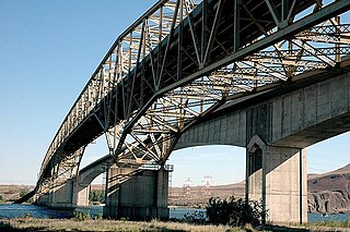
The Umatilla Bridge is the collective name for a pair of bridges in the northwest United States, carrying Interstate 82/U.S. Route 395 (I-82/US 395) across the Columbia River at the Washington–Oregon border. The older bridge opened in July 1955 and is a steel through truss cantilever bridge and carries southbound traffic. Northbound traffic and pedestrians travel on the newer concrete arch bridge, opened in 1988.

The Kettle Falls Bridges is the collective name for a pair of steel cantilever bridges carrying State Route 20/U.S. Route 395 and the Kettle Falls International Railway across the Columbia River at Kettle Falls, Washington. The south bridge carries motor vehicle traffic while the similar northern span is used for rail.

The Harwood Bridge is a two-lane steel truss bridge which carried the Pacific Highway over the Clarence River in the Northern Rivers region of New South Wales, Australia from 1966 until 2019, when it was replaced by a four-lane 1.5-kilometre-long (4,921 ft) concrete bridge, located 20 metres (66 ft) to its east. The Harwood Bridge has been retained to provide access to Harwood Island.
The Dennis Bridge is a steel truss road bridge that carries Hastings River Drive across the Hastings River, near Port Macquarie, New South Wales, Australia. The bridge carried the Pacific Highway from December 1961 until November 2017, when it was replaced by the (new) Hastings River Bridge, a concrete road bridge. The Dennis Bridge is managed by the Port Macquarie-Hastings Council.

The Peats Ferry Bridge is a steel truss bridge that carries the Pacific Highway (B83) across the Hawkesbury River, between Kangaroo Point and Mooney Mooney Point, located 40 kilometres (25 mi) north of Sydney in New South Wales, Australia. The bridge carries the Hornsby to Kariong section of highway, while the adjacent Brooklyn Bridge carries the Pacific Motorway (M1).
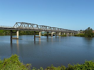
The Martin Bridge is a road bridge that carries the Manning River Drive across the Manning River in Taree, in the Mid North Coast region of New South Wales, Australia. In 2010, the bridge was added to New South Wales State Heritage Register.

The Rio Vista Bridge is a continuous truss span with a vertical-lift bridge in the middle which carries California State Route 12 across the Sacramento River at Rio Vista, California. The present bridge was completed in 1960 and is one of several moveable bridges spanning rivers in the Sacramento–San Joaquin River Delta. It is named after Helen Madere, who served as vice-mayor of Rio Vista. As of 2013 the bridge carries approximately 21,000 cars per day.

Morpeth Bridge is a heritage-listed road bridge over the Hunter River at Morpeth, New South Wales, Australia. It was designed by Percy Allan and built from 1896 to 1898 by Samuel McGill. It is also known as Morpeth Bridge over the Hunter River. The property is owned by Transport for NSW.
The Brooklyn Bridge is a local nickname for the Hawkesbury River Road Bridge, a concrete girder bridge that carries the Pacific Motorway (M1) across the Hawkesbury River between Kangaroo Point and Mooney Mooney Point, located 35 kilometres (22 mi) north of Sydney in New South Wales, Australia. The bridge comprises a dual carriageway with three lanes in each direction of motorway grade-separated conditions.

The Red Rock Bridge was a bridge across the Colorado River at Topock, Arizona that carried the Atlantic & Pacific Railroad. It was built in 1890, replacing a wooden bridge dating to 1883 that was repeatedly washed out during spring flooding. It was used by the railroad until 1945 when a new bridge was built. The Red Rock Bridge was then converted to carry the automobile traffic of U.S. Route 66, and did so from 1947 until 1966 when Route 66 traffic was directed onto the Interstate 40 bridge. At that time the Red Rock Bridge was abandoned, and it was eventually dismantled in 1976.
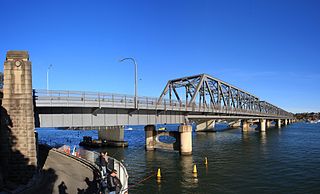
The Tourle Street Bridge is a pair of road bridges that carry Tourle Street across the Hunter River from Mayfield West to Kooragang in the Hunter Region of New South Wales, Australia.
The Fitzgerald Bridge is a bridge that carries the New England Highway over the Hunter River to the north of Aberdeen, New South Wales, Australia.

