Wombeyan Caves Road

Last updated

Wombeyan Caves Road

Wombeyan Caves Rd typical unsealed.JPG
A typical unsealed section of Wombeyan Caves Road, showing sandstone outcrops and lack of guardrails
Australia New South Wales location map blank.svg
Red pog.svg
East end
Red pog.svg
West end
Coordinates
General information
TypeRural road
Length84 km (52 mi) [1]
Gazetted August 1928 [2]
Tourist routesAustralian Tourist Drive 13.svg Tourist Route 13
(Richlands-Wombeyan Caves)
Major junctions
East end Old Hume Highway
Woodlands, New South Wales
West endAustralian Tourist Drive 13.svg Taralga Road
Richlands, New South Wales
Location(s)
Major settlements High Range, Bullio, Wombeyan Caves

Wombeyan Caves Road is a New South Wales country road linking Mittagong near Hume Highway in the east to Goulburn-Oberon Road at the locality of Richlands in the west.

Contents

Route

At its eastern end, the road starts at Old Hume Highway just west of Mittagong. Access from the north of Mittagong is via Mittagong, while access from the south is via the half interchange at the southern end of the Mittagong Bypass section of Hume Highway. It passes through farmland and the locality of High Range as a sealed road. Further west, it changes to unsealed and continues through farmland before entering the Wombeyan Caves area. The road conditions deteriorate substantially as the road goes further west until it reaches the main Wombeyan Caves reserve camping area. West of the camping area, the road is sealed as it climbs a tight, winding section up the mountain side. At the top of that hill, the road reverts to unsealed but is wider and straighter. Close to its western end, the road is a reasonable standard sealed road. This road has no major intersections.

Wombeyan Caves Road goes through the following settlements, from east to west: Mittagong, High Range, Wombeyan Caves and Richlands.

History

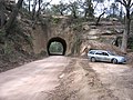
The road passes through a historical single lane tunnel carved through the sandstone ridge in a forest area part way through the farmland section. The tunnel is around 22 m long at ground level, but has a sandstone outcrop extending several metres further at its western end. In August 1899 the local newspaper, Goulburn Evening Penny Post, described the progress of "work of tunnelling through the sandstone ridge at the gullies near Bullio is being rapidly pushed on by a gang of experienced men, who are using ratchet drills and other improved appliances, so that this portion of the work will be completed in about six weeks". [3] In late January 1900 the new road was opened, J. H. Young (ex-Minister of Works) proposed that "[it] should be named the Duprez-road in honor of a worthy citizen-who had worked hard to secure it-Mr. A. P. Duprez, of Bowral". [4]

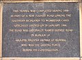
A plaque at the eastern end of the tunnel states:

"This tunnel was completed during 1899 as part of a new tourist road linking the southern highlands to Wombeyan Caves. Officially opened on 29 January 1900, the road was originally named Duprez Road in honour of Adolphe Prosper Duprez of Bowral who was the driving force behind its construction."

The passing of the Main Roads Act of 1924 [5] through the Parliament of New South Wales provided for the declaration of Main Roads, roads partially funded by the State government through the Main Roads Board (later the Department of Main Roads, and eventually Transport for NSW). Main Road No. 258 was declared along this road on 8 August 1928, from the intersection with Hume Highway (today Old Hume Highway) near Woodlands via Wombeyan Caves to Oberon-Taralga Road (today Taralga Road) to Richlands; [2] with the passing of the Main Roads (Amendment) Act of 1929 [6] to provide for additional declarations of State Highways and Trunk Roads, this was amended to Main Road 258 on 8 April 1929.

The Department of Main Roads, which had succeeded the MRB in 1932, extended the eastern end of Main Road 258 along Old Hume Highway to the intersection with Bowral Road in Mittagong, on 2 October 1992. [7]

The passing of the Roads Act of 1993 [8] updated road classifications and the way they could be declared within New South Wales. Under this act, Wombeyan Caves Road today retains its declaration as part of Main Road 258. [9]

The road is allocated Tourist Route 13, from its western end at Richlands to the turn-off to Wombeyan Caves.

Road conditions

Due to the extremely poor condition of the road for several kilometres east of the Wombeyan Caves camping area, it is strongly recommended to access the caves reserve from Goulburn-Oberon Road. Regardless of the impression that might be given by road maps, the road should not be considered to be a through road unless you are in a 4WD or have a lot of time. Hume Highway and Goulburn-Oberon Road via Goulburn are a better option if you are not aiming to get to somewhere between the Wombeyan Caves camping area and the sandstone tunnel west of High Range. However, if one takes their time, a normal family car can do the trip but care must be taken on bends.

Please check on the status of the road before driving it as the portion down to and up from the Wollondilly River can often become extremely rutted and washed out, blocked by large fallen boulders or eroded so badly it becomes unpassable and is closed. On 30 January 2015 the local council had closed the road to all traffic between Goodmans Ford (where the road crosses the Wollondilly River) and Langs Road due to significant parts of the road having been washed away down the cliff.

As of 13 November 2015, Wombeyan Caves Road has reopened after months of repairs to the damaged section of road approximately 11 kilometers west of the Goodman's Ford crossing. [10] However motorists should still exercise caution as the road is largely unsealed and some sections are still very rough.

Major intersections

LGALocationkm [1] miDestinationsNotes
Wingecarribee Woodlands 0.00.0 Old Hume Highway   Mittagong, Bowral Eastern terminus of road
High Range 7.44.6Greenhills Road  Berrima
Wollondilly River 45.428.2Goodman's Ford Bridge
Upper Lachlan Wombeyan Caves 61.738.3Victoria Arch Drive  Wombeyan Caves Entrance to Wombeyan Karst Conservation Reserve
Eastern terminus of Tourist Drive 13
Richlands 84.052.2Australian Tourist Drive 13.svg Taralga Road (Tourist Route 13 south, unallocated north)  Goulburn, Taralga, Oberon Western terminus of road
Tourist Route 13 continues south along Taralga Road
1.000 mi = 1.609 km; 1.000 km = 0.621 mi
  •        Route transition

See also

Related Research Articles

<span class="mw-page-title-main">Nattai National Park</span> Protected area in New South Wales, Australia

The Nattai National Park is a protected national park that is located in the Macarthur and Southern Highlands regions of New South Wales, in eastern Australia. 48,984-hectare (121,040-acre) It is situated approximately 150 kilometres (93 mi) southwest of the Sydney central business district and primarily encompasses the valley of the Nattai River, which is surrounded by spectacular sandstone cliffs. Part of the Southern Highlands Shale Forest and Woodland, the park is covered in dry sclerophyll forest – mostly eucalypt and has fairly frequent forest fires. It is largely an untouched wilderness area and receives very few visitors, as it has virtually no facilities and is fairly remote, despite its proximity to Sydney.

<span class="mw-page-title-main">Hume Highway</span> Major national highway in Australia

Hume Highway, inclusive of the sections now known as Hume Freeway and Hume Motorway, is one of Australia's major inter-city national highways, running for 840 kilometres (520 mi) between Melbourne in the southwest and Sydney in the northeast. Upgrading of the route from Sydney's outskirts to Melbourne's outskirts to dual carriageway was completed on 7 August 2013.

<span class="mw-page-title-main">Federal Highway (Australia)</span> Highway in New South Wales and the Australian Capital Territory

Federal Highway is a highway in New South Wales and the Australian Capital Territory. It is a part of a motorway-standard link between Sydney and Canberra, and is also the main thoroughfare between those cities.

<span class="mw-page-title-main">Upper Lachlan Shire</span> Local government area in New South Wales, Australia

Upper Lachlan Shire is a local government area in the Southern Tablelands region of New South Wales, Australia. The Shire was formed in February 2004 from Crookwell Shire and parts of Mulwaree, Gunning and Yass Shires.

Illawarra Highway is a short state highway in New South Wales, Australia. It connects Wollongong to the Southern Highlands and links Princes Highway and Hume Highway. It is named after the geographical area it crosses, the Illawarra region.

<span class="mw-page-title-main">Taralga</span> Town in New South Wales, Australia

Taralga is the traditional land of the Gundungurra people. Today it is a small village in the Southern Tablelands of New South Wales, Australia, in Upper Lachlan Shire. It is located at the intersection of the Goulburn-Oberon Road and the Laggan-Taralga Road. It is accessible from Oberon to the north, Mittagong to the east, Goulburn to the south, and Crookwell to the west. At the 2016 census, Taralga had a population of 467. Taralga is located relatively close to the famous Wombeyan Caves. The town experiences a volatile climate and is sometimes affected by snow in the winter months.

<span class="mw-page-title-main">Wombeyan Caves</span> Protected area in New South Wales, Australia

The Wombeyan Caves are caves that have formed in marble, in the Wombeyan Karst Conservation Reserve, New South Wales, Australia. Wombeyan Caves is a tourist attraction and local holiday area, as well as a reserve for endangered species, such as several species of wallaby, bird, possum, and wombat.

<span class="mw-page-title-main">Mittagong</span> Town in New South Wales, Australia

Mittagong is a town located in the Southern Highlands of New South Wales, Australia, in Wingecarribee Shire. The town acts as the gateway to the Southern Highlands when coming from Sydney. Mittagong is situated at an elevation of 635 metres (2,083 ft). The town is close to Bowral, Berrima, Moss Vale and the Northern Villages such as Yerrinbool and Colo Vale. Moreover, Mittagong is home to many wineries of the Southern Highlands which has been a recent growing wine and cellar door region.

<span class="mw-page-title-main">Southern Highlands Line</span>

The Southern Highlands Line is an Intercity rail service operated by NSW TrainLink that services the Macarthur, Southern Highlands and Southern Tablelands regions of New South Wales. First operating in 1869, the service runs from Campbelltown across the Main Southern railway line through to Goulburn, with peak hour services extending the route to Central. The railway service operates alongside a bus route from Picton to Bowral, operating on the route of the Picton – Mittagong loop railway line, and a regional coach service from Bundanoon to Wollongong on the South Coast Line, operating on the corridor of the Unanderra–Moss Vale railway line.

High Range is a locality located in the Southern Highlands of New South Wales, Australia near Bowral and Mittagong. The village is centred just off the Wombeyan Caves Road 55 kilometres (34 mi) east of the Wombeyan Caves. High Range has a church, a rural fire station, a bus stop and a cricket pitch.

<span class="mw-page-title-main">Mount Gibraltar</span>

Mount Gibraltar is a mountain with an elevation of 863 metres (2,831 ft) AHD  that is located in the Southern Highlands region, between Bowral and Mittagong, in New South Wales, Australia. Further west is Berrima.

<span class="mw-page-title-main">Bylong Valley Way</span> Road in New South Wales, Australia

Bylong Valley Way is a New South Wales regional road linking Golden Highway near Sandy Hollow to Castlereagh Highway near Ilford. It is named after the Bylong Valley, through which the road passes.

Bathurst-Ilford Road is a 72.0-kilometre (44.7 mi) New South Wales country road linking Ilford to the regional hub of Bathurst.

O'Connell Road is a New South Wales rural road linking Oberon to the regional highway hub of Bathurst, where several roads including Great Western Highway, Mid-Western Highway, Mitchell Highway and Bathurst-Ilford Road join.

<span class="mw-page-title-main">Goulburn-Oberon Road</span>

Goulburn-Oberon Road is a New South Wales country road linking Goulburn near Hume Highway to Oberon. This name is not widely known to most drivers, as the entire allocation is still best known as by the names of its constituent parts: Taralga Road and Abercrombie Road.

The Parish of Mittagong is a parish of the County of Camden in the Southern Highlands region of New South Wales. It includes the town of Bowral and the southern parts of Mittagong.

Camden Valley Way is a 23-kilometre (14 mi) arterial road between the southwestern fringes of suburban Sydney and the historic town of Camden. It is a former alignment of Hume Highway.

<i>Taralga Echo</i>

The Taralga Echo was a weekly English-language newspaper published in Crookwell, New South Wales from 1924 to 1927.

<span class="mw-page-title-main">Richlands, New South Wales</span> Town in New South Wales, Australia

Richlands is a locality in the Upper Lachlan Shire, New South Wales, Australia. It lies about 5 km north of Taralga and about 95 km south of Oberon on the road from Goulburn to Oberon and Bathurst. At the 2016 census, it had a population of 34. It had a school from June 1868 to August 1879, which was designated as a "provisional school" for eight months and then as a "half-time" school. It also had a school from 1884 to 1915 and from 1918 to 1953, classified most commonly as a "provisional school", but for periods as a "house to house", "half-time" or "public" school. It was called Abercrombie school until 1894.

<span class="mw-page-title-main">Jenolan Caves Road</span>

Jenolan Caves Road is a rural road in New South Wales, Australia, linking Great Western Highway at Hartley to Edith Road at Jenolan.

References

  1. 1 2 Google (25 August 2022). "Wombeyan Caves Road" (Map). Google Maps . Google. Retrieved 25 August 2022.
  2. 1 2 "Main Roads Act, 1924-1927". Government Gazette of the State of New South Wales. No. 110. National Library of Australia. 17 August 1928. pp. 3814–20. Archived from the original on 3 August 2022. Retrieved 1 August 2022.
  3. "The Wombeyan Caves-Road". Goulburn Evening Penny Post. NSW. 26 August 1899. p. 4. Retrieved 26 February 2013 via National Library of Australia.
  4. "The Wombeyan Caves Road". Australian Town and Country Journal . 10 February 1900. pp. 38–39, 41. Retrieved 26 February 2013 via National Library of Australia.
  5. State of New South Wales, An Act to provide for the better construction, maintenance, and financing of main roads; to provide for developmental roads; to constitute a Main Roads Board Archived 11 August 2022 at the Wayback Machine 10 November 1924
  6. State of New South Wales, An Act to amend the Main Roads Act, 1924-1927; to confer certain further powers upon the Main Roads Board; to amend the Local Government Act, 1919, and certain other Acts; to validate certain payments and other matters; and for purposes connected therewith. Archived 12 August 2022 at the Wayback Machine 8 April 1929
  7. "State Roads Act". Government Gazette of the State of New South Wales. No. 121. National Library of Australia. 2 October 1992. p. 7278. Archived from the original on 19 June 2023. Retrieved 19 June 2023.
  8. State of New South Wales, An Act to make provision with respect to the roads of New South Wales; to repeal the State Roads Act 1986, the Crown and Other Roads Act 1990 and certain other enactments; and for other purposes. Archived 11 August 2022 at the Wayback Machine 10 November 1924
  9. Transport for NSW (August 2022). "Schedule of Classified Roads and Unclassified Regional Roads" (PDF). Government of New South Wales. Retrieved 1 August 2022.
  10. "Wombeyan Caves Road reopens | Wingecarribee Shire Council Media Centre".