Jenolan Caves Road

Last updated

Jenolan Caves Road

Jenolan Caves Road - panoramio - Maksym Kozlenko.jpg
Jenolan Caves Road, Hartley
Australia New South Wales location map blank.svg
Red pog.svg
Northeast end
Red pog.svg
Southwest end
Coordinates
General information
TypeRural road
Length49.7 km (31 mi) [1]
Gazetted August 1928 [2]
Maintained by Transport for NSW
Tourist routesAustralian Tourist Drive 1.svg Tourist Route 1
Major junctions
Northeast endAUS Alphanumeric Route A32.svg Great Western Highway
Hartley, New South Wales
  Duckmaloi Road
Southwest endEdith Road
Jenolan, New South Wales
Location(s)
Major settlements Lowther, Hampton, Jenolan

Jenolan Caves Road is a rural road in New South Wales, Australia, linking Great Western Highway at Hartley to Edith Road at Jenolan.

Contents

The road is a part of Tourist Drive 1 linking the Blue Mountains to Bathurst via Oberon and Hampton.

Route

The road starts at the intersection of the Great Western Highway and Blackmans Creek Road, then travels south and crosses the Coxs River (Glenroy Bridge). From there it travels southwest and ascends Mount Blaxland, then continues to Hampton and to the Duckmaloi Road intersection. Next it winds south to the 5-Mile section which descends to the Grand Arch. It then goes through Jenolan Caves and leads to a parking lot at Jenolan Caves House. From there it continues northwest on the 2-Mile section before turning into Edith Road at the Kanangra Walls Road intersection.

The road is fully sealed across its entire length. The road is as narrow as one lane on the 5-Mile, Grand Arch, and 2-Mile sections, but the majority of the road is two lanes wide.

History

The passing of the Main Roads Act of 1924 [3] through the Parliament of New South Wales provided for the declaration of Main Roads, roads partially funded by the State government through the Main Roads Board (later the Department of Main Roads, and eventually Transport for NSW). Main Road No. 253 was declared along this road on 8 August 1928, from the intersection with Great Western Highway at Hartley) via Hampton to Jenolan Caves (and continuing northwest to Oberon); [2] with the passing of the Main Roads (Amendment) Act of 1929 [4] to provide for additional declarations of State Highways and Trunk Roads, this was amended to Main Road 253 on 8 April 1929.

The passing of the Roads Act of 1993 [5] updated road classifications and the way they could be declared within New South Wales. Under this act, Jenolan Caves Road today retains its declaration as part of Main Road 253, from Hartley to Jenolan Caves (and continuing northwest via Oberon to Bathurst). [6]

Closures

The road has been closed several times over the years due to bushfires and landslips. Two notable closures were the section between Hampton and Jenolan Caves between January and June 2020 due to bushfire damage and landslips from heavy rain and floods, and closure of the same section in March 2021 due to landslips and parts of the road washed away due to heavy rain and flooding. [7] On May 25, 2021, the road was reopened at Hampton with Stop / Slow restrictions. The 5-Mile section was still closed. The 2-Mile section was reopened on May 10, 2021.

Major intersections

LGALocationkm [1] miDestinationsNotes
Lithgow Hartley 0.00.0AUS Alphanumeric Route A32.svg Great Western Highway (A32)  Lithgow, Mount Victoria Northern terminus of road and Tourist Route 1
Coxs River 2.11.3Glenroy Bridge
Lithgow Hartley 6.23.9McKanes Falls Road  Lithgow
Lowther 12.27.6Lowther Siding Road  Little Hartley
Hampton 19.412.1Hampton Road  Rydal
Hampton 23.714.7 Duckmaloi Road   Oberon
Oberon Jenolan 49.730.9Kanangra Walls Road – Kanangra-Boyd National Park
Australian Tourist Drive 1.svg Edith Road (Tourist Route 1)  Oberon, Bathurst Southwestern terminus of road, Tourist Route 1 continues northwest along Edith Road
1.000 mi = 1.609 km; 1.000 km = 0.621 mi
  •        Route transition

See also

Related Research Articles

<span class="mw-page-title-main">Oxley Highway</span> Highway in New South Wales, Australia

Oxley Highway is a rural highway in New South Wales, Australia, linking Nevertire, Gilgandra, Coonabarabran, Tamworth, and Walcha to Port Macquarie, on the coast of the Tasman Sea. It was named to commemorate John Oxley, the first European to explore much of inland New South Wales in 1818.

<span class="mw-page-title-main">Gwydir Highway</span>

Gwydir Highway is a 568-kilometre (353 mi) state highway in northern New South Wales, Australia. The highway was named after the Gwydir River, which in turn was named after a locale in Wales.

<span class="mw-page-title-main">New England Highway</span> Highway in New South Wales and Queensland

New England Highway is an 883-kilometre (549 mi) long highway in Australia running from Yarraman, north of Toowoomba, Queensland at its northern end to Hexham at Newcastle, New South Wales at its southern end. It is part of Australia's National Highway system, and forms part of the inland route between Brisbane and Sydney.

<span class="mw-page-title-main">Bruxner Highway</span>

Bruxner Highway, and its former western alignment as Bruxner Way, are a 420-kilometre (260 mi) state highway and rural road respectively, located in New South Wales, Australia. The route forms an east–west link across the Northern Tablelands in northern New South Wales, close to the border with Queensland, to the Northern Rivers coast. It was named after Michael Bruxner, NSW Minister for Transport from 1932 to 1941.

<span class="mw-page-title-main">Cobb Highway</span>

Cobb Highway is a state highway in the western Riverina and the far western regions of New South Wales, with a short section in Victoria, Australia, designated part of route B75.
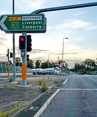
<span class="mw-page-title-main">Olympic Highway</span> Highway in New South Wales

Olympic Highway is a 317-kilometre (197 mi) rural road in the central western and south-eastern Riverina regions of New South Wales, Australia. It services rural communities, links Hume Highway with Mid-Western Highway, and provides part of an alternate road link between Sydney and Albury via Bathurst and Cowra as well as servicing Wagga Wagga, linking with Sturt Highway.

<span class="mw-page-title-main">Kidman Way</span> Highway in New South Wales

Kidman Way is a state rural road in the western Riverina and western region of New South Wales, Australia. The 643-kilometre (400 mi) highway services the Murrumbidgee Irrigation Area and outback communities and links the Newell Highway with the Sturt, Mid-Western, Barrier, Mitchell and Kamilaroi highways. The road is designated route B87 for its entire length, with its northern terminus at Bourke and its southern terminus just north of Jerilderie. Kidman Way is fully sealed and is accessible by two or four-wheel drive.

<span class="mw-page-title-main">Bucketts Way</span> Road in New South Wales, Australia

(The) Bucketts Way is a 151-kilometre (94 mi) rural road that links Gloucester to Taree and Raymond Terrace, in New South Wales, Australia. A former alignment of Pacific Highway, it was later named after the Bucketts Mountains, a prominent mountain range near Gloucester. The entire route is designated as Tourist Route 2.

<span class="mw-page-title-main">Thunderbolts Way</span> Road in New South Wales, Australia

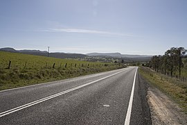
Thunderbolts Way is a 305-kilometre (190 mi) country road located in the Northern Tablelands region of New South Wales, Australia, linking Inverell via Bundarra, Uralla and Walcha to Gloucester The road is partially sealed and passes through thickly forested mountain areas with many nearby national parks and nature reserves.

<span class="mw-page-title-main">Appin Road</span> Road in New South Wales, Australia

Appin Road is a New South Wales secondary highway linking Campbelltown and Sydney's western suburbs with Wollongong. It is named after Appin, which lies on its path.

Central Coast Highway is a 50-kilometre (31 mi) highway through the Central Coast region of New South Wales, Australia. It connects Pacific Motorway (M1) at Kariong with Pacific Highway (A43) at Doyalson. The highway was named after the region it goes through, to provide an easily identifiable route for visitors to the region, and is designated route A49.

Bathurst-Ilford Road is a 72.0-kilometre (44.7 mi) New South Wales country road linking Ilford to the regional hub of Bathurst.

O'Connell Road is a New South Wales rural road linking Oberon to the regional highway hub of Bathurst, where several roads including Great Western Highway, Mid-Western Highway, Mitchell Highway and Bathurst-Ilford Road join.

<span class="mw-page-title-main">Goulburn-Oberon Road</span>

Goulburn-Oberon Road is a New South Wales country road linking Goulburn near Hume Highway to Oberon. This name is not widely known to most drivers, as the entire allocation is still best known as by the names of its constituent parts: Taralga Road and Abercrombie Road.

<span class="mw-page-title-main">Wombeyan Caves Road</span>

Wombeyan Caves Road is a New South Wales country road linking Mittagong near Hume Highway in the east to Goulburn-Oberon Road at the locality of Richlands in the west.

<span class="mw-page-title-main">Goldfields Way</span>

Goldfields Way is a 116-kilometre (72 mi) country road in the northern part of the Riverina region of New South Wales, connecting Wyalong via Temora to Old Junee.

<span class="mw-page-title-main">Lachlan Valley Way</span> Highway in New South Wales

Lachlan Valley Way is a New South Wales country road running from Booligal to north of Yass. It was named after the Lachlan River, and follows its southern bank for the majority of its length.

Remembrance Drive is a rural road that links Camden and Alpine on the fringes of south-western Sydney, New South Wales. The road served as the former alignment of Hume Highway and now forms part of Old Hume Highway.

<span class="mw-page-title-main">A38 (Sydney)</span>

The A38 is a route designation of a major metropolitan arterial route through suburban Sydney, linking M2 Hills Motorway in North Ryde and Pittwater Road (A8) in Dee Why. This name covers a few consecutive roads and is widely known to most drivers, but the entire allocation is also known – and signposted – by the names of its constituent parts: Delhi Road, Millwood Avenue, Fullers Road, Pacific Highway, Boundary Street, Babbage Road and Warringah Road.

Duckmaloi Road is a 25.7-kilometre (16.0 mi) rural road in Australia linking Oberon to Jenolan Caves Road just south of Hampton.

References

  1. 1 2 Google (16 June 2023). "Jenolan Caves Road" (Map). Google Maps . Google. Retrieved 16 June 2023.
  2. 1 2 "Main Roads Act, 1924-1927". Government Gazette of the State of New South Wales. No. 110. National Library of Australia. 17 August 1928. pp. 3814–20. Archived from the original on 3 August 2022. Retrieved 1 August 2022.
  3. State of New South Wales, An Act to provide for the better construction, maintenance, and financing of main roads; to provide for developmental roads; to constitute a Main Roads Board Archived 11 August 2022 at the Wayback Machine 10 November 1924
  4. State of New South Wales, An Act to amend the Main Roads Act, 1924-1927; to confer certain further powers upon the Main Roads Board; to amend the Local Government Act, 1919, and certain other Acts; to validate certain payments and other matters; and for purposes connected therewith. Archived 12 August 2022 at the Wayback Machine 8 April 1929
  5. State of New South Wales, An Act to make provision with respect to the roads of New South Wales; to repeal the State Roads Act 1986, the Crown and Other Roads Act 1990 and certain other enactments; and for other purposes. Archived 11 August 2022 at the Wayback Machine 10 November 1924
  6. Transport for NSW (August 2022). "Schedule of Classified Roads and Unclassified Regional Roads" (PDF). Government of New South Wales. Retrieved 1 August 2022.
  7. "- Landslides close Jenolan Caves precinct again as terrible luck continues". Oberon Review. March 2021. Retrieved 3 May 2021.