The Great Dividing Range, also known as the East Australian Cordillera or the Eastern Highlands, is a cordillera system in eastern Australia consisting of an expansive collection of mountain ranges, plateaus and rolling hills. It runs roughly parallel to the east coast of Australia and forms the fifth-longest land-based mountain chain in the world, and the longest entirely within a single country. It is mainland Australia's most substantial topographic feature and serves as the definitive watershed for the river systems in eastern Australia, hence the name.

The Blue Mountains are a mountainous region and a mountain range located in New South Wales, Australia. The region is considered to be part of the western outskirts of the Greater Sydney area. The region borders on Sydney's main metropolitan area, its foothills starting about 50 kilometres (31 mi) west of centre of the state capital, close to Penrith. The public's understanding of the extent of the Blue Mountains is varied, as it forms only part of an extensive mountainous area associated with the Great Dividing Range. As defined in 1970, the Blue Mountains region is bounded by the Nepean and Hawkesbury rivers in the east, the Coxs River and Lake Burragorang to the west and south, and the Wolgan and Colo rivers to the north. Geologically, it is situated in the central parts of the Sydney Basin.

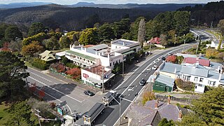
Blackheath is a town located near the highest point of the Blue Mountains, between Katoomba and Mount Victoria in New South Wales, Australia. The town's altitude is about 1,065 m (3,494 ft) AHD and it is located about 120 km (75 mi) west north-west of Sydney, 11 km (6.8 mi) north-west of Katoomba, and about 30 km (19 mi) south-east of Lithgow.

Great Western Highway is a 202-kilometre-long (126 mi) state highway in New South Wales, Australia. From east to west, the highway links Sydney with Bathurst, on the state's Central Tablelands. The highway also has local road names between the Sydney city centre and Parramatta, being: Broadway from Haymarket to Chippendale, Parramatta Road from Chippendale to Parramatta, and Church Street through Parramatta.

Lithgow is a town in the Central Tablelands of New South Wales, Australia and is the administrative centre of the City of Lithgow local government area. It is located in a mountain valley named Lithgow's Valley by John Oxley in honour of William Lithgow, the first Auditor-General of New South Wales.
Mount Victoria is a village in the Blue Mountains of New South Wales, Australia. Geographically, Mount Victoria is the westernmost village and suburb of Greater Sydney on the Great Western Highway in the City of Blue Mountains, located about 120 kilometres (75 mi) west-northwest by road from the Sydney central business district and at an altitude of about 1,052 metres (3,451 ft) AHD. At the 2021 Census, the settlement had a population of 945.

Hartley is a historical village in the Central West region of New South Wales, Australia, within the City of Lithgow local government area, located approximately 127 kilometres (79 mi) west of Sydney. Hartley is located below the western escarpment of the Blue Mountains.

Bells Line of Road is a 59-kilometre (37 mi) major road located in New South Wales, Australia, providing an alternative crossing of the Blue Mountains to the Great Western Highway. The eastern terminus of the road is in Richmond, 51 km northwest of Sydney, where the road continues eastward as Kurrajong Road, which intersects the A9. The western terminus of the road is in Bell, in the Blue Mountains, where the road continues as the Chifley Road.

Wolgan Valley is a small valley located along the Wolgan River in the Lithgow Region of New South Wales, Australia. The valley is located approximately 32 kilometres (20 mi) north of Lithgow and 150 kilometres north-west of Sydney. Accessible by the Wolgan Valley Discovery Trail from the Castlereagh Highway, the road travels through the valley leading onto the historical village of Newnes and its extensive industrial ruins.

St Marys is a small township nestled at the junction of the Tasman Highway and the Esk Highway on the East Coast of Tasmania, Australia approximately 10 kilometres from the coast.

Bell is a small rural and residential village in the Blue Mountains region of New South Wales, Australia. It is the north-westernmost village in the City of Blue Mountains, located approximately 125 kilometres (78 mi) west of Sydney central business district by road or 137 kilometres (85 mi) by rail, approximately 20 kilometres (12 mi) east of Lithgow and 10 kilometres (6.2 mi) north of Mount Victoria. It is a locality on the junction of the Bells Line of Road, Chifley Road and the Darling Causeway, with an elevation of approximately 1,100 metres (3,600 ft) AHD.

Mount York, a mountain in the western region of the Explorer Range, part of the Blue Mountains Range that is a spur off the Great Dividing Range, is located approximately 150 kilometres (93 mi) west of Sydney, just outside Mount Victoria in New South Wales, Australia. Mount York has an elevation of 1,061 metres (3,481 ft) AHD and is a projection of the Blue Mountains dissected plateau, creating a promontory of the western escarpment with a minor rise at its summit.

Hartley Vale is a small village in the Blue Mountains area of New South Wales, Australia. It is approximately 150 kilometres west of Sydney and 12 kilometres south-east of Lithgow. It is in the local government area of the City of Lithgow.
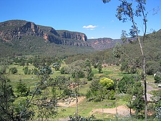
The Capertee Valley is a large canyon in New South Wales, Australia, 135 km (84 mi) north-west of Sydney that is noted to be the second widest of any canyon in the world, exceeding the Grand Canyon. It is located 135 km (84 mi) kilometres north-west of Sydney, between Lithgow and Mudgee, in the Central Tablelands, just above the Blue Mountains.
2LT is an Australian AM radio station based in Lithgow and serving the Central West, and Blue Mountains regions of New South Wales. It was opened in July 1939.

Mount Blaxland, actually a hill, is located about 15 kilometres south of Lithgow. It was the furthest point reached by Blaxland, Lawson, and Wentworth on their historic 1813 crossing of the Blue Mountains.

Woodford Academy is a heritage-listed former academy school, inn, private residence and boarding house and now a museum, and tourist attraction at 90-92 Great Western Highway, Woodford in the City of Blue Mountains local government area of New South Wales, Australia. It was built from 1828 to 1835 by Thomas Michael Pembroke. It is also known as Woodman's Inn, King's Arms Inn, Buss's Inn, Woodford House and Woodford Academy. The property is owned by the National Trust of Australia (NSW). It was added to the New South Wales State Heritage Register on 1 March 2002.
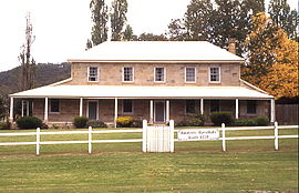
Collits' Inn is a heritage-listed former inn and now functions, accommodation and restaurant at Hartley Vale Road, Hartley Vale, City of Lithgow, New South Wales, Australia. It was designed by Pierce Collits and built in 1823. It is also known as Collitts Inn and Golden Fleece Inn. It was added to the New South Wales State Heritage Register on 2 April 1999.

Fernhill is a heritage-listed former house and former inn located beside the Great Western Highway in Bowenfels, City of Lithgow, New South Wales, Australia. It was built from 1856 to 1859 by John Blackman. It is also known as Australia Arms Inn. The property is owned by National Trust of Australia (NSW). It was added to the New South Wales State Heritage Register on 2 April 1999. On 18 July 2019 it was sold as a residential property.