The Great Western Highway is a 201-kilometre-long (125 mi) state highway in New South Wales, Australia. From east to west, the highway links Sydney with Bathurst, on the state's Central Tablelands.

Glenbrook is a township of the Lower Blue Mountains of New South Wales, Australia. It is located 70 kilometres west of Sydney in the local government area of the City of Blue Mountains. At the 2016 Australian census Glenbrook had a population of 5,051 people.

The City of Blue Mountains is a local government area of New South Wales, Australia, governed by the Blue Mountains City Council. The city is located in the Blue Mountains range west of Sydney.
The Mundaring Branch Railway is an historical section of the original Eastern Railway main line across the Darling Scarp in the Western Australian Government Railways (WAGR) system.

Lapstone is a township on the eastern escarpment of the Blue Mountains in New South Wales, Australia. Elevation 160 m (525 ft). Lapstone is located 62 kilometres west of the Sydney CBD in the local government area of the City of Blue Mountains and is part of the federal electorate of Macquarie. Lapstone consists mostly of stand-alone housing and has a few public facilities. At the 2016 census, Lapstone had a population of 961 people. Lapstone was originally bought and developed by Mr Arthur J Hand, an Alderman of the Blue Mountains City Council.

The Lapstone Zig Zag was a zig zag railway built between Emu Plains and Blaxland stations on the Main Western line of New South Wales in Australia. Constructed between 1863 and 1865 to overcome an otherwise insurmountable climb up the eastern side of the Blue Mountains, the zig zag and associated Knapsack Viaduct, a sandstone arch viaduct, were designed by John Whitton, Engineer-in-Charge of New South Wales Government Railways, and were built by William Watkins. The zig zag was listed on the Blue Mountains local government heritage register on 27 December 1991; while the adjacent Knapsack Viaduct was listed on the New South Wales Heritage Database on 2 April 1999. The Lapstone ZigZag was the world-first ZigZag constructed on any main-line railway.

The Blue Mountains Line (BMT) is an inter urban commuter rail service operated by NSW TrainLink serving the Blue Mountains region of New South Wales, Australia. The line travels west from Sydney to the major town of Katoomba and on to Mount Victoria, Lithgow and Bathurst. Mount Victoria is the terminus for most electric services, but some services terminate at Lithgow instead. 2 Express services per day in each direction, known as the Bathurst Bullet, extend to the regional city of Bathurst, which is supplemented by road coaches connecting Bathurst to Lithgow. Due to electrification limits at Lithgow, the Bathurst Bullet is run using the Endeavour railcars, which operate on diesel. The Blue Mountains Line operates over a mostly duplicated section of the Main Western line. As such, the tracks are also traversed by the Central West XPT, Outback Xplorer and Indian Pacific passenger services and by freight trains.

RAAF Base Glenbrook is a Royal Australian Air Force (RAAF) base located in Glenbrook, in the Lower Blue Mountains, approximately 60 kilometres (37 mi) west of the Sydney central business district in New South Wales, Australia.

John Whitton, an Anglo–Australian railway engineer, was the Engineer-in-Charge for the New South Wales Government Railways, serving between 1856 and 1890, considered the Father of New South Wales Railways. Under his supervision, it is estimated that 2,171 miles (3,494 km) of railway around New South Wales and Victoria were completed. Whitton was responsible for the construction of parts of the Main Western railway line, in particular the section over the Blue Mountains and the Lithgow Zig Zag, and much of the Main Southern railway line.

Wollondilly Shire is a periurban local government area adjacent to the south-western fringe of Sydney, parts of which fall into the Macarthur, Blue Mountains and Central Tablelands regions in the state of New South Wales, Australia. Wollondilly Shire was created by proclamation in the NSW Government Gazette on 7 March 1906, following the passing of the Local Government (Shires) Act 1905, and amalgamated with the Municipality of Picton on 1 May 1940.
The Main Western Railway is a major railway in New South Wales, Australia. It runs through the Blue Mountains, Central West, North West Slopes and the Far West regions. It is 825 kilometres (513 mi) with 484 kilometres (301 mi) operational & 341 kilometres (212 mi) under construction & repairs.

The Ardglen Tunnel, also called the Liverpool Range tunnel, is a heritage-listed summit rail tunnel located on the Main North railway between Ardglen in the Liverpool Plains Shire and Murrurundi in the Upper Hunter Shire local government area, both in New South Wales, Australia. The tunnel crosses under the Liverpool Range near its east end, below Nowlands Gap, the crossing used by the New England Highway, and provides a vital link between Newcastle and Werris Creek. The tunnel was completed in 1877 and is owned by the Transport Asset Holding Entity, a state-owned corporation of the Government of New South Wales. It was added to the New South Wales State Heritage Register on 2 April 1999.

The Lithgow Zig Zag is a heritage-listed former zig zag railway line built near Lithgow on the Great Western Line of New South Wales in Australia. The zig zag line operated between 1869 and 1910, to overcome an otherwise insurmountable climb and descent on the western side of the Blue Mountains. It was designed by John Whitton and built from 1863 to 1869 by Patrick Higgins as contractor. It is also known as the Great Zig Zag Railway and Reserves and Zig Zag Railway. The property is owned by Department of Planning and Infrastructure. It was added to the New South Wales State Heritage Register on 2 April 1999.

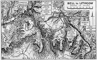
The Ten Tunnels Deviation is a heritage-listed 9.2-kilometre (5.7 mi) section of the Main Western Line between Newnes Junction and Zig Zag stations in Lithgow, New South Wales, Australia. It was designed and built by the New South Wales Government Railways and built from 1 June 1908 and 16 October 1910. It is also known as Great Zig Zag Railway deviation tunnels and Bell to Zig Zag Ten Tunnel Railway Deviation. It was added to the New South Wales State Heritage Register on 2 April 1999.
The Glenbrook deviation was a section of track on the Main Western line from the first Knapsack Viaduct to old Glenbrook station in the Blue Mountains of New South Wales, Australia. The approximately five-mile-long (eight-kilometre) deviation was constructed from 1891 to 1892 and replaced the Lapstone Zig Zag. The deviation was closed in 1913 when it was replaced by the second Glenbrook deviation and the second Glenbrook Tunnel, that continues to carry the Main Western line today.

Glenbrook Creek is a freshwater tributary of the Nepean River. It is located within the Blue Mountains of New South Wales, Australia.

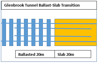
The Glenbrook Tunnel is a heritage-listed single-track former railway tunnel and mustard gas storage facility and now mushroom farm located on the former Main Western Line at the Great Western Highway, Glenbrook, in the City of Blue Mountains local government area of New South Wales, Australia. The Department of Railways designed the tunnel and built it from 1891 to 1892. It is also known as Lapstone Hill tunnel and Former Glenbrook Railway and World War II Mustard Gas Storage Tunnel. The property is owned by Blue Mountains City Council and Land and Property Management Authority, an agency of the Government of New South Wales. It was added to the New South Wales State Heritage Register on 5 August 2011. The railway tunnel was originally part of the Glenbrook 1892 single-track deviation, which bypassed the Lapstone Zig Zag across the Blue Mountains. It is 634 metres; 693 yards long and is constructed in an 'S' shape with a gradient of 1:33.

The Rydal rail underbridges are a series of heritage-listed railway underbridges and viaducts that carry the Main Western line over Solitary Creek at Rydal, in the City of Lithgow local government area of New South Wales, Australia. The property is owned by RailCorp, an agency of the Government of New South Wales. It was added to the New South Wales State Heritage Register on 2 April 1999.
The Glenbrook deviation is a section of track on the Main Western line from Emu Plains to Blaxland stations in the Blue Mountains of New South Wales, Australia. The approximately seven-mile-long (eleven-kilometre) double-track deviation was constructed from 1911 to 1913 and replaced the single-track first Glenbrook deviation and the first Glenbrook Tunnel.


