Winmalee, New South Wales

Last updated

Winmalee
New South Wales
Hawkesburylookout.JPG
View from Hawkesbury Lookout, Hawkesbury Heights
Australia New South Wales location map blank.svg
Red pog.svg
Winmalee
Winmalee, New South Wales
Coordinates 33°40′21″S150°37′08″E / 33.67250°S 150.61889°E / -33.67250; 150.61889
Population6,202 (2016 census) [1]
Established1972
Postcode(s) 2777
Elevation310 m (1,017 ft)
Location
LGA(s) City of Blue Mountains
State electorate(s) Blue Mountains
Federal division(s) Macquarie
Localities around Winmalee:
Faulconbridge Yarramundi Hawkesbury Heights
Faulconbridge Winmalee Hawkesbury Heights
Springwood Springwood Hawkesbury Heights

Winmalee is a town in New South Wales, Australia. Winmalee is located 77 kilometres west of the Sydney CBD, in the local government area of the City of Blue Mountains. At the 2011 census, Winmalee had a population of 6,593. [2]

Contents

Originally known as North Springwood, Winmalee was officially established in 1972. Springwood is historically significant as the first European settlement in the Blue Mountains. Winmalee is surrounded by Blue Mountains National Park. This National Park is on the World Heritage List and is known as the Greater Blue Mountains Area World Heritage Site. The Blue Mountains area is unofficially known as "The City Within a World Heritage National Park". Winmalee extends from Birdwood Avenue and Paulwood Avenue to Coramandel Avenue and east to a point part-way along Singles Ridge Road.

History

It is commonly believed that Winmalee is an Aboriginal word for north. But, as Aboriginal cultures did not use north, south, east or west, this is doubtful. It is more likely a corruption of the word Wimlah, the name of one of the Three Sisters, a rock formation 35 km to the west.[ citation needed ] The name was coined by a 14-year-old, who won a competition to find a name for North Springwood when the Geographical Names Board wanted to remove the compass prefixes from the names of towns and suburbs of New South Wales.[ citation needed ]

Aboriginal heritage

The area now officially known as Winmalee was once inhabited by Aboriginal Australians known as the Dharug tribe. This was a nomadic tribe which inhabited much of the Lower Blue Mountains until European colonisation and settlement. The dialect spoken by the tribe is known as the Dharug language. Current figures[ when? ] place the date of this settlement as beginning up to 50,000 years ago.

Except for a small number of descendants there are no members of the Dharug tribe now living in the area. The majority of this group were thought to have moved northward in the Blue Mountains and to have merged with the Gundungurra tribe. Others are thought to have been wiped out during European exploration and settlement. Archaeological evidence from the aboriginal inhabitants is common throughout Winmalee and includes several open sites and occupation shelters. [3]

European settlement

In 1970, the Geographical Names Board of New South Wales suggested that the area which had been unofficially known as 'North Springwood' be made an independent suburb of the Blue Mountains and renamed 'White Cross' because of the rapidly increasing population growth of Springwood. However residents of the area objected to the name 'White Cross'.

In 1971, the Department of Education selected "Winmalee" as the name for a new school in the area. Though the residents of the area approved this as the name for the proposed school they rejected it as a name for the suburb. The name Winmalee was chosen by the Department of Education as the result of a competition that had been organised amongst the local people. Terry Macauley, who was to be one of the school's original primary students, suggested the name "Winmalee", a supposed Aboriginal word for North. [4] The word was in fact never used by the Dharug people in relation to the area, but is instead a reference to its previous unofficial name.

Winmalee was finally officially established as an independent town on 28 April 1972 after the Minister for Lands, Tom Lewis MLA announced the suburb's independence from Springwood and approved the name Winmalee despite objections from residents.

October 2013 bushfires

The town, the nearby village of Yellow Rock and a small part of the adjacent town of Springwood were badly affected by a bushfire which started on 17 October 2013. 196 residential properties were destroyed, and 109 damaged. [5] 40 homes were destroyed on Buena Vista Road in Winmalee alone. [6]

Schools

High schools

Primary schools

Churches

Winmalee is the site of the 'Holy Monastery of St George', a monastic community for men under the Greek Orthodox Archdiocese of Australia.[ citation needed ]

Other churches in Winmalee include:

Parks and recreation

Summerhayes Park is a public reserve which is used for sport and recreational activities. Its facilities include tennis and netball/basketball courts, a skate park, outdoor gym equipment and fields for Football (soccer) both local (NDSFA) and Representative (FNSW) all year round. It is the home of Springwood United Football Club (formally Springwood Soccer & Sports Club), [13] Winmalee Netball Club, [14] Springwood Netball Club and a variety of other clubs. Summerhayes Park has a rich diversity of native flora and fauna and contains many threatened or endangered species and ecological communities. It is also a great bushwalking area with many interesting tracks, vistas and aboriginal archeological sites

Commercial areas

The Winmalee Village centre was officially opened in the early 1980s and refurbished in 2005. It comprises 22 specialty shops including Coles Supermarket and other specialty shops. [15] There are also other smaller shopping districts. There is a small strip mall located on Hawkesbury Road with a Caltex petrol station, car mechanic, takeaway shop, butcher, hair salon and a general store. The Australia Post office has moved to the Winmalee Village Centre. [16] There is also another very small shopping area, near the Village Centre, with a pizza shop, hairdressers and a gymnasium.

Winmalee Rural Fire Brigade

Winmalee Rural Fire Brigade is one of many Volunteer Fire Brigades located in New South Wales. The Brigade is a part of the NSW Rural Fire Service and started life as North Springwood Bush Fire Brigade in 1962. It currently has about 50 operationally active members with a reserve of approximately 150 people, with a total fire fighting experience in excess of 2200 years. Winmalee Rural Fire Brigade is a unique Brigade within the Blue Mountains Area as it is classed as a Village 2 Brigade which means it has an Urban Pumper Plus it carries Compressed Air Breathing Apparatus.

The brigade was heavily involved in the 2013 NSW Bushfires. [17]

Population

In the 2016 Census there were 6,202 people residing in Winmalee (51.7% female, 48.3% male). The population consisted of 82.9% born in Australia, including 2.3% Aboriginal or Torres Strait Islander. 5.1% were born in England, 1.1% New Zealand, 0.8% Scotland, 0.7% United States and 0.6% Germany. In the voluntary question about religion, the most common responses in Winmalee were No Religion, 29.1%, Catholic 25.4%, Anglican 20.2%, Not stated 6.2% and Presbyterian and Reformed 4.3%. Christianity was the largest religious group reported overall (66.6%) in Winmalee. [18]

Related Research Articles

<span class="mw-page-title-main">Warrimoo, New South Wales</span> Town in New South Wales, Australia

Warrimoo is a medium-sized village in the lower Blue Mountains of New South Wales, Australia, 273 metres above sea level. The state government's electorate is Blue Mountains and the state member is Labor's Trisha Lee Doyle.

<span class="mw-page-title-main">Eastwood, New South Wales</span> Suburb of Sydney, New South Wales, Australia

Eastwood is a suburb of Sydney, Australia. Eastwood is located 17 kilometres north-west of the Sydney central business district in the local government areas of the City of Ryde and the City of Parramatta. Eastwood is in the Northern Sydney region and is on the Sydney Trains Northern Line (Sydney). despite it being partially in the City of Parramatta. The area is best known for being an ethnic enclave for immigrant populations in Sydney, mainly of East Asian origin but the suburb also has a significant number of other immigrant populations, such as Italian and Anglo-Saxon people. Eastwood was originally its own town but due to the expansion of Sydney, was eventually absorbed.

<span class="mw-page-title-main">Blaxland, New South Wales</span> Town in New South Wales, Australia

Blaxland is a town in the Blue Mountains of New South Wales, Australia. Blaxland is located 65 kilometres west of Sydney in the local government area of the City of Blue Mountains. It is at an altitude of 234 metres and borders the townships of Glenbrook, Mount Riverview and Warrimoo.

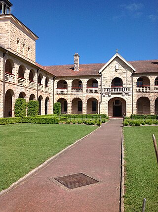
St Thomas Aquinas Church is a Roman Catholic church building located in Springwood, New South Wales, Australia. The church shares its grounds with the St Thomas Aquinas Primary School.

<span class="mw-page-title-main">Springwood, New South Wales</span> Town in New South Wales, Australia

Springwood is a town in the Blue Mountains, New South Wales, Australia. Springwood is located 72 kilometres west of the Sydney CBD in the local government area of the City of Blue Mountains. At the 2021 census, Springwood had a population 8,423 people.

Hazelbrook is a town in New South Wales, Australia It is located 91 kilometres west of Sydney and 16 kilometres east of Katoomba in the Blue Mountains on the Great Western Highway.

Valley Heights is a small township of the City of Blue Mountains in New South Wales, Australia. It is about 70 km (43 mi) from the Sydney central business district and is located east of the township of Springwood. At the 2006 census, Valley Heights had a population of 1,337 people.

<span class="mw-page-title-main">Jannali</span> Suburb of Sydney, New South Wales, Australia

Jannali is a suburb in southern Sydney, in the state of New South Wales, Australia. Jannali is located 28 kilometres south of the Sydney central business district in the local government area of the Sutherland Shire. The majority of land use in Jannali is residential and bushland reserve, while the suburb is bisected by the north–south railway line. The majority of Jannali's enterprises are located close to the suburb's railway station.

<span class="mw-page-title-main">Barden Ridge, New South Wales</span> Suburb of Sydney, New South Wales, Australia

Barden Ridge is a suburb in southern Sydney, in the state of New South Wales, Australia. Barden Ridge is located 29 kilometres south of the Sydney central business district in the local government area of the Sutherland Shire. Barden Ridge is colloquially known to locals as 'The Ridge'.

<span class="mw-page-title-main">Woronora</span> Suburb of Sydney, New South Wales, Australia

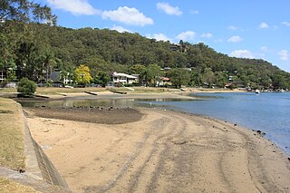
Woronora is a suburb in southern Sydney, in the state of New South Wales, Australia. Woronora is located 27 kilometres south of the Sydney central business district, in the local government area of the Sutherland Shire. Woronora Heights is a separate suburb, to the south-west.

<span class="mw-page-title-main">St Clair, New South Wales</span> Suburb of Sydney, New South Wales, Australia

St Clair is a suburb of Sydney, in the state of New South Wales, Australia. It is 44 kilometres west of the Sydney central business district, in the local government area of the City of Penrith and is part of the Greater Western Sydney region. St Clair is within view of the Blue Mountains.

<span class="mw-page-title-main">Werrington County, New South Wales</span> Suburb of Sydney, New South Wales, Australia

Werrington County is a suburb of Sydney, in the state of New South Wales, Australia. It is 50 kilometres (31 mi) west of the Sydney central business district, in the local government area of the City of Penrith and is part of the Greater Western Sydney region. The suburb is entirely residential with a high proportion of individual separate dwellings.

Berowra Heights is an outer suburb of Northern Sydney, in the state of New South Wales, Australia 39 kilometres north of the Sydney central business district, in the local government area of Hornsby Shire. Berowra Heights is north-west of the suburb of Berowra and east of Berowra Waters.

<span class="mw-page-title-main">Mount Riverview, New South Wales</span> Town in New South Wales, Australia

Mount Riverview is a town off the Great Western Highway about 2 km NE of Blaxland in the Lower Blue Mountains, New South Wales, 70 kilometres west of the Sydney CBD, Australia. At the 2006 census, Mount Riverview had a population of 2,993 people.

<span class="mw-page-title-main">Kurrajong, New South Wales</span> Town in New South Wales, Australia

Kurrajong is a small town in New South Wales, Australia. Kurrajong is located 75 kilometres (47 mi) north-west of Sydney, in the local government area of the City of Hawkesbury.

<span class="mw-page-title-main">St Columba's Catholic College</span> School in Australia

St Columba's Catholic College, formerly St Columba's High School, is an independent Roman Catholic co-educational secondary day school, located in the Blue Mountains region, on the border of Winmalee and Springwood, in New South Wales, Australia.

Hawkesbury Heights is a small town in the state of New South Wales, Australia in the City of Blue Mountains. It is located between the townships of Yarramundi and Winmalee. To the south is Yellow Rock. The only road link to the suburb is Hawkesbury Road, which becomes Springwood Road to the east.

Yellow Rock is a small village or locality in the Blue Mountains region of New South Wales, Australia. At the 2011 census, Yellow Rock had a population of 1029.

<span class="mw-page-title-main">Bilpin, New South Wales</span> Suburb of City of Hawkesbury, New South Wales, Australia

Bilpin is a small town on the historic Bells Line of Road in the City of Hawkesbury local government area in the Blue Mountains, west of Sydney, New South Wales.

<span class="mw-page-title-main">2013 New South Wales bushfires</span>

The 2013 New South Wales bushfires were a series of bushfires in Australia across the state of New South Wales primarily starting, or becoming notable, on 13 October 2013; followed by the worst of the fires beginning in the Greater Blue Mountains Area on 16 and 17 October 2013.

References

  1. Australian Bureau of Statistics (27 June 2017). "Winmalee (State Suburb)". 2016 Census QuickStats. Retrieved 24 April 2018. OOjs UI icon edit-ltr-progressive.svg
  2. Australian Bureau of Statistics (31 October 2012). "Winmalee (State Suburb)". 2011 Census QuickStats. Retrieved 30 November 2014. OOjs UI icon edit-ltr-progressive.svg
  3. "Cycling - City of Sydney".
  4. Winmalee Public School Retrieved 5 February 2007
  5. "Watch and Act - Linksview Road Fire, Springwood (Blue Mountains) 19/10/13 11:40". NSW Rural Fire Service. 19 October 2013. Retrieved 19 October 2013.
  6. McGrath, Pat (19 October 2013). "Winmalee residents share stories of survival and loss as they return to bushfire-ravaged homes". Australian Broadcasting Corporation. Retrieved 19 October 2013.
  7. "St Columbas School High, Springwood", Catholic Education Office Parramatta. Retrieved 25 February 2007
  8. "Dept. of Education and Training - Schools Hosting". Archived from the original on 19 May 2001.
  9. Ellison Public School Retrieved 24 January 2007
  10. http://springwoodanglican.org.au/ Anglican Churches Springwood
  11. http://www.springwoodchurch.org.au/ Springwood Winmalee Presbyterian Church
  12. http://www.christianbrethren-nsw.org.au/ Christian Brethren in NSW
  13. "Springwood United Football Club Inc".
  14. "Archived copy". Archived from the original on 25 September 2008. Retrieved 8 October 2008.{{cite web}}: CS1 maint: archived copy as title (link)
  15. "Winmalee Village shopping centre located in NSW Australia, opening hours, store list, parking, contact". Australia Shoppings. Retrieved 21 August 2023.
  16. "Find a Post Office, street posting box, Parcel Locker or Parcel Collect location". auspost.com.au. Retrieved 22 August 2023.
  17. Donnison, Jon (18 October 2013). "Australian wildfires raze homes in New South Wales". BBC News.
  18. "2016 Census QuickStats Winmalee". Australian Bureau of Statistics. Australian Government. Retrieved 25 October 2017.