Grose Valley

Last updated

Map all coordinates using: OpenStreetMap  
Download coordinates as: KML
Grose
Grose Valley, NSW, Australia - April 2013.jpg
View from Govetts Leap
Australia New South Wales location map blank.svg
Red pog.svg
Grose
Area50,200 km2 (19,400 sq mi)
Geography
CountryAustralia
StateNew South Wales
Regions Sydney Basin (IBRA) and Blue Mountains
Local government area Blue Mountains
Mountain rangeExplorers Range,
Great Dividing Range
RiverGrose River

The Grose Valley is a rugged valley in the Blue Mountains, New South Wales, Australia. It has been formed by the Grose River, the headwaters of which are in the Mount Victoria area. The valley is located between the Great Western Highway and Bells Line of Road, the two major routes across the Blue Mountains. The majority of the valley falls within the Blue Mountains National Park.

Contents

Grose wilderness features

A stream in the Grose Valley. Grose valley in the valley.JPG
A stream in the Grose Valley.

The Grose Wilderness contains some of the most dramatic gorge and canyon landscapes of the entire Sydney basin sandstone region. The Grose also constitutes one of the most accessible wilderness areas for bushwalking or public observation from its escarpment margins.

Geology

The geology of the area consists of Triassic sandstones and underlying Permian sedimentary rocks. A number of basalt-capped peaks dominate the area, notably Mount Banks and Mount Hay. The Grose River and its tributaries have eroded an extensive labyrinth of gorges and canyons through the Hawkesbury (upper) and Narrabeen (lower) group sandstones, exposing cliffs of commonly over 200 metres (660 ft) and up to 510 metres (1,670 ft) in height (Banks Wall). The Burramoko Head sandstone in the upper and middle Grose gorges possesses weathering tendencies of breakage along vertical joints and has consequently yielded some of the sheerest cliff faces in the Blue Mountains. The wilderness contains 80% of the Grose River catchment. The river flows to the Nepean-Hawkesbury through an undisturbed environment for all but its final 5 kilometres (3.1 mi). Consequently, the Grose has substantial wild river values, as do its major tributaries such as Wentworth Creek and Carmarthen Brook. [1]

Victoria Cascades on Victoria Falls in the Grose Valley. VictoriaCascades.jpg
Victoria Cascades on Victoria Falls in the Grose Valley.

Flora

The bulk of the vegetation in the wilderness is dry open forest and woodland, dominated by Eucalyptus sieberi and E. piperita above 800 metres (2,600 ft) altitude with Eucalyptus oblonga , E. globoidea , E. agglomerata and Angophora costata becoming dominant at lower altitudes. Plateau areas have thinner or waterlogged soils and generally support heath or low open woodland communities. Within the sheltered and well watered canyon environments closed forests commonly occur, with typical species being coachwood, sassafras and possumwood. On the isolated basalt caps the fertile soils support taller eucalypt forests of E. viminalis , E. blaxlandii and E. fastigata . A small area of alluvial sediments deposited in the upper Grose Valley during the Quaternary supports a tall moist open forest dominated by E. deanei , E. oreades , E. notabilis and E. cypelocarpa . The Blue Gum Forest is included in this forest type. [1]

Fauna

The river is known habitat for platypus and certain hanging swamps provide habitat for the endangered and endemic Blue Mountains water skink ( Eulamprus leuraensis ). The rocky sandstone complexes of the plateau provide habitat for some specialised and rare native animal species (e.g. the broad-headed snake, Hoplocephalus bungaroides ). Woodland communities are habitat for mammals such as the red-necked swamp wallaby, brush-tailed rock wallaby and eastern pygmy possum. [1]

History

Aboriginal history

Aboriginal artefacts have been found close to the Blue Gum Forest.[ citation needed ]

European history

The Grose River has cut a deep gorge through the area as it makes its way east towards the Hawkesbury River. Sheer sandstone cliffs standing hundreds of metres above the river make for spectacular scenery and can be viewed extensively from the Blackheath area, where there are a number of accessible lookouts, the best known being Govetts Leap. [2] :259–262 The valley can also be viewed from lookouts near Bells Line of Road and points outside Mount Victoria. It is named after Francis Grose.

Charles Darwin described the Grose Valley as "stupendous… magnificent" when he visited in 1836. In 1859 some of the first photographs in Australia were taken in the valley. At various times there were proposals for rail lines and dams but these have not proceeded. In 1931, the valley was the subject of one of Australia's first forest conservation battles. [3] [4]

Within the valley, the Blue Gum Forest is one place that stands out from the rest of the valley. It consists predominantly of towering Blue Gum trees (Eucalyptus deanei, also known as Deane's Gums, or Broad-leafed gums), with a thin understorey because the tall trees inhibit the growth of ground cover by blocking most of the sunlight. Protected by the Blue Mountains National Park, the forest can be accessed only on foot, with several trails from different parts of the Grose Valley and adjacent canyons meeting in the forest. [2] :264

Grose Valley in Grose Wilderness. ANOU6559.jpg
Grose Valley in Grose Wilderness.

Bushwalking trails

BRIDAL VEIL FALLS.jpg
Bridal falls.JPG
Bridal Veil Falls near Govetts Leap
Waratah. A flower endemic to this region. AGAV6949.jpg
Waratah. A flower endemic to this region.

There are a number of walks through the valley, with various entry, exit points and valley arms offering a range of permutations to explore. A moderate-grade day walk covering approximately 10 kilometres (6 mi) in five hours starts at Perrys Lookdown and descends sharply to the valley floor. Crossing through a corner of the Blue Gum Forest, the track goes south through the Acacia Flat camp ground, following the Govetts Creek. Passing several abandoned campgrounds, the path forks at Junction Rock; the route to Govetts Leap was closed in October 2003, following a landslide, and was reopened in December 2007. In the other direction, along Govetts Creek, the route then starts a continuous climb towards the Grand Canyon, where it forks again; one track goes to Neates Glen, while the other is a steep climb to Evans Lookout. The general direction of travel is towards the southeast and this direction is recommended as the final climb at Evans Lookout is not as difficult as the ascent at Perrys Lookdown. Creeks in the valley are seasonal, the water is unsafe to drink. [5] The walk is much more strenuous in summer due to the higher daily temperatures and the added risk of bushfires.

The valley has been affected by bushfires at various times, notably in 1982 and in November 2006. In particular the Blue Gum Forest was damaged by back burning. Owing to the harsh bushfires in 2006, the Blue Gum forest and other walking tracks in the valley were closed to bushwalkers to allow the regrowth of vegetation. As of March 2009, all tracks in the Grose Valley are open, with the exception of the Rodriguez Pass into the valley from Evans lookout and the Grand Canyon, closed due to a landslide. [3] [6] [7]

Conservation

The Grose Valley arguably became the cradle of the modern conservation movement in NSW when Blue Gum Forest was saved from threatened destruction in 1931-32. A group from the Sydney Bush Walkers club, led by Alan Rigby, were camped in the forest when they chanced upon a Bilpin farmer, Clarrie Hungerford. Hungerford had a lease of the forest and told the bushwalkers he planned to clear the blue gums to plant walnuts. The bushwalkers went away and started a campaign to stop him. Eventually, they raised £130 which they paid Hungerford in exchange for his relinquishing the lease. It was a substantial amount at the height of the great depression. 80 pounds came in the form of an interest-free loan from James Cleary, then head of the NSW railways and subsequently chairman of the Australian Broadcasting Commission. Cleary was also a bushwalker. [8]

One of the key activists in the campaign was Myles Dunphy, who at the time was developing his plans for the Blue Mountains National Park.

During the 1800s there were various proposals to dam the Grose Valley, and one such dam would have been at the forest. The area was also the subject of a number of proposed coal and shale mining ventures, and in the 1850s it was planned that the main western railway line would be routed up the Grose River and through the forest. [9]

In 1875 Blue Gum Forest was the scene of an artists’ camp established by Eccleston Du Faur, of the Academy of Art. Several magnificent photographs by Joseph Philip Bischoff and drawings and paintings by William Piguenit resulted. Another outcome was that the whole Grose Valley and surrounds was reserved from alienation because it was ‘a national spectacle’. At the time there was no national park in Australia, and indeed Australia was not even a nation—but the reservation in essence was the country’s first national park. [10]

Grose Valley seen from Pulpit Rock, Blackheath Grose valley from ppit rock.jpg
Grose Valley seen from Pulpit Rock, Blackheath

Major tracks

The Blue Mountains National Park contains the following heritage-listed major walking tracks:

Major lookouts

See also

Map

Related Research Articles

Blue Mountains (New South Wales) Region in New South Wales, Australia

The Blue Mountains are a mountainous region and a mountain range located in New South Wales, Australia. The region borders on Sydney's metropolitan area, its foothills starting about 50 kilometres (31 mi) west of centre of the state capital, close to Penrith on the outskirts of Greater Sydney region. The public's understanding of the extent of the Blue Mountains is varied, as it forms only part of an extensive mountainous area associated with the Great Dividing Range. As defined in 1970, the Blue Mountains region is bounded by the Nepean and Hawkesbury rivers in the east, the Coxs River and Lake Burragorang to the west and south, and the Wolgan and Colo rivers to the north. Geologically, it is situated in the central parts of the Sydney Basin.

Heathcote National Park Protected area in New South Wales, Australia

Heathcote National Park is a protected national park that is located in the southern region of Sydney, New South Wales in eastern Australia, and is situated on Dharawal country. The 2,679-hectare (6,620-acre) national park is situated approximately 35 kilometres (22 mi) southwest of the Sydney central business district, west of the South Coast railway line, the Princes Highway and Motorway, and the suburbs of Heathcote and Waterfall.

Kanangra-Boyd National Park Protected area in New South Wales, Australia

The Kanangra-Boyd National Park is a protected national park that is located in the Central Tablelands region, west of the Southern Highlands and Macarthur regions, in New South Wales, in eastern Australia. The 68,660-hectare (169,700-acre) national park is situated approximately 180 kilometres (110 mi) south-west of Sydney and is contiguous with the Blue Mountains National Park and the Nattai National Park. The park was established in 1969.

Ku-ring-gai Chase National Park Protected area in New South Wales, Australia

Ku-ring-gai Chase National Park is a national park on the northern side of Sydney in New South Wales, Australia. The 14,977-hectare (37,010-acre) park is 25 kilometres (16 mi) north of the Sydney central business district and generally comprises the land east of the M1 Pacific Motorway, south of the Hawkesbury River, west of Pittwater and north of Mona Vale Road. It includes Barrenjoey Headland on the eastern side of Pittwater.

Oxley Wild Rivers National Park Protected area in New South Wales, Australia

The Oxley Wild Rivers National Park is a protected national park that is located in the Northern Tablelands region of New South Wales, Australia in the Port Macquarie-Hastings City Council and Walcha Shire councils. The 145,223-hectare (358,850-acre) park is situated 445 kilometres (277 mi) north of Sydney and is named in memory of the Australian explorer John Oxley, who passed through the area in 1818 and is one of the largest national parks in New South Wales.

Wollemi National Park Protected area in New South Wales, Australia

The Wollemi National Park is a protected national park and wilderness area that is located in the northern Blue Mountains and Lower Hunter regions of New South Wales, in eastern Australia. The 501,703-hectare (1,239,740-acre) park, the second largest national park in New South Wales, contains the 361,113-hectare (892,330-acre) Wollemi Wilderness – the largest such wilderness area in Australia – and is situated approximately 130 kilometres (81 mi) northwest of Sydney.

Blackheath, New South Wales Suburb of City of Blue Mountains, New South Wales, Australia

Blackheath is an Australian town located near the highest point of the Blue Mountains, between Katoomba and Mount Victoria in New South Wales. The town's altitude is about 1,065 metres (3,494 ft) AHD  and it is located about 120 kilometres (75 mi) west north-west of Sydney, 11 kilometres (6.8 mi) north-west of Katoomba, and about 30 kilometres (19 mi) south-east of Lithgow.

Jamison Valley valley in New South Wales Australia

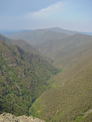
The Jamison Valley forms part of the Coxs River canyon system in the Blue Mountains of New South Wales, Australia. It is situated approximately 100 kilometres west of Sydney, capital of New South Wales, and a few kilometres south of Katoomba, the main town in the Blue Mountains.

Colo River River in New South Wales, Australia

The Colo River, a perennial stream that is part of the Hawkesbury-Nepean catchment, is located in the Central Tablelands of New South Wales, Australia.

The Wollemi Creek, a partly perennial stream of the Hawkesbury-Nepean catchment, is located in the Central Tablelands and Blue Mountains regions of New South Wales, Australia.

Perrys Lookdown

Perry's Lookdown is situated on the edge of the Grose Valley in the Blue Mountains, Australia. It is believed to have been named by Frederick Eccleston Du Faur after either Samuel Augustus Perry or a local innkeeper. Free campsites are adjacent to the car park. The Blue Gum Forest is often accessed by foot from here, 656 vertical metres below the lookdown. The road to Blackheath is unsealed.

Evans Lookout

Evans Lookout is a lookout in the Blue Mountains, New South Wales, Australia. Overlooking the sandstone cliffs of the Grose River Valley, the lookout is also an access point for pedestrian access to the valley floor.

The Nepean Gorge is a gorge on the Nepean River west of Sydney, New South Wales, Australia.

Narrow Neck Plateau

The Narrow Neck Plateau, an eroded remnant of a sandstone layer situated at an elevation of 1,000 metres (3,300 ft) above sea level that is part of the Blue Mountains Range which is a spur line off the Great Dividing Range, is situated immediately south-west of Katoomba in New South Wales, Australia, located within the Blue Mountains National Park. The neck separates the Jamison Valley from the Megalong Valley.

Grose River

The Grose River, a perennial river that is part of the Hawkesbury-Nepean catchment, is located in the Blue Mountains region of New South Wales, Australia.

The Kowmung River, a perennial river that is part of the Hawkesbury-Nepean catchment, is located in the Central Tablelands region of New South Wales, Australia.

Kanangra Creek

The Kanangra Creek, a perennial stream of the Hawkesbury-Nepean catchment, is located in the Blue Mountains region of New South Wales, Australia.

Bungonia National Park Protected area in New South Wales, Australia

Bungonia National Park is a protected national park that is located in the Australian state of New South Wales, roughly 40 kilometres (25 mi) east of the city of Goulburn and 122 km (76 mi) south-west of Sydney. The approximately 15 square kilometres (5.8 sq mi) park borders the Bungonia State Conservation Area to the South, Morton National Park to the East, and Bungonia Creek to the North. Only a relatively recent addition to the national parks registry, Bungonia was originally protected as a water reserve to prevent contamination of the Shoalhaven River in the mid-late 19th century.

Blue Gum Forest

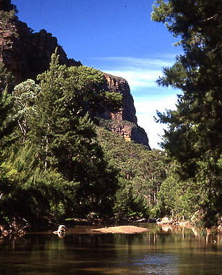
The Blue Gum Forest is a forest located in Blue Mountains National Park within the Grose Valley of the Blue Mountains in New South Wales west of Sydney, southeastern Australia. It is one of the best-known bushwalking sites in Australia. The forest is located within the UNESCO World Heritage Site known as the Greater Blue Mountains Area. The forest survived through the efforts of early Australian conservationists.

References

  1. 1 2 3 "Grose". NSW Wilderness Red Index. Colong Foundation for Wilderness. 1999. Retrieved 24 December 2013.
  2. 1 2 Paton, Neil (2004). Sydney and Blue Mountains Bushwalks. Kangaroo Press.
  3. 1 2 Borschmann, Gregg (11 December 2006). "The burning question". Sydney Morning Herald. Retrieved 12 December 2006.
  4. "Blue Mountains National Park: Culture & history". NSW National Parks & Wildlife Service. 2002. Archived from the original on 3 October 2006. Retrieved 12 December 2006.
  5. Duffy, Conor (17 May 2012). "Toxic metal contamination found in Grose Valley". Lateline. Retrieved 6 December 2014.
  6. Borschmann, Gregg (11 December 2006). "The ghosts of an enchanted forest demand answers". Sydney Morning Herald. Retrieved 12 December 2006.
  7. Macqueen, Andy (2007), Back from the brink : Blue Gum forest and the Grose Wilderness (2nd ed.), Andy Macqueen, ISBN   978-0-646-47695-7
  8. Macqueen, Part IV
  9. Macqueen, Parts I-II
  10. Macqueen, Parts III-IV
  11. "Blue Mountains Walking tracks". New South Wales State Heritage Register . Office of Environment and Heritage. H00980. Retrieved 18 May 2018.