
Milson Island is an island located in Sydney, New South Wales, Australia. It was first settled over 100 years ago and has been used as a bacteriological station, quarantine station, a hospital to treat soldiers from WWI with venereal disease, mental hospital, a rehab for alcoholics, a women's jail, and as of 2010, a sports and recreation centre. [1]
Contents
The island is in the Hawkesbury River, and the only means of transport is by ferry. Some of the activities available at Milson Island include a high ropes course, rock climbing, canoeing, kayaking, archery, bushwalking and abseiling. The accommodation is 3-4 stars with seven lodges and five holiday units. The camp usually suits two small schools or a big school at the same time. It is a popular camp for many schools across Sydney.[ citation needed ]
All that is left of the old mental asylum is the nurses' quarters or hospital. When the mental asylum was operating, an alarm system was set up, so that people on the island could keep themselves safe from escapees. The nurses' quarters are now rotted away, but the furnishings from the asylum still remain.
The Sport and Recreation Centre still uses the refurbished sleeping quarters as the dining room and kitchen. The rooms at Milson Island range from school kids' rooms that sleep up to five people to lodges for one to four people.
 Nurses Quarters Exterior 2019
 Nurses Quarters Interior 2019
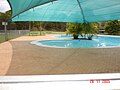 The Milson Island Pool
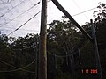 Milson Island high ropes challenge


