Blaxland Creek

Last updated

Blaxland
Creek [1]
Name origin:In honour of Gregory Blaxland [2]
Country Australia
Regions Sydney basin (IBRA), Greater Western Sydney
Local government area Penrith
Part of Hawkesbury-Nepean catchment
Source
 - location near Mulgoa
Mouth confluence with South Creek
 - location Orchard Hills
Length 10 km (6 mi)
[2]

Blaxland Creek, a watercourse [1] that is part of the HawkesburyNepean catchment, is located in Greater Western Sydney, Australia.

Hawkesbury River river in New South Wales, Australia

The Hawkesbury River, is a semi–mature tide dominated drowned valley estuary located to the west and north of Sydney, New South Wales, Australia. The Hawkesbury River and its associated main tributary, the Nepean River, virtually encircle the metropolitan region of Sydney.

Nepean River river in New South Wales, Australia

Nepean River, is a major perennial river, located in the south-west and west of Sydney, New South Wales, Australia. The Nepean River and its associated mouth, the Hawkesbury River, virtually encircle the metropolitan region of Sydney.

Greater Western Sydney Region in New South Wales, Australia

Greater Western Sydney (GWS) is a large region of the metropolitan area of Sydney, New South Wales, Australia that generally embraces the north-west, south-west, central-west, and far western sub-regions within Sydney's metropolitan area and encompasses 13 local government areas: Blacktown, Canterbury-Bankstown, Camden, Campbelltown, Cumberland, Fairfield, Hawkesbury, Hills Shire, Liverpool, Parramatta, Penrith, Wollondilly and the western portion of the City of Parramatta Council.

Contents

Course and features

Blaxland Creek rises in the western suburbs of Sydney, about 4 kilometres (2.5 mi) east south-east of Mulgoa and flows generally north by east, and then north-east by east before reaching its confluence with South Creek, in the suburb of Orchard Hills. The creek has a course of approximately 10 kilometres (6.2 mi).

Mulgoa is a village, located in the local government area of the City of Penrith, in the region of western Sydney, in the state of New South Wales, Australia. Mulgoa is located approximately 66 kilometres (41 mi) west of the Sydney central business district.

Confluence Meeting of two or more bodies of flowing water

In geography, a confluence occurs where two or more flowing bodies of water join together to form a single channel. A confluence can occur in several configurations: at the point where a tributary joins a larger river ; or where two streams meet to become the source of a river of a new name ; or where two separated channels of a river rejoin at the downstream end.

South Creek (New South Wales) river in New South Wales, Australia

The South Creek or Wianamatta, a creek that is part of the Hawkesbury-Nepean catchment, is located on the Cumberland Plain, also referred to as Greater Western Sydney, New South Wales, Australia.

Blaxland Creek, on Department of Defence land near Penrith, is probably the last near-pristine freshwater stream in the Cumberland Plain. Blaxland Creek, because it has been relatively untouched by development, can be used not only as a touchstone for understanding the biodiversity of other freshwater streams on the Cumberland Plain but as a way of reintroducing native species to other streams. [2] [3]

The Department of Defence is a department of the Government of Australia charged with the responsibility to defend Australia and its national interests. Along with the Australian Defence Force (ADF), it forms part of the Australian Defence Organisation (ADO) and is accountable to the Commonwealth Parliament, on behalf of the Australian people, for the efficiency and effectiveness with which it carries out the Government's defence policy.

Cumberland Plain plain in Australia

The Cumberland Plain is a relatively flat region lying to the west of Sydney CBD in New South Wales, Australia. Cumberland Basin is the preferred physiographic and geological term for the low-lying plain of the Permian-Triassic Sydney Basin found between Sydney and the Blue Mountains, and it is a structural sub-basin of the Sydney Basin.

The creek in named in honour of Gregory Blaxland, a pioneer farmer and explorer who was granted land in the Orchard Hills area from 1810. [2]

Gregory Blaxland English explorer in Australia

Gregory Blaxland was an English pioneer farmer and explorer in Australia, noted especially for initiating and co-leading the first successful crossing of the Blue Mountains by European settlers.

See also

Related Research Articles

Georges River river

The Georges River, formerly known as Tucoerah River, is an intermediate tide dominated drowned valley estuary, located to the south and west of Sydney, New South Wales, Australia.

Prospect Creek (New South Wales) river in New South Wales, Australia

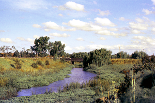
Prospect Creek, an urban watercourse of the Georges River catchment, is located in the western and Canterbury-Bankstown regions of Sydney, in New South Wales, Australia.

Geography of Sydney

The geography of Sydney is characterised by its coastal location on a basin bordered by the Pacific Ocean to the east, the Blue Mountains to the west, the Hawkesbury River to the north and the Woronora Plateau to the south. Sydney lies on a submergent coastline on the east coast of New South Wales, where the ocean level has risen to flood deep river valleys (rias) carved in the Sydney sandstone. Port Jackson, better known as Sydney Harbour, is one such ria.

Duck River (New South Wales) river in New South Wales, Australia

The Duck River is a perennial stream and southern tributary of the Parramatta River, in Sydney, New South Wales, Australia.

The Wonboyn River, an open youthful wave dominated barrier estuary or perennial stream, is located in the South Coast region of New South Wales, Australia.

Wamberal Lagoon, an intermittently closed intermediate saline coastal lagoon, is located on the Central Coast region of New South Wales, Australia. Wamberal Lagoon is located between the beachside settlements of Forresters Beach and Wamberal, and adjacent to the east coast, about 87 kilometres (54 mi) north of Sydney.

Avoca Lake lake in Australia

The Avoca Lake, formerly known as Avoca Lagoon and as Bulbararing Lagoon, is an intermittently closed intermediate saline coastal lagoon that is located on the Central Coast region of New South Wales, Australia. Avoca Lake is located between the beachside settlements of North Avoca and Avoca Beach, and adjacent to the east coast, about 85 kilometres (53 mi) north of Sydney.

Western Sydney Parklands Protected area in New South Wales, Australia

The Western Sydney Parklands is an urban park system and a nature reserve located in Sydney, New South Wales, Australia. The NSW government has spent around $400 million for the park. The park is governed by the NSW National Parks and Wildlife Service and is listed under the National Parks and Wildlife Act 1974. The Parklands begin in the north in the City of Blacktown, cross the City of Fairfield, and end in the City of Liverpool. The Parkland, being one of the largest in the world, features picnic areas, sports grounds and walking tracks. The parklands attract 430,000 to 790,000 visitors annually.

Dingo Creek, a perennial stream of the Manning River catchment, is located in the Mid North Coast region of New South Wales, Australia.

The Rush Creek, a perennial stream of the Hawkesbury-Nepean catchment, is located in the Outer Metropolitan Sydney region of New South Wales, Australia.

The Webbs Creek, a perennial stream of the Hawkesbury-Nepean catchment, is located in the Outer Metropolitan Sydney region of New South Wales, Australia.

Toongabbie Creek, an urban watercourse that is part of the Parramatta River catchment, is located in Greater Western Sydney, New South Wales, Australia.

Darling Mills Creek river in Australia

The Darling Mills Creek, an urban watercourse that is part of the Parramatta River catchment, is located in Greater Western Sydney, New South Wales, Australia.

Devlins Creek river in Australia

Devlins Creek, an urban watercourse that is part of the Parramatta River catchment, is located in Northern Suburbs region of Sydney, Australia.

Scout Creek river in Australia

Scout Creek, an urban gully that is part of the Parramatta River catchment, is located in Northern Suburbs region of Sydney, Australia.

Berowra Valley National Park Protected area in New South Wales, Australia

The Berowra Valley National Park is a protected national park that is located in northern Sydney, New South Wales, Australia. The 3,884-hectare (9,600-acre) national park is situated approximately 20 kilometres (12 mi) north-west of the Sydney central business district. Located within the Sydney Basin, the park is part of the dissected Hornsby Plateau which is dominated by Hawkesbury Sandstone and predominately covers the catchment area of Berowra Creek.

Jerra Jerra Creek

The Jerra Jerra Creek, a perennial stream of the Murray River catchment within the Murray-Darling basin, is located in the Riverina region of New South Wales, Australia.

Prospect Nature Reserve Protected area in New South Wales, Australia

Prospect Nature Reserve is a nature reserve and recreational area that is situated in the western suburbs of Sydney, New South Wales, Australia, which incorporates the Prospect Reservoir, and also features picnic spots, walking tracks and BBQ areas within the Australian bush. It is located within the Blacktown City local government area, but is also close to the boundaries of Cumberland Council and the City of Fairfield.

References

Coordinates: 33°49′S150°43′E / 33.817°S 150.717°E / -33.817; 150.717

Geographic coordinate system Coordinate system

A geographic coordinate system is a coordinate system that enables every location on Earth to be specified by a set of numbers, letters or symbols. The coordinates are often chosen such that one of the numbers represents a vertical position and two or three of the numbers represent a horizontal position; alternatively, a geographic position may be expressed in a combined three-dimensional Cartesian vector. A common choice of coordinates is latitude, longitude and elevation. To specify a location on a plane requires a map projection.