Related Research Articles

Rhodes is an Inner West suburb of Sydney, in the state of New South Wales, Australia. Rhodes is located 12 kilometres west of the Sydney central business district, in the local government area of the City of Canada Bay. It was formerly part of Concord Municipality until a merger with Drummoyne Council to form Canada Bay in December 2000.
The Parramatta River is an intermediate tide-dominated, drowned valley estuary located in Sydney, New South Wales, Australia. With an average depth of 5.1 metres (17 ft), the Parramatta River is the main tributary of Sydney Harbour, a branch of Port Jackson. Secondary tributaries include the smaller Lane Cove and Duck rivers.
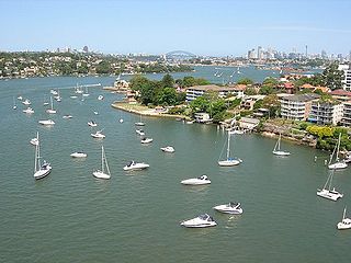
Homebush Bay is a bay on the south bank of the Parramatta River, in the west of Sydney, Australia. The name is also sometimes used to refer to an area to the west and south of the bay itself, which was formerly an official suburb of Sydney, and has now become the suburbs of Sydney Olympic Park, Wentworth Point and part of the neighbouring suburb of Lidcombe, all part of the City of Parramatta. Homebush Bay is located 13 kilometres (8.1 mi) west of the Sydney central business district.

Homebush is a suburb in the Inner West of Sydney in the state of New South Wales, Australia. It is located 12 kilometres west of the Sydney central business district, in the local government area of the Municipality of Strathfield.

The Municipality of Strathfield is a local government area in the West of Sydney, in the state of New South Wales, Australia.

The Inner West of Sydney is an area directly west of the Sydney central business district, New South Wales, Australia. The suburbs that make up the Inner West are predominantly located along the southern shore of Port Jackson, stretching south to the shores of the Cooks River. The western boundary of the Inner West is approximately the A3 arterial road, which divides the Inner West from the Greater Western Sydney region. The Inner West is much larger than the Inner West Council local government area. The Inner West roughly corresponds with the Parish of Petersham and Parish of Concord, two cadastral divisions used for land titles.

The A3 is a route designation of a major metropolitan arterial route through suburban Sydney, connecting the A8 at Mona Vale at its northern end, to Princes Highway at Blakehurst at its southern end. This name covers a few consecutive roads and is widely known to most drivers, but the entire allocation is also known – and signposted – by the names of its constituent parts: Mona Vale Road, Ryde Road, Lane Cove Road, Devlin Street, Church Street, Concord Road, Homebush Bay Drive, Centenary Drive, Roberts Road, Wiley Avenue and King Georges Road.

Parramatta Road is the major historical east-west artery of metropolitan Sydney, New South Wales, Australia, connecting the Sydney CBD with Parramatta. It is the easternmost part of the Great Western Highway. Since the 1990s its role has been augmented by the City West Link and M4 Motorway.
Strathfield is a suburb in Western Sydney, in the state of New South Wales, Australia. It is located 12 kilometres west of the Sydney central business district and is the administrative centre of the Municipality of Strathfield. A small section of the suburb north of the railway line lies within the City of Canada Bay, while the area east of The Boulevard lies within the Municipality of Burwood. North Strathfield and Strathfield South are separate suburbs to the north and south, respectively.

Rookwood is a suburb in western Sydney, in the state of New South Wales, Australia located 14 kilometres (8.7 mi) west of the Sydney central business district, in the local government area of the Cumberland Council. It is the easternmost suburb in greater western Sydney.

North Strathfield is a suburb in the inner-west of Sydney, in the state of New South Wales, Australia. North Strathfield is located 15 kilometres west of the Sydney central business district, in the local government area of the City of Canada Bay. Strathfield and Strathfield South are separate suburbs, to the south.

The Cooks River, a semi-mature tide-dominated drowned valley estuary, is a tributary of Botany Bay, located in south-eastern Sydney, New South Wales, Australia.

Flemington, officially gazetted as "Homebush West" since 1992, is a suburb in the Inner West of Sydney, in the state of New South Wales, Australia. Flemington is located 13 kilometres west of the Sydney central business district, in the local government area of the Municipality of Strathfield, with a small unpopulated area in Cumberland Council.

The M4 Motorway is a 55-kilometre (34 mi) series of partially-tolled dual carriageway motorways in Sydney, New South Wales designated as route M4. The M4 designation is part of the wider A4 and M4 route designation, the M4 runs parallel and/or below ground to Great Western Highway, Parramatta Road and City West Link, which are part of route A44.

The Sydney Markets are a group of wholesale and retail markets in Sydney, New South Wales, Australia. The Sydney Markets are located in the Inner West suburb of Flemington, New South Wales, 16 kilometres west of the Sydney central business district. Flemington is in the local government area of the Municipality of Strathfield. The market is the primary distribution hub of fresh produce, flowers and other food products for Sydney. The market has a wholesale sales section that caters to larger businesses and general sales to the public. The market is the central marketplace for Sydney's farmers to sell their products. It has a history dating back to 1788. The operator of the markets is Sydney Markets Limited, formerly the Sydney Markets Authority, but privatised in 1997. As well as the markets at Flemington, Sydney Markets Limited also operates the inner city Paddy's Market in Haymarket.
Powells Creek, a southern tributary of the Parramatta River, is an urban stream west of Sydney Harbour, located in Sydney, Australia. It flows through Sydney Olympic Park and joins Parramatta River at Homebush Bay.

Haslams Creek, a southern tributary of the Parramatta River, is a creek west of Sydney Harbour, located in Sydney, Australia. It flows through Sydney Olympic Park and joins Parramatta River at Homebush Bay. In 1793, the first grants were made to free settlers, with Samuel Haslam receiving his first grant in 1806. A 50 acre grant north of Parramatta Road, the first grant, was followed by a second small grant south of Parramatta Road and east of Haslams Creek. Haslams Creek flowed through the holdings of the Sydney Meat Preserving Company Ltd 1876-1965, which at one point damned the creek. When opened, Lidcombe railway station actually bore the name Haslams Creek Station

Wentworth Point is a suburb of Sydney, in the state of New South Wales, Australia. It is located 13 kilometres west of the Sydney central business district, on the eastern edge of the local government area of City of Parramatta. It is on the western shore of Homebush Bay on the southern side of the Parramatta River. Wentworth Point is usually regarded as part of the Greater Western Sydney region, including in administrative contexts, but it is also regarded as part of the Inner West region of Sydney in some contexts, especially commercial contexts.

The Olympic Park railway line is a railway line linking the Sydney Olympic Park precinct to the Main Suburban railway line at Flemington and Lidcombe. Originally opened as the Abattoirs branch in 1911, it was rebuilt and reopened as the Olympic Park railway line in 1998. Passenger services have since been running on it as the Olympic Park Line.
The Cooks River cycleway, also called the Bay to Bay Shared Pathway, is a 30-kilometre-long (19 mi) shared use path for cyclists and pedestrians in the Inner West of Sydney, New South Wales, Australia. The north-western terminus of the cycleway is in Settlers' Park, Ryde, from where it proceeds south, crossing the Parramatta River and skirting Homebush Bay to the Cooks River, from where it generally follows the course of the river south and east to the south-eastern terminus on Botany Bay at Kyeemagh. The alternative name "Bay to Bay" or "B2B" path refers to Homebush Bay and Botany Bay. The path connects a series of parklands in the City of Ryde and the Municipality of Strathfield, as well as the riverside green spaces along the course of the Cooks River.
References
- ↑ Powells Creek Landscape Design Framework, Volume 2.
- 1 2 3 4 5 Stephen Ambrose, Vertebrate Fauna Study for the Strathfield LGA, April 2009.
- ↑ "Strathfield Council web site: photograph". Archived from the original on 30 October 2009. Retrieved 16 March 2010.
- ↑ Strathfield Council management plan 2005/06–2007/08.
- ↑ New South Wales. Dept. of Labour and Industry and Social Services, The New South Wales Industrial Gazette, Volume 43, 1933, p. 26.
- ↑ Strathfield Council: Mason Park Plan of Management, p. 15. Archived 2011-06-15 at the Wayback Machine
- ↑ Cathy Jones, 'Airey Park History', Strathfield District Historical Society web site.
- ↑ Strathfield Council: Mason Park Plan of Management, pages 16, 19, 21 & 63. Archived 2011-06-15 at the Wayback Machine
- ↑ New South Wales. Olympic Co-ordination Authority, Homebush Bay Ecological Studies, 1993-1995, Volume 2, ISBN 0-643-05860-5, pp. 46–48.