
Caringbah is a suburb in southern Sydney, in the state of New South Wales, Australia. Caringbah is 24 kilometres (15 mi) south of the Sydney central business district in the local government area of Sutherland Shire.

Gymea is a suburb in southern Sydney, in the state of New South Wales, Australia. Gymea is located 26 kilometres south of the Sydney central business district in the local government area of the Sutherland Shire. The postcode is 2227, which it shares with adjacent suburb Gymea Bay.

The Sutherland Shire is a local government area in the southern region of Sydney, in the state of New South Wales, Australia. The Sutherland Shire is colloquially known as "The Shire" and it has been featured in several reality television series.

Port Stephens, an open youthful tide-dominated drowned-valley estuary, is a large natural harbour of approximately 134 square kilometres (52 sq mi) located in the Hunter Region of New South Wales, Australia.

Cronulla is a beachside suburb of Sydney, in the state of New South Wales, Australia. Boasting numerous surf beaches and swimming spots, the suburb attracts both tourists and Greater Sydney residents. Cronulla is located 26 kilometres south of the Sydney central business district, in the local government area of the Sutherland Shire.

Brighton Le Sands, is a suburb in southern Sydney, in the state of New South Wales, Australia. Brighton Le Sands is located 13 kilometres south of the Sydney central business district, on the western shore of Botany Bay. Brighton Le Sands is in the local government area of the Bayside Council and is part of the St George area.
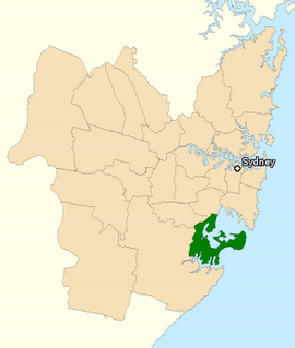
The Division of Cook is an Australian electoral division in the State of New South Wales.
Grays Point is a small affluent suburb in Southern Sydney, in the state of New South Wales, Australia 29 kilometres south of the Sydney central business district, in the local government area of the Sutherland Shire.

Yowie Bay is a suburb in southern Sydney, in the state of New South Wales, Australia. Yowie Bay is located 24 kilometres south of the Sydney central business district, in the local government area of the Sutherland Shire.
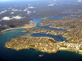
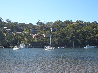
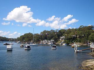
Port Hacking Estuary, an open youthful tide dominated, drowned valley estuary, is located in southern Sydney, New South Wales, Australia approximately 30 kilometres (19 mi) south of Sydney central business district. Port Hacking has its source in the upper reaches of the Hacking River south of Helensburgh, and several smaller creeks, including South West Arm, Bundeena Creek and The Basin and flows generally to the east before reaching its mouth, the Tasman Sea, south of Cronulla and north–east of Bundeena. Its tidal effect is terminated at the weir at Audley, in the Royal National Park. The lower estuary features a substantial marine delta, which over time has prograded upstream. There is also a substantial fluvial of the Hacking River at Grays Point. The two deltas are separated by a deep basin.
Lilli Pilli is a small suburb in southern Sydney, in the state of New South Wales, Australia. Lilli Pilli is located 26 kilometres south of the Sydney central business district, in the local government area of the Sutherland Shire. There is also another Lilli Pilli in New South Wales, located 12 kilometres south of Batemans Bay.

The Hacking River is a watercourse that is located in the Southern Sydney region of New South Wales in Australia. For thousands of years traditional owners called the river Deeban, however the colonial invaders renamed the river after Henry Hacking, a British seaman who killed Pemulwuy and was a pilot at Port Jackson in colonial New South Wales.

The locality and suburb of Gymea Bay are located in southern Sydney, in the state of New South Wales, Australia. Gymea Bay is 27 kilometres (17 mi) south of the Sydney central business district, in the local government area of the Sutherland Shire. The postcode is 2227, which it shares with the adjacent suburb of Gymea. The Gymea Bay locality takes its name from the adjoining Gymea Bay, a small bay on the north side of the Port Hacking estuary).

Dolans Bay is a bayside suburb in Southern Sydney, in the state of New South Wales, Australia, that is located 26 kilometres (16 mi) south of the Sydney central business district, in the local government area of the Sutherland Shire.

Fingal Bay is the easternmost suburb of the Port Stephens local government area in the Hunter Region of New South Wales, Australia. The only population centre is the township of the same name, which itself is named after the adjacent, small, semi-circular bay. At the 2011 census, the population of the town was 1,503.

Nelson Bay is a significant township of the Port Stephens local government area in the Hunter Region of New South Wales, Australia. It is located on a bay of the same name on the southern shore of Port Stephens about 60 kilometres (37 mi) by road north-east of Newcastle, its nearest rail link. At the 2016 census, Nelson Bay had a population of 5,820.

Shoal Bay is the most eastern suburb of the Port Stephens local government area in the Hunter Region of New South Wales, Australia. It is located on the southern shore of Port Stephens, adjacent to the bay of the same name at the entrance to the port. It includes part of Tomaree National Park within its boundaries and, like other suburbs around Port Stephens, is a popular tourist destination, especially in summer months. At the 2016 census the town of Shoal Bay had a population of 1,864 but the population increases significantly during tourist season.

One Mile is a suburb of the Port Stephens local government area in the Hunter Region of New South Wales, Australia. The Worimi people are the traditional owners of the Port Stephens area. The suburb is semi-rural with a small urban settlement, several eco-resorts and back-packer accommodation to the west of Gan Gan Road. On the beach side there is a residential land-lease community and three tourist parks. The parks, two of which have licensed restaurants, are positioned to provide quick access to the suburb's two beaches. Since late 2017 Port Stephens Koala Hospital has been operating in the grounds of Treescape resort and is currently undergoing a major expansion.

Anna Bay is the name of a suburb, a town and a bay in the Port Stephens local government area in the Hunter Region of New South Wales, Australia. The suburb and town are immediately adjacent to the north-eastern end of Stockton Beach and provide one of the major entry points to the beach at Birubi Point. Both were named after the bay of the same name which is located in the adjacent suburb of One Mile. According to legend to it was originally called Hannah Bay after an alleged shipwreck in 1851 but the vessel has never been identified. The name was change by post service on the 15th May 1896 as many local were already referring to it as Anna Bay.

Caringbah South is a suburb located on the Port Hacking coastline in southern Sydney, in the state of New South Wales, Australia. It is located 25 kilometres south of the Sydney central business district in the local government area of the Sutherland Shire.


