Related Research Articles

HMVS Cerberus is a breastwork monitor that served in the Victoria Naval Forces, the Commonwealth Naval Forces (CNF), and the Royal Australian Navy (RAN) between 1871 and 1924.
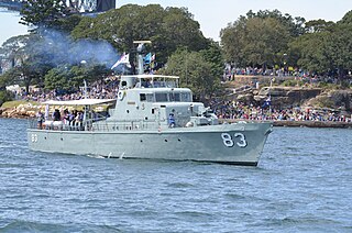
HMAS Advance was an Attack-class patrol boat of the Royal Australian Navy (RAN). Constructed during 1967 and commissioned into the RAN in 1968, Advance operated from Darwin and patrolled northern Australian waters.

Watsons Bay is a harbourside, eastern suburb of Sydney, in the state of New South Wales, Australia. Watsons Bay is located 11 km north-east of the Sydney central business district, in the local government area of the Municipality of Woollahra.

Waverton is a suburb on the lower North Shore of Sydney, New South Wales, Australia. Waverton is 4 kilometres north of the Sydney central business district, in the local government area of North Sydney Council.

HMAS Kuttabul is a Royal Australian Navy (RAN) base located in Potts Point in Sydney, New South Wales, Australia. Kuttabul provides administrative, training, logistics and accommodation support to naval personnel assigned to the various facilities that form Fleet Base East, the main operational navy base on the east coast of Australia. A part of Fleet Base East itself, Kuttabul occupies several buildings in the Sydney suburb of Potts Point and in the immediately adjacent Garden Island dockyard. It also supports navy personnel posted to other locations throughout the greater Sydney region.

The Fleet Base East is a Royal Australian Navy (RAN) major fleet base that comprises several naval establishments and facilities clustered around Sydney Harbour, centred on HMAS Kuttabul. The Fleet Base East extends beyond the borders of Kuttabul and includes the commercially-operated dockyard at Garden Island, and adjacent wharf facilities at nearby Woolloomooloo, east of the Sydney central business district in New South Wales, Australia. Fleet Base East is one of two major facilities of the RAN, the other facility being the Fleet Base West.

HMAS Waterhen is a Royal Australian Navy (RAN) base located in Waverton on Sydney's lower north shore, within Sydney Harbour, in New South Wales, Australia. Constructed on the site of a quarry used to expand Garden Island in the 1930s, the location was used during World War II as a boom net maintenance and storage area. In 1962, the area was commissioned as a base of the RAN, and became home to the RAN's mine warfare forces. Waterhen was the first small-ship base established by the RAN, and from 1969 to 1979 was also responsible for the RAN's patrol boat forces.

Catherine Hill Bay is a coastal bay and village on the southern peninsula forming Lake Macquarie, south of the Pacific Ocean entrance channel at Swansea in New South Wales, Australia. It is part of the City of Lake Macquarie local government area. The village is the oldest continuous settlement in the City of Lake Macquarie. The Aboriginal people in this area, the Awabakal were the first people of this land.

Bradleys Head is a headland protruding from the north shore of Sydney Harbour, within the metropolitan area of Sydney, New South Wales, Australia. It is named after the First Fleet naval officer William Bradley. The original Aboriginal inhabitants belonged to the Borogegal clan of the Eora nation, and was known as Borogegy, Booraghee, Booragy or Burrogy. Also on the headland is an active lighthouse, Bradleys Head Light, constructed in 1905.
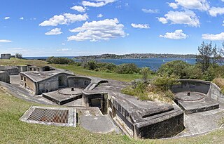
Sydney Harbour was protected by coastal batteries and other fixed defences from the early 19th century until the 1960s. These defences were constructed to protect the Australian city of Sydney from attack by enemy warships and submarines.
HMAS Banks was an Explorer class general-purpose vessel of the Royal Australian Navy (RAN), serving in a range of capacities from 1960 until 1995. She was named in honour of Sir Joseph Banks, the botanist aboard HM Bark Endeavour during the discovery of the eastern coast of Australia in 1770.

HMS Nelson was a 126-gun first rate ship of the line of the Royal Navy, launched on 4 July 1814 at Woolwich Dockyard, but then laid up incomplete at Portsmouth until 1854, when work began with a view to commissioning her for service in the Crimean War, but this ended before much work had been done, and the ship returned to reserve.

HMCSProtector was a large flat-iron gunboat commissioned and purchased by the South Australian government in 1884, for the purpose of defending the local coastline against possible attacks in the aftermath of the 'Russian scare', of the 1870s. She arrived in Adelaide in September 1884 and subsequently served in the Boxer Rebellion, World War I and World War II.

The Historic Shipwrecks Act 1976 was an Australian Act of Parliament designed to legally protect historic shipwrecks and any relics or artefacts from those wrecks. The Act automatically affects all shipwrecks that meet the "historic" criteria and are in Australian Commonwealth waters : complementary state and territory legislation protects shipwrecks in state and territory waters including rivers and bays. Of the estimated 8,000 shipwrecks in Australian waters, more than 6,500 are protected under this legislation.

MV Cape Don is a former lighthouse tender, now a museum ship and training ship in Waverton, New South Wales, Australia.

Shag Bay is an inlet on the River Derwent near Geilston Bay, Tasmania, and is within the East Risdon State Reserve. The area around Shag Bay contains a number of Aboriginal Tasmanian shell middens. A bone meal fertiliser factory was established in Shag Bay in the early 1900s. In January 1915, its boiler exploded, resulting in two deaths of two people associated with the factory. The brigantine built in 1814 HMS Nelson was towed to Shag Bay in 1920 to be broken up after it finished its use as a coal hulk.
Lalla Rookh was a barque of 372 tons built by Edward Allen in St Helier, Jersey, in 1939. Her dimensions were 99.9 x 24.0 x 16.8 ft.
Lalla Rookh was a clipper/brig variously recorded as 184 tons and 147 tons, built in Peterhead, Aberdeenshire, Scotland in 1848. She was described as one of the "new Aberdeen clippers".
Lalla Rookh was an Australian wooden two-masted ketch, also sometimes referred to as a schooner, 59 tons. She was built on the Bellinger River in New South Wales in 1875, and named after Lalla Rookh, the first sizeable ship to visit Brisbane. The ketch Lalla Rookh was first registered in Townsville, Queensland, by Aplin Brown & Company.
References
- ↑ "HMAS Waterhen". HMA Ship Histories. Sea Power Centre, Royal Australian Navy . Retrieved 25 January 2021.
- ↑ "View Shipwreck - Lalla Rookh". Australasian Underwater Cultural Heritage Database . Australian Government. Department of Agriculture, Water and the Environment . Retrieved 25 January 2021. (Creative Commons 4.0 International licence.)
Coastal bays and inlets of New South Wales, Australia | |
|---|---|
| North of Sydney Harbour |
|
| Within Sydney Harbour | |
| South of Sydney Harbour | |
Coordinates: 33°51′S151°12′E / 33.850°S 151.200°E
| | This article related to the geography of Sydney is a stub. You can help Wikipedia by expanding it. |