White Bay (New South Wales)

Last updated

White Bay looking towards the Sydney central business district and Harbour Bridge White Bay New South Wales 1.JPG
White Bay looking towards the Sydney central business district and Harbour Bridge

White Bay is a bay on Sydney Harbour with a surrounding locality near the suburbs of Balmain and Rozelle in the Inner West of Sydney, New South Wales, Australia.

Contents

History

P&O's Pacific Jewel docked at White Bay Wharves in 2009 Pacific Jewell at White Bay.JPG
P&O's Pacific Jewel docked at White Bay Wharves in 2009

White Bay is named after John White, the naval surgeon aboard the First Fleet to Australia in 1788. [1] Since the nineteenth century the bay has been used for water-based transport and industrial activities. In conjunction with adjacent Glebe Island it has been a multipurpose port, owned and controlled by the Government of New South Wales since 1901. [2] [3]

White Bay was the first port in New South Wales to handle containerised shipping, opening in 1969 on reclaimed land. [4] [5] In the 1970s there were several companies operating container terminals, with rail transfer via the Metropolitan Goods line to larger holding yards at Chullora. Container handling moved out of White Bay in late 2004 moving to Port Botany. [6]

The White Bay Cruise Terminal opened in April 2013 replacing a terminal at Wharf 8 on Darling Harbour. [7] White Bay is also used for marine refuelling. [6]

Landmarks

White Bay Hotel 2008 White Bay Hotel.JPG
White Bay Hotel 2008

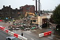
The White Bay Hotel was a historic hotel on Victoria Road. It was built in 1861, rebuilt in 1916, and refurbished in 1925 and 1933. It closed in 1992, landlocked by roads and with no local workers. Until 2004 it served only as a platform for billboards advertising to traffic on the Western Distributor, and on 5 September 2008 was destroyed by a suspicious fire and immediately demolished. [8] [9] The state government bought the site in June 2010. [10] The rubble was removed on 29 October 2010 and the block levelled.

The derelict White Bay Power Station dominates the landscape. On the eastern side stands the Anzac Bridge, which was completed in 1996 and is the main arterial link between the inner west and Sydney city. Below the bridge lies its predecessor, the Glebe Island Bridge, which opened in 1903. [11]

Notable residents

For 25 years from 1971 to just before her death in 1996, one of Sydney's true characters, Beatrice Olive ("Beattie") Bush, sold papers to passing motorists at the junction of The Crescent (City West Link) and Victoria Road. [12] Every morning in all weather, wearing Balmain Tigers socks and running shoes, Beatrice was part of the drive to work for thousands of motorists. [12]

The 1984 song The White Bay Paper Seller by Judy Small was written about Beatrice. The 1986 painting Beatrice the Paper-Seller of the White Bay Intersection by Susan Dorothea White shows Beatrice Bush running between the cars and trucks, selling newspapers in the rain. The 2004 documentary, The Paper Queen by Julie Nebauer documented her life. [13] In 2005 a new cycle bridge crossing Victoria Road at the intersection of The Crescent was named the Beatrice Bush Bridge in her honour. Her newspaper trolley, hat, gloves and other clothing items are held in the Powerhouse Museum collection in Sydney. [12]

Related Research Articles

Port Jackson Body of water in Sydney, Australia

Port Jackson, consisting of the waters of Sydney Harbour, Middle Harbour, North Harbour and the Lane Cove and Parramatta Rivers, is the ria or natural harbour of Sydney, Australia. The harbour is an inlet of the Tasman Sea. It is the location of the Sydney Opera House and Sydney Harbour Bridge. The location of the first European settlement and colony on the Australian mainland, Port Jackson has continued to play a key role in the history and development of Sydney.

Anzac Bridge

The Anzac Bridge is an eight-lane cable-stayed bridge that carries the Western Distributor (A4) across Johnstons Bay between Pyrmont and Glebe Island, on the western fringe of the central business district of Sydney, New South Wales, Australia. The bridge forms part of the road network leading from the central business district, the Sydney Harbour Bridge, and Cross City Tunnel to the Inner West and Northern Suburbs.

Balmain, New South Wales Suburb of Sydney, New South Wales, Australia

Balmain is a suburb in the Inner West of Sydney, New South Wales, Australia. Balmain is located 2 km (1.2 mi) west of the Sydney central business district, in the local government area of the Inner West Council. It sits on a small peninsula that juts out of Sydney Harbour, directly opposite Milsons Point.

Leichhardt, New South Wales Suburb of Sydney, New South Wales, Australia

Leichhardt is a suburb in the Inner West of Sydney, in the state of New South Wales, Australia. Leichhardt is located 5 kilometres west of the Sydney central business district (CBD) and is the administrative centre for the local government area (LGA) of the Inner West Council. The suburb is bordered by Haberfield to the west, Annandale to the east, Lilyfield to the north and Petersham, Lewisham and Stanmore to the south.

Glebe, New South Wales Suburb of Sydney, New South Wales, Australia

Glebe is an inner-western suburb of Sydney. Glebe is located 3 kilometres (1.9 mi) southwest of the Sydney central business district and is part of the local government area of the City of Sydney, in the Inner West region.

Lilyfield, New South Wales Suburb of Sydney, New South Wales, Australia

Lilyfield is a suburb in the Inner West of Sydney, in the state of New South Wales, Australia. Lilyfield is located 6 kilometres west of the Sydney central business district, in the local government area of the Inner West Council.

Pyrmont, New South Wales Suburb of Sydney, New South Wales, Australia

Pyrmont is an inner-city suburb of Sydney, in the state of New South Wales, Australia 2 kilometres south-west of the Sydney central business district in the local government area of the City of Sydney. It is also part of the Darling Harbour region. As of 2011, it is Australia's most densely populated suburb.

Rozelle Suburb of Sydney, New South Wales, Australia

Rozelle is a suburb in the inner west of Sydney, in the state of New South Wales, Australia. It is located 4 kilometres west of the Sydney central business district, in the local government area of the Inner West Council.

Glebe Island Bridge

The Glebe Island Bridge is a heritage-listed disused swing Allan truss road bridge that carried Victoria Road across Rozelle Bay, located in the inner city Sydney suburb of Pyrmont in the City of Sydney local government area of New South Wales, Australia. The bridge, that connected Rozelle to Pyrmont by road, is one of the last remaining swing bridges of its type in Australia and in the world. It was designed by Percy Allan and built from 1899 to 1903 by Bridges Branch of NSW Public Works Department. It is also known as RMS Bridge No. 61. It was added to the New South Wales State Heritage Register on 29 November 2013 and was listed on the Register of the National Estate on 19 April 1989.

Drummoyne, New South Wales Suburb of Sydney, New South Wales, Australia

Drummoyne is a suburb in the Inner West of Sydney, in the state of New South Wales, Australia. Drummoyne is 6 kilometres west of the Sydney central business district and is the administrative centre for the local government area of the City of Canada Bay.

Balmain East, New South Wales Suburb of Sydney, New South Wales, Australia

Balmain East is a suburb in the Inner West of Sydney, in the state of New South Wales, Australia. Balmain East is located three kilometres west of the Sydney central business district, in the local government area of the Municipality of Leichhardt.

Iron Cove Bridge

The Iron Cove Bridge is a heritage-listed road bridge that carries Victoria Road (A40) across Iron Cove, linking the Sydney suburbs of Drummoyne to Rozelle in the City of Canada Bay local government area of New South Wales, Australia.

Sydney Freight Network Railway line in Sydney, New South Wales, Australia

The Sydney Freight Network is a network of dedicated railway lines for freight in Sydney, Australia linking the state's rural and interstate rail network with the city's main yard at Enfield and Port Botany. Its primary components are the Southern Sydney Freight Line (SSFL) and a line from Sefton to Enfield and Port Botany. The Network has been managed by the Australian Rail Track Corporation (ARTC) since 2012. Prior to the completion of the SSFL, it was managed by RailCorp as the Metropolitan Freight Network.

Western Distributor (Sydney)

The Western Distributor is a 3.8-kilometre-long (2.4 mi) grade-separated motorway that is primarily elevated for the majority of its route on the western fringe of the Sydney central business district in New South Wales, Australia. From its northern terminus, it links the southern end of the Bradfield Highway at the Sydney Harbour Bridge to Victoria Road in Rozelle, at its western terminus near White Bay. The freeway is designated as part of the A4 for its entire distance.

Electoral district of Balmain state electoral district of New South Wales, Australia

Balmain is an electoral district of the Legislative Assembly of the Australian state of New South Wales in Sydney's Inner West. It is currently represented by Jamie Parker of the Greens New South Wales.

Johnstons Creek (New South Wales)

Johnstons Creek, formerly Johnston's Creek, is an urban gully, located in Sydney, Australia and situated in the Leichhardt local government area. The creek flows from Petersham, past Annandale, Camperdown, Forest Lodge and Harold Park, before spilling into Rozelle Bay, within Sydney Harbour.

White Bay Hotel

The White Bay Hotel is a former pub in operation between 1860 and 1992, since destroyed by fire, demolished, and the land acquired by the New South Wales Government.

Beach Hotel, Rozelle

The Beach Hotel is an historic de-licensed pub in the suburb of Rozelle, above White Bay in the Inner West of Sydney, New South Wales, Australia. It is currently a private residence after having been in a long state of abandonment.

Glebe Island

Glebe Island was a major port facility in Sydney Harbour and, in association with the adjacent White Bay facility, was the primary receiving venue for imported cars and dry bulk goods in the region until 2008. It is surrounded by White, Johnstons, and Rozelle Bays. Whilst retaining its original title as an "island", it has long been infilled to the shoreline of the suburb of Rozelle and connected by the Glebe Island Bridge to Pyrmont.

The Bays Precinct is a proposed urban renewal project in Sydney, Australia. It will involve the redevelopment of 95 hectares of land adjoining Sydney Harbour formerly used by industry. Among the sites to be redeveloped are the Rozelle railway yards, White Bay Power Station, Glebe Island port, the Sydney Fish Market and Wentworth Park.

References

  1. "White Bay". Geographical Names Register (GNR) of NSW. Geographical Names Board of New South Wales . Retrieved 12 October 2013. OOjs UI icon edit-ltr-progressive.svg
  2. Glebe Island and White Bay Master Plan, Part A Sydney Ports 2000
  3. Glebe Island and White Bay Master Plan, Part B Sydney Ports 2000
  4. Container Terminal Ready at Sydney's White Bay Network February 1969 page 2
  5. First stage of White Bay container terminal finished Freight & Container Transportation February 1969 page 11
  6. 1 2 "Tall Ships to Cruise Ships - White Bay History 1854 to Present" (PDF). Sydney Ports Corporation. 11 April 2013. Retrieved 6 January 2017.
  7. White Bay Cruise Terminal Port Authority of New South Wales
  8. Last drinks at Rozelle's historic White Bay Hotel Sydney Morning Herald 6 September 2008
  9. White Bay Hotel Fire at Rozelle Fire and Rescue NSW 6 September 2008
  10. State snaps up White Bay Hotel site Sydney Morning Herald 30 June 2010
  11. Anzac Bridge Office of Environment & Heritage
  12. 1 2 3 Powerhouse Museum; Statement of significance: Newspaper trolley owner by Beatrice Bush; ; Retrieved on 5 November 2006.
  13. Australian Film Commission; The Paper Queen; Film Database Entry; ; Retrieved on 5 November 2006.

Coordinates: 33°51′50″S151°11′02″E / 33.864°S 151.184°E / -33.864; 151.184