The Royal National Park is a protected national park that is located in Sutherland Shire local government area in the southern portion of Sydney, New South Wales, Australia.

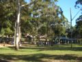
Bundeena is a village and suburb on the outskirts of southern Sydney, in the state of New South Wales, Australia. Bundeena is located 29 kilometres south of the Sydney central business district and is part of the local government area of the Sutherland Shire.

Caringbah is a suburb in Southern Sydney, in the state of New South Wales, Australia. Caringbah is 24 kilometres (15 mi) south of the Sydney central business district in the local government area of Sutherland Shire.

Sutherland Shire is a local government area in the southern region of Sydney, in the state of New South Wales, Australia. The Sutherland Shire is located just south of the Sydney CBD, and comprises an area of 370 square kilometres (140 sq mi) and as at the 2016 census and has an estimated population of 218,464. The Sutherland Shire is colloquially known as "The Shire" which has been featured in several reality television series.

Cronulla is a suburb of Sydney, in the state of New South Wales, Australia. Boasting numerous surf beaches and swimming spots, the suburb attracts both tourists and Greater Sydney residents. Cronulla is 26 kilometres south of the Sydney central business district, in the local government area of the Sutherland Shire.

Woolooware is a suburb in southern Sydney, in the state of New South Wales, Australia. Woolooware is located 24 kilometres (15 mi) south of the Sydney central business district in the Sutherland Shire. It shares the 2230 postcode with Cronulla.

Port Hacking is a small bayside suburb located on the north shore of the Port Hacking estuary in southern Sydney, in the state of New South Wales, Australia. The suburb is situated 26.7 kilometres south of the Sydney central business district in the local government area of the Sutherland Shire.
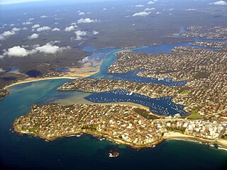
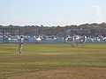
Port Hacking Estuary, an open youthful tide dominated, drowned valley estuary, is located in southern Sydney, New South Wales, Australia approximately 30 kilometres (19 mi) south of Sydney central business district. Port Hacking has its source in the upper reaches of the Hacking River south of Helensburgh, and several smaller creeks, including South West Arm, Bundeena Creek and The Basin and flows generally to the east before reaching its mouth, the Tasman Sea, south of Cronulla and north–east of Bundeena. Its tidal effect is terminated at the weir at Audley, in the Royal National Park. The lower estuary features a substantial marine delta, which over time has prograded upstream. There is also a substantial fluvial of the Hacking River at Grays Point. The two deltas are separated by a deep basin.

Maianbar is a village on the outskirts of southern Sydney, in the state of New South Wales, Australia 29 kilometres south of the Sydney central business district. It is part of the Sutherland Shire.
Lilli Pilli is a small suburb in southern Sydney, in the state of New South Wales, Australia. Lilli Pilli is located 26 kilometres south of the Sydney central business district, in the local government area of the Sutherland Shire.

Burraneer is a bayside suburb in southern Sydney, in the state of New South Wales, Australia. Burraneer is 26 kilometres south of the Sydney central business district, in the local government area of the Sutherland Shire.

The locality and suburb of Gymea Bay are located in southern Sydney, in the state of New South Wales, Australia. Gymea Bay is 27 kilometres (17 mi) south of the Sydney central business district, in the local government area of the Sutherland Shire. The postcode is 2227, which it shares with the adjacent suburb of Gymea. The Gymea Bay locality takes its name from the adjoining Gymea Bay, a small bay on the north side of the Port Hacking estuary).

Dolans Bay is a bayside suburb in Southern Sydney, in the state of New South Wales, Australia, that is located 26 kilometres (16 mi) south of the Sydney central business district, in the local government area of the Sutherland Shire.

The Dolans Bay is a cove on the Burraneer Bay adjacent to the lower estuarine Hacking River of Port Hacking in southern Sydney, in the state of New South Wales, Australia.

The geography of Sydney is characterised by its coastal location on a basin bordered by the Pacific Ocean to the east, the Blue Mountains to the west, the Hawkesbury River to the north and the Woronora Plateau to the south. Sydney lies on a submergent coastline on the east coast of New South Wales, where the ocean level has risen to flood deep river valleys (rias) carved in the Sydney sandstone. Port Jackson, better known as Sydney Harbour, is one such ria.
Cronulla and National Park Ferry Cruises is a ferry operator on Port Hacking in Southern Sydney Australia.
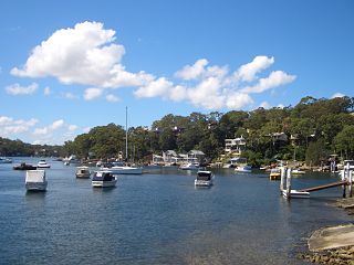
The Burraneer Bay is a bay on the lower estuarine Hacking River of Port Hacking in southern Sydney, in the state of New South Wales, Australia.

The Woolooware Bay is a bay on the lower estuarine Georges River in southern Sydney, in the state of New South Wales, Australia.

The Cronulla Fisheries Centre or Cronulla Fisheries Research Centre is a heritage-listed former fisheries research centre and now public reserve and marine rescue base located at the Southern end of Nicholson Parade, Cronulla, Sydney, New South Wales, Australia. It was built from 1904. It is also known as The Cronulla Fisheries Centre and Hungry Point Reserve; NSW Fisheries Research Institute; CSIRO Fisheries Division and the CSIRO Division of Fisheries & Oceanography. The property is owned by the NSW Department of Primary Industries, a department of the Government of New South Wales. The site has heritage listed buildings and several Australian Aboriginal sites. It was added to the New South Wales State Heritage Register on 2 April 1999.