Wanda Beach

Last updated

Wanda Beach
Beach
Wanda Beach 1.JPG
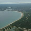
View of Wanda Beach looking east towards Bate Bay
Coordinates: 34°02′36″S151°09′43″E / 34.04333°S 151.16194°E / -34.04333; 151.16194
Location Cronulla, Sydney, New South Wales, Australia
Dimensions
  Length1500 m
Patrolled by Wanda Surf Life Saving Club
Hazard rating7/10 (highly hazardous)
  Greenhills
Elouera  
Designations
Official nameCronulla Sand Dune and Wanda Beach Coastal Landscape
TypeLandscape – Natural
Criteriaa, b, c, d, e, f, g
Designated26 September 2003
Reference no.01668

Wanda Beach or Wanda is the northernmost patrolled beach at Bate Bay in Cronulla, Sydney, New South Wales, New South Wales, Australia. [1] Green Hills or Green Hills Ridge is the name given to the Cronulla sand dunes, just north of Wanda. [2]

Contents

History

The original inhabitants of the land were the Gweagal Aborigines who were a clan of the Tharawal (or Dharawal) tribe of Indigenous Australians. They are the traditional custodians of the southern geographic areas of Sydney. Wanda is an Aboriginal word for beach or sand hills. [3]

The Wanda Surf Lifesaving Club [4] was established in 1946 after World War II by a group of men who banded together, as they did in warfare, to patrol the beaches. The colours of Army red, Air Force blue, and Navy blue were adopted as the club colours. The club, located on Marine Esplanade, has grown in size to its current membership of over 900 male and female members, ranging in age from five-year-old Nippers to the original Founding Members. The primary objective of the club is to patrol the beach in an effort to ensure the safety of the surfing public but it is also actively involved in the competition arena, with excellent performances at State and National Competitions. A number of social activities are organised throughout the year to bring together members from all sections of the club.

In 1965 the beach became notorious after the Wanda Beach Murders.

Related Research Articles

<span class="mw-page-title-main">Surf lifesaving</span> Beach surf lifesaving volunteers

Surf lifesaving is a multifaceted social movement that comprises key aspects of voluntary lifeguard services and competitive surf sport. Originating in early 20th century Australia, the movement has expanded globally to other countries, including New Zealand, Ireland, South Africa, and the United Kingdom. Surf lifesavers in Australia are colloquially known as "Clubbies".

<span class="mw-page-title-main">Cronulla, New South Wales</span> Suburb of Sydney, New South Wales, Australia

Cronulla is a suburb of Sydney, in the state of New South Wales, Australia. Boasting numerous surf beaches and swimming spots, the suburb attracts both tourists and Greater Sydney residents. Cronulla is located 26 kilometres south of the Sydney central business district, in the local government area of the Sutherland Shire.

Sawtell is a suburb of the City of Coffs Harbour in northern New South Wales, Australia. It borders Toormina to the West.

<span class="mw-page-title-main">Mollymook</span> Town in New South Wales, Australia

Mollymook is a town located on the South Coast of New South Wales, Australia approximately three hours' drive south of Sydney within the City of Shoalhaven local government area. At the 2016 census, Mollymook had a population of 1,083 while the adjacent locality of Mollymook Beach was home to a further 2,447 people. Geographically, Mollymook is considered part of the Milton-Ulladulla district, a coastal corridor of urban development stretching from Burrill Lake, south of Ulladulla to Mollymook's northern neighbour, Narrawallee and the historic town of Milton a few kilometres inland.

<span class="mw-page-title-main">North Curl Curl, New South Wales</span> Suburb of Sydney, New South Wales, Australia

North Curl Curl is a suburb in northern Sydney, in the state of New South Wales, Australia 19 kilometres north-east of the Sydney central business district, in the local government area of Northern Beaches Council. It is part of the Northern Beaches region.

<span class="mw-page-title-main">Tamarama</span> Suburb of Sydney, New South Wales, Australia

Tamarama is a beachside suburb, eastern suburb of Sydney, in the state of New South Wales, Australia. Tamarama is 6 kilometres east of the Sydney central business district, in the local government area of Waverley Council.

<span class="mw-page-title-main">Nippers</span>

Nippers are young surf lifesavers, usually aged between 5 and 14 years old, in clubs across Australia, New Zealand and South Africa. Unlike senior surf lifesavers, the majority of them do not patrol the beaches. The focus for Nippers tends to be on fun, and surf awareness.

<span class="mw-page-title-main">Cronulla Beach</span>

Cronulla Beach, is a patrolled beach on Bate Bay in the Sydney suburb of Cronulla, New South Wales, Australia. The Cronulla Pavilion and the Cronulla Lifesaving Club are two prominent buildings located close to the sand. Cronulla Park sits behind the beach. The Cronulla Rock Pools are between Cronulla Beach and North Cronulla beach. The Alley is the local name given to the area between Cronulla Beach and North Cronulla Beach. Shark Island is a dangerous reef break, located off Cronulla Beach.

<span class="mw-page-title-main">Forster, New South Wales</span> Town in New South Wales, Australia

Forster is a coastal town in the Mid North Coast region of New South Wales, Australia, in the Mid-Coast Council LGA, about 308 km north-north-east of Sydney. It is immediately adjacent to its twin, Tuncurry, which is the smaller of the two towns. Forster is known for its stunning waters and Manning Valley beauty.

<span class="mw-page-title-main">Elouera Beach</span>

Elouera Beach or Elouera is a patrolled beach on Bate Bay, in Cronulla, Sydney, New South Wales, Australia. The Wall is the local name given to the area between North Cronulla Beach and Elouera.

<span class="mw-page-title-main">North Cronulla Beach</span> Beach in New South Wales, Australia

North Cronulla Beach or North Cronulla is a patrolled beach on Bate Bay, in Cronulla, Sydney New South Wales, Australia. The Wall is the local name given to the area between North Cronulla Beach and Elouera. The Alley is the local name given to the permanent rip current located at the southern end of North Cronulla Beach.

<span class="mw-page-title-main">Jones Beach (New South Wales)</span>

Jones Beach, also known as Boyds Beach, is a beach on the south-eastern coast of Australia, facing the Tasman Sea. The beach is east of the settlement of Kiama Downs and about 2 kilometres (1.2 mi) south by east of the settlement of Minnamurra in the Illawarra and South Coast regions of New South Wales.

<span class="mw-page-title-main">Cronulla sand dunes</span> Sand dunes in Sydney, New South Wales, Australia

The Cronulla sand dunes, also known officially as the Cronulla Sand Dune and Wanda Beach Coastal Landscape, are an open space, heritage-listed nature conservation, and visitor attraction located on the Kurnell Peninsula at Lindum Road, Kurnell within the Sutherland Shire local government area of Sydney, New South Wales, Australia. Formerly, it was a site for sand mining, film making, and had use as pastoral property. It is also known as part of Kurnell Peninsula Headland and Cronulla Sand Hill. It was added to the New South Wales State Heritage Register on 26 September 2003.

<span class="mw-page-title-main">Scotts Head, New South Wales</span> Suburb of Nambucca Valley Council, New South Wales, Australia

Scotts Head is a coastal village of the Nambucca Valley local government area in the Mid North Coast region of New South Wales, Australia. Located on the coast of the Pacific Ocean, approximately 10 kilometres (6 mi) from the Pacific Highway and 480 kilometres (300 mi) from Sydney, it stretches southwards from just south of the mouth of the Nambucca River to the town of Scotts Head in the south.

The club was founded in 1903 and the movement has since spread to other parts of New South Wales and the rest of the country. The club rests on indigenous land and whilst there is no clear evidence for the name or names of the Eora people who lived in what is now the Waverley area, most sources agree on the Cadigal, but some sources name the Biddigal and Birrabirragal bands as well.

Redhead Surf Lifesaving Club is one of the oldest surf clubs on the New South Wales coast. Founded in 1908, it is located on Redhead Beach, in the suburb of Redhead about 15 kilometres (9.3 mi) south of Newcastle. It is affiliated with Surf Life Saving Australia, and its club colours are yellow and blue.

The Palm Beach Surf Life Saving Club is an Australian Surf Life Saving Club. The Club offers a range of activities and encourages members to continually develop and update their lifesaving skills. It is located at the southern end of Palm Beach, New South Wales, and members provide voluntary patrols on weekends and public holidays. Its members participate in internal and external competitions. Palm Beach Surf Life Saving Club is a voluntary, non-for-profit organisation. It is considered that "if you have on your resume that you're a member of Palm Beach Surf Club, you've really made Sydney's social set."

<span class="mw-page-title-main">Cronulla Surf Life Saving Club</span>

The Cronulla Surf Life Saving Club, was one of the first surf clubs established in Australia in 1907. The club is located in the southern Sydney suburb of Cronulla, which had very humble beginnings in a tram carriage and today the clubhouse is housed in a magnificent art deco building on the beachfront, that was built in 1940.

<span class="mw-page-title-main">Greenhills Beach</span>

Greenhills Beach is an unpatrolled beach on Bate Bay, located in Greenhills Beach, Sydney, New South Wales, Australia. The beach is located roughly 18 kilometres from the Sydney central business district, in the local government area of the Sutherland Shire. Recognised as one of Sydney's longest beaches, Greenhills beach is roughly 3 kilometres in length and forms part of a chain of beaches residing on Bate Bay. It is the northernmost section of the Greenhills-North Cronulla beach complex and is the only section of the beach not to be patrolled by a Surf Club or by volunteer lifesavers.

The Wanda Surf Lifesaving Club was established in 1946 after World War II by a group of men who banded together, from the North Cronulla Surf Life Saving Club who were being asked to patrol this stretch of beach, being a considerable distance from the Cronulla area. The colours of Army red, Air Force blue, and Navy blue were adopted as the club colours. The club, located on Marine Esplanade, has grown in size to its current membership of over 900 male and female members, ranging in age from five-year-old Nippers to the original Founding Members.

References

  1. "Wanda Beach". Geographical Names Register (GNR) of NSW. Geographical Names Board of New South Wales . Retrieved 23 June 2007. OOjs UI icon edit-ltr-progressive.svg
  2. "Green Hills". Geographical Names Register (GNR) of NSW. Geographical Names Board of New South Wales . Retrieved 23 June 2007. OOjs UI icon edit-ltr-progressive.svg
  3. "Sutherland Shire Place Names Fact Sheet" (PDF). Retrieved 23 June 2007.
  4. "Wanda Surf Lifesaving Club". Archived from the original on 14 June 2007. Retrieved 23 June 2007.