Greenhills Beach

Last updated

Greenhills Beach
Beach
Green Hills Cronulla.JPG
View across Greenhills Beach facing north
Coordinates: 34°02′18″S151°10′11″E / 34.03833°S 151.16972°E / -34.03833; 151.16972
Location Greenhills Beach, Sydney, New South Wales, Australia
Dimensions
  Length3000 m
Hazard rating3/10 (least hazardous)
  Wanda

Greenhills Beach is an unpatrolled beach on Bate Bay, located in Greenhills Beach, Sydney, New South Wales, Australia. The beach is located roughly 18 kilometres from the Sydney central business district, in the local government area of the Sutherland Shire. Recognised as one of Sydney's longest beaches, Greenhills beach is roughly 3 kilometres in length and forms part of a chain of beaches residing on Bate Bay. It is the northernmost section of the Greenhills-North Cronulla beach complex and is the only section of the beach not to be patrolled by a Surf Club or by volunteer lifesavers.

Contents

History

The beach's name, Greenhills, originates from the Cronulla sand dunes. These dunes, prior to European settlement were abundant with vegetation. However, within a century of European settlement, most of the original vegetation had been cleared, exposing the sand dunes. Many patches of tall grass and shrubs still remain on the dunes, giving a green-colored tint to the hills, thus its naming.

Overview

Greenhills Beach is the northernmost and longest section of a 4-beach complex known as Greenhills-North Cronulla, which also includes Wanda Beach, Elouera Beach and North Cronulla Beach. Greenhills, due to its small notoriety and lack of crowds compared to its southern neighbors, is often cited as a destination for beach-goers in Sydney and for tourists. [1] The beach is also one of few beaches in Sydney to allow dogs to roam the beach, with dogs being allowed off-leash between 4pm and 10am. After community lobbying, the Sutherland Shire Council allowed dogs to roam the beach 24 hours a day following a decision in August 2013. [2] Following two serious dog attacks on the beach, however, the new regulations were repealed after only three weeks, with the council voting to scrap the 24-hour off-leash dogs idea altogether in November 2013. [3]

Merries Reef

A small reef system known as Merries Reef is located at 34°02′47″S151°11′34″E / 34.04639°S 151.19278°E / -34.04639; 151.19278 , at the northernmost part of the beach, off the coastal rocks near Boat Harbour. The reef, which, since 2001, has been protected by the New South Wales Department of Primary Industries as part of the Boat Harbour Aquatic Reserve, is characterised as a popular spearfishing and marine collection area. The reef is home to various lobsters, such as southern rock lobsters and blacklip abalones. [4] [5] Geographically, the reef also serves as a wave break, contributing to the low surf at Greenhills Beach.

See also

Related Research Articles

<span class="mw-page-title-main">Miranda, New South Wales</span> Suburb of Sydney, New South Wales, Australia

Miranda is a suburb in southern Sydney, in the state of New South Wales, Australia. The suburb is known as a commercial centre for the southern suburbs. Miranda is 24 kilometres south of the Sydney central business district, in the Sutherland Shire.

<span class="mw-page-title-main">Caringbah</span> Suburb of Sydney, New South Wales, Australia

Caringbah is a suburb in Southern Sydney, in the state of New South Wales, Australia. Caringbah is 24 kilometres (15 mi) south of the Sydney central business district in the local government area of Sutherland Shire.

<span class="mw-page-title-main">Sutherland, New South Wales</span> City in New South Wales, Australia

Sutherland is a city in southern Sydney, in the state of New South Wales, Australia. Sutherland is located 26 kilometres south of the Sydney central business district and is the administrative centre for the local government area of the Sutherland Shire.

<span class="mw-page-title-main">Eastern Suburbs & Illawarra Line</span> Rail service in Sydney, New South Wales,Australia

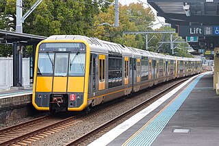
The Eastern Suburbs & Illawarra Line is a commuter railway line on the Sydney Trains network in the eastern and southern suburbs of Sydney. The line was constructed in the 1880s to Wollongong to take advantage of agricultural and mining potentials in the Illawarra area. In March 1926, it became the first railway in New South Wales to run electric train services.

<span class="mw-page-title-main">Sutherland Shire</span> Local government area in New South Wales, Australia

Sutherland Shire is a local government area in the southern region of Sydney, in the state of New South Wales, Australia. The Sutherland Shire is located just south of the Sydney CBD, and comprises an area of 370 square kilometres (140 sq mi) and as at the 2016 census and has an estimated population of 218,464. The Sutherland Shire is colloquially known as "The Shire" which has been featured in several reality television series.

<span class="mw-page-title-main">Cronulla, New South Wales</span> Suburb of Sydney, New South Wales, Australia

Cronulla is a suburb of Sydney, in the state of New South Wales, Australia. Boasting numerous surf beaches and swimming spots, the suburb attracts both tourists and Greater Sydney residents. Cronulla is 26 kilometres south of the Sydney central business district, in the local government area of the Sutherland Shire.

<span class="mw-page-title-main">Towra Point Nature Reserve</span> Protected area in New South Wales, Australia

The Towra Point Nature Reserve is a protected nature reserve that is located in Sutherland Shire, Southern Sydney, New South Wales, in eastern Australia. The 603-hectare (1,490-acre) reserve is situated on the southern shores of Botany Bay at Kurnell, within the Sutherland Shire. The reserve is protected under the Ramsar Convention as a wetland of international importance as an important breeding ground for many vulnerable, protected, or endangered species. The Towra Point Aquatic Nature Reserve is located in the surrounding waterways.

<span class="mw-page-title-main">Maianbar</span> Suburb of Sydney, New South Wales, Australia

Maianbar is a village on the outskirts of southern Sydney, in the state of New South Wales, Australia 29 kilometres south of the Sydney central business district. It is part of the Sutherland Shire.

<span class="mw-page-title-main">Kurnell, New South Wales</span> Suburb of Sydney, New South Wales, Australia

Kurnell is a suburb in Sydney, in the state of New South Wales, Australia. It is 21.4 kilometres (13.3 mi) south of the Sydney central business district, in the local government area of the Sutherland Shire along the east coast. Cronulla and Woolooware are the only adjacent suburbs. La Perouse is located opposite, on the northern headland of Botany Bay. The Cronulla sand dunes are on the south eastern headland of Botany Bay. The eastern side of the peninsula is part of Botany Bay National Park, and Towra Point Nature Reserve is located on the western side of the suburb.

<span class="mw-page-title-main">Cronulla Beach</span>

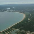
Cronulla Beach, is a patrolled beach on Bate Bay in the Sydney suburb of Cronulla, New South Wales, Australia. The Cronulla Pavilion and the Cronulla Lifesaving Club are two prominent buildings located close to the sand. Cronulla Park sits behind the beach. The Cronulla Rock Pools are between Cronulla Beach and North Cronulla beach. The Alley is the local name given to the area between Cronulla Beach and North Cronulla Beach. Shark Island is a dangerous reef break, located off Cronulla Beach.

<span class="mw-page-title-main">Wanda Beach</span>

Wanda Beach or Wanda is the northernmost patrolled beach at Bate Bay in Cronulla, Sydney, New South Wales, Australia. Green Hills or Green Hills Ridge is the name given to the Cronulla sand dunes, just north of Wanda.

<span class="mw-page-title-main">Shelly Beach (Cronulla)</span>

Shelly Beach is a beach on Bate Bay in Cronulla, Sydney, New South Wales, Australia. Shelly Park sits behind the beach. Shelly Pavilion is located between the beach and the park.

<span class="mw-page-title-main">Elouera Beach</span>

Elouera Beach or Elouera is a patrolled beach on Bate Bay, in Cronulla, Sydney, New South Wales, Australia. The Wall is the local name given to the area between North Cronulla Beach and Elouera.

<span class="mw-page-title-main">North Cronulla Beach</span> Beach in New South Wales, Australia

North Cronulla Beach or North Cronulla is a patrolled beach on Bate Bay, in Cronulla, Sydney New South Wales, Australia. The Wall is the local name given to the area between North Cronulla Beach and Elouera. The Alley is the local name given to the permanent rip current located at the southern end of North Cronulla Beach.

<span class="mw-page-title-main">Cronulla sand dunes</span> Sand dunes in Sydney, New South Wales, Australia

The Cronulla sand dunes, also known officially as the Cronulla Sand Dune and Wanda Beach Coastal Landscape, are an open space, heritage-listed nature conservation, and visitor attraction located on the Kurnell Peninsula at Lindum Road, Kurnell within the Sutherland Shire local government area of Sydney, New South Wales, Australia. Formerly, it was a site for sand mining, film making, and had use as pastoral property. It is also known as part of Kurnell Peninsula Headland and Cronulla Sand Hill. It was added to the New South Wales State Heritage Register on 26 September 2003.

<span class="mw-page-title-main">Great Mackerel Beach</span> Suburb of Sydney, New South Wales, Australia

Great Mackerel Beach is a suburb about 43 kilometres north of the Sydney central business district, from 2016 in the local government area of Northern Beaches Council, Sydney, New South Wales, Australia, formerly part of Pittwater Council. It is on the western shores of Pittwater in Ku-ring-gai Chase National Park, beside Currawong Beach, and near Coasters Retreat and Palm Beach.The resident population was 50 at the 2021 census; the median age was 57, with an average of 0.3 children per family and an average of 1.7 people per household. The population was 36 at the 2016 census, 301 at the 2011 census, and 103 in 2006. As of 2021 there were 111 private dwellings, with many people not listed as residents occupying properties during school holidays and weekends. Great Mackerel Beach is frequently referred to as Mackerel Beach or [Great] Mackeral Beach, although the spelling "Mackerel" is becoming standard.

<span class="mw-page-title-main">Boat Harbour (Kurnell)</span>

Boat Harbour is a small beach located on the southern side of the Botany Bay National Park in Kurnell, Sydney, New South Wales, Australia.

<span class="mw-page-title-main">Greenhills Beach, New South Wales</span> Suburb of Sydney, New South Wales, Australia

Greenhills Beach is a beachside suburb, in southern Sydney, in the state of New South Wales, Australia in the local government area of Sutherland Shire. Nearby are countless bike tracks, Cronulla Sand Dunes, Greenhills Beach and Wanda Park.
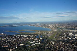
<span class="mw-page-title-main">Cronulla Fisheries Centre</span> Historic site in New South Wales, Australia

The Cronulla Fisheries Centre or Cronulla Fisheries Research Centre is a heritage-listed former fisheries research centre and now public reserve and marine rescue base located at the Southern end of Nicholson Parade, Cronulla, Sydney, New South Wales, Australia. It was built from 1904. It is also known as The Cronulla Fisheries Centre and Hungry Point Reserve; NSW Fisheries Research Institute; CSIRO Fisheries Division and the CSIRO Division of Fisheries & Oceanography. The property is owned by the NSW Department of Primary Industries, a department of the Government of New South Wales. The site has heritage listed buildings and several Australian Aboriginal sites. It was added to the New South Wales State Heritage Register on 2 April 1999.

References

  1. Flynn, Georgia E. (29 July 2010). "Greenhills Beach". Weekend Notes. On Topic Media. Archived from the original on 21 January 2015. Retrieved 21 January 2015.
  2. Mitchell, Georgina (15 August 2013). "Dogs allowed off leash cause waves at beach". The Sydney Morning Herald . Archived from the original on 7 January 2015. Retrieved 21 January 2015.
  3. Gainsford, Jim (26 November 2013). "Doggone it: 24-hour dog off-leash area at Wanda beach cancelled". St George and Sutherland Shire Leader . Archived from the original on 2 July 2022. Retrieved 21 January 2015.
  4. "Boat Harbour Aquatic Reserve". New South Wales Department of Primary Industries . Government of New South Wales. Archived from the original on 21 January 2015. Retrieved 21 January 2015.
  5. NSW DPI (20 June 2014). "Boat Harbour Aquatic Reserve - Boat-Harbour_web.PDF" (PDF). New South Wales Department of Primary Industries . Government of New South Wales. Archived (PDF) from the original on 2 July 2022. Retrieved 21 January 2015.