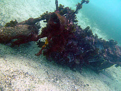
Shelly Beach (Manly)

Last updated

Shelly Beach, Manly Shelly Beach Manly.JPG
Shelly Beach, Manly
Beautiful protected beach perfect for snorkeling and swimming Shelly Beach in Summer 2022.jpg
Beautiful protected beach perfect for snorkeling and swimming
Shelly Beach location map Map Shelly Beach.jpg
Shelly Beach location map
The now repaired Sea Nymphs sculpture at Fairy Bower Pool Sea Nymphs Sculpture with Fairy Bower Pool.jpg
The now repaired Sea Nymphs sculpture at Fairy Bower Pool
Motorbike 'wreck' at Shelly MotorbikeShelly.jpg
Motorbike 'wreck' at Shelly

Shelly Beach (also known as Shelley Beach) [1] is a beach located in Manly, a suburb of Sydney, New South Wales, Australia. It is adjacent to North Head and Fairy Bower. Shelly Beach is a western facing beach on the eastern coast of Australia.

Contents

Shelly Beach is part of the no take Cabbage Tree Bay Aquatic Reserve.

History

There is evidence of occupation of Aboriginal people in the area; in particular a shell midden has been recorded near the Fairy Bower car park. This is the reason for its name even though the beach itself is not that shelly. One hundred years ago Shelly Beach was a haven for boat owners, Providing protection from winds and seas from the south. What's also changed is the hillside, which in the early 1920s was home to only several buildings but is now covered with expensive homes from which their occupants can take advantage of the expansive views to the north. [2] There is an old motorbike standing on the seabed in the middle of the bay in around 8m of water.

On the weekend of June 4 & 5, 2016 a severe storm caused extensive damage to the walkway between Manly Beach and Shelly Beach. This included considerable damage to the pathway - with large slabs of concrete being lifted and displaced, the complete disappearance of a small toilet block, damage to an iconic sculpture at Fairy Bower pool and large sections of the safety railing being destroyed. [3] Due to safety concerns, a large barrier and warning signs were installed to discourage people from walking along the path until repairs were made. Despite this, many people ignored the warnings and simply climbed around the rocks to get back to the path. [4] The barriers were removed in August 2016, following the completion of remediation work.

Geography

Shelly Beach pano.jpg
Panoramic view on a crowded summer day, from near the south end of Manly Beach

Shelly Beach is protected from the ocean swell by the reef that lies on the right hand side of the beach (when facing the ocean) and faces west. [5] Cabbage Tree Bay is a small north-facing embayment that includes two small beaches. Shelly Beach is a reflective beach about 100 metres long. Shelly Beach is a protected marine reserve since it is part of Cabbage Tree Bay.

The visibility is good and a large variety of marine life can be seen there. [6] It is excellent for scuba divers, and also for snorkelers [7] as Shelly beach does not get very deep, its maximum depth being about 12 metres. Many areas are shallow with depths ranging from 2 to 6 metres. [8] [9] This particularity makes it popular for casual and regular snorkelers.[ citation needed ] Cabbage Tree Bay was declared a 'No Take' Aquatic Reserve on 31 March 2002. [10]

On the western point of the beach is a surf break known as "Bower" which offers one of the most shallow breaking waves in Sydney. Further along from Bower are Winki and Deadman's, two other well-known breaks which are popular with surfers, especially on south-east, and east swells. [11] Shelly Beach is also one of only a handful of west-facing ocean beaches on the east coast of Australia.

Infrastructure

Facilities include 2 free electric barbecues, showers, toilets and a kiosk selling meals, drinks and coffee. There is a restaurant on the beach called The Boathouse Shelly Beach. [12] There is a bush track around the headland with views of the Northern Beaches and North Head. The facilities also include parking at the rate of $8.00 an hour. Many scuba diving centres take students because it offers excellent conditions for an environment in which to learn SCUBA. [13] [14]

Fame

In the opening scene of the 1983 film BMX Bandits, two characters ride their bicycles down the walkway between Manly Beach and Shelly Beach.

The opening scene of BMX Bandits, featuring Shelly Beach Shelly Beach in BMX Bandits.png
The opening scene of BMX Bandits, featuring Shelly Beach

See also

Related Research Articles

<span class="mw-page-title-main">Snorkeling</span> Swimming while breathing through a snorkel

Snorkeling is the practice of swimming on or through a body of water while equipped with a diving mask, a shaped breathing tube called a snorkel, and usually swimfins. In cooler waters, a wetsuit may also be worn. The use of this equipment allows the snorkeler to observe underwater attractions for extended periods with relatively little effort and to breathe while face-down at the surface.

<span class="mw-page-title-main">Palm Beach, New South Wales</span> Suburb of Sydney, New South Wales, Australia

Palm Beach is a suburb in the Northern Beaches region of Sydney, in the state of New South Wales, Australia. Palm Beach is located 41 kilometres (25 mi) north of the Sydney central business district, in the local government area of Northern Beaches Council. Palm Beach sits on a peninsula at the end of Barrenjoey Road near Pittwater and is the northernmost beach in the Greater Sydney Metropolitan area. The population of Palm Beach was 1,593 as at the 2016 census.

<span class="mw-page-title-main">Manly Beach</span>

Manly Beach is a beach situated among the Northern Beaches of Sydney, Australia, in Manly, New South Wales. From north to south, the three main sections are Queenscliff, North Steyne, and South Steyne.

<span class="mw-page-title-main">Manly, New South Wales</span> Suburb of Sydney, New South Wales, Australia

Manly is a beach-side suburb of northern Sydney, in the state of New South Wales, Australia. It is 17 kilometres (11 mi) north-east of the Sydney central business district and is currently one of the three administrative centres of the local government area of Northern Beaches Council. Manly has a long-standing reputation as a tourist destination, owing to its attractive setting on the Pacific Ocean and easy accessibility by ferry.

<span class="mw-page-title-main">Fairlight, New South Wales</span> Suburb of Sydney, New South Wales, Australia

Fairlight is a suburb of northern Sydney, in the state of New South Wales, Australia. Fairlight is located 13 kilometres north-east of the Sydney central business district in the local government area of Northern Beaches Council and is part of the Northern Beaches region.

<span class="mw-page-title-main">Fairy Bower Beach</span>

Fairy Bower is a beach in the Manly area of Sydney, New South Wales, Australia.

Tumon Bay is a bay in the United States territory of Guam, opening to the Philippine Sea. It is bounded to the north by Two Lovers Point and to the south by Ypao Point. The entirety of the bay falls within the Tumon Bay Marine Preserve, also known as the Tumon Bay Marine Preserve Area (MPA) and Tumon Preserve, one of five marine preserves on Guam. The Preserve measures 4.54 square kilometers and is roughly two miles long. The platform of the fringing reef that separates the open ocean from the lagoon is up to 1,450 feet (440 m) wide. and up to one mile from the shore. The bay is located off of the Tumon area, the tourist center of the island, in the village of Tamuning. The bay is extensively utilized for recreation and fishing.

<span class="mw-page-title-main">Sodwana Bay</span> Bay of the Indian Ocean on the northern KwaZulu-Natal coast of South Africa

Sodwana Bay is a bay in South Africa on the KwaZulu Natal north coast, between St. Lucia and Lake Sibhayi. It is in the Sodwana Bay National Park, and the Maputaland Marine Reserve, and is a popular recreational diving destination. The term is commonly used to refer to both the marine reserve and the terrestrial park, as well as the geographical bay.

<span class="mw-page-title-main">Freshwater Beach</span>

Freshwater Beach is a beach located in Freshwater, New South Wales, a suburb of Sydney, Australia. Freshwater Beach is the first beach north of Manly, New South Wales, on the Peninsula. The beach is flanked by a headland at each end and can produce excellent surf. There is a large rock pool at the northern end. The beach is patrolled by lifeguards and has its own surf lifesaving club. Freshwater Beach is one of the most popular of Sydney's 21 Northern Beaches and is visited by around 3,000 people on weekends and public holidays during the summer months.

<span class="mw-page-title-main">Currarong, New South Wales</span> Town in New South Wales, Australia

Currarong is a small coastal fishing and tourist village of 556 houses in the Shoalhaven area of New South Wales, Australia. At the 2021 census, Currarong had a permanent population of 479. The village is a haven for fishermen, with several underwater rises where fish are abundant. As of 2021, there is a general store and take away cafe called Zac's Place, a licensed club, a caravan park, and many properties available for holiday rental.

<span class="mw-page-title-main">St Patrick's Seminary</span>

St Patrick's Seminary, Manly is a heritage-listed former residence of the Archbishop of Sydney and Roman Catholic Church seminary at 151 Darley Road, Manly, Northern Beaches Council, New South Wales, Australia. The property was also known as St Patrick's Estate, St. Patricks Estate, St. Patrick's Seminary or College, Cardinal's Palace, Archbishop's Residence, St Pats, St Patricks and Saint Paul's Catholic College. It was designed by Sheerin & Hennessy, Hennessy & Hennessy, Scott Green & Scott and Sydney G Hirst & Kennedy and built from 1885 to 1889 by William Farley (Residence/Palace), W. H. Jennings (College/Seminary). The property is owned by the Catholic Archdiocese of Sydney. The property was added to the New South Wales State Heritage Register on 21 January 2011.

<span class="mw-page-title-main">Lovers Point State Marine Reserve</span> Marine protected area

Lovers Point State Marine Reserve (SMR) is one of four small marine protected areas located near the cities of Monterey and Pacific Grove, at the southern end of Monterey Bay on California’s central coast. The four MPAs together encompass 2.96 square miles (7.7 km2). The SMR protects all marine life within its boundaries. Fishing and take of all living marine resources is prohibited.

<span class="mw-page-title-main">Cape Rodney-Okakari Point Marine Reserve</span>

Cape Rodney-Okakari Point Marine Reserve is a 5.5 km2 (2.1 sq mi) protected area in the North Island of New Zealand.

<span class="mw-page-title-main">Molokini</span> Islet in Maui County, Hawaii

Molokini is a crescent-shaped, partially submerged volcanic crater which forms a small, uninhabited islet located in ʻAlalākeiki Channel between the islands of Maui and Kahoʻolawe, within Maui County in Hawaiʻi. It is the remains of one of the seven Pleistocene epoch volcanoes that formed the prehistoric Maui Nui island, during the Quaternary Period of the Cenozoic Era.

Shoal Beach is a beach that lies between Pourerere and Blackhead in Hawke's Bay, New Zealand.

<span class="mw-page-title-main">Harataonga</span>

Harataonga Bay is a coastal feature and area on the northeast coast of Great Barrier Island in New Zealand's Hauraki Gulf, approximately 51 nautical miles northeast of central Auckland. Most of the area is in the Harataonga Recreation Reserve, with some of the hinterland forming the Harataonga Scenic Reserve.

Gordon's Bay otherwise known as Thompson's Bay is a beach within the Eastern Suburbs of Sydney, Australia, located between Clovelly and Coogee beach. It is a site upon 'Sydney's Coastal Walks' with scenic views between two rocky headlands. The bay is renowned for various reef and coral and as a result is a popular snorkeling area with an abundance of marine life. It is also known for small aluminium boats known as dinghies or colloquially as "tinnies" with an abundance being found upon wooden racks upon the dry sand belonging to members of Gordon's Bay Amateur Fishing Club.

<span class="mw-page-title-main">Te Angiangi Marine Reserve</span>

Te Angiangi Marine Reserve is a marine reserve covering a marine area of 446 hectares in the Hawke's Bay Region of New Zealand's North Island. It was established in 1997 and is administered by the Department of Conservation.

<span class="mw-page-title-main">Cabbage Tree Bay Aquatic Reserve</span> Marine protected area in Australia

Cook Island Aquatic Reserve is a marine protected area located in Manly, a suburb of Sydney, New South Wales.

References

  1. Shelley Beach. Manly panoramicearth.com [ dead link ]
  2. "NewsLocal digital edition".
  3. Cross, Julie (6 June 2016). "Manly to Shelly path washed away". dailytelegraph. Retrieved 25 May 2023.
  4. "People ignore safety fences on Manly to Shelly Beach walk after storm damage | News Local". Archived from the original on 9 July 2016.
  5. "Google Maps".
  6. Archived at Ghostarchive and the Wayback Machine : Shelly Beach, Manly: Snorkelling in the Cabbage Tree Bay Aquatic Reserve. YouTube .
  7. "Shelly Beach Sydney". Archived from the original on 7 January 2010. Retrieved 26 November 2009.
  8. "Bare Island dive site La Perouse". www.abyss.com.au.
  9. "Archived copy" (PDF). Archived from the original (PDF) on 8 January 2010. Retrieved 26 November 2009.{{cite web}}: CS1 maint: archived copy as title (link)
  10. "Manly Council". Archived from the original on 18 May 2009. Retrieved 14 March 2009.
  11. "Things to do in Manly - Shelly Beach Walk - Eco Sculpture" . Retrieved 25 May 2023.
  12. "Home". theboathousesb.com.au.
  13. "PRO DIVE - Leaders in Scuba Diving Training, Pleasure since 1969". Archived from the original on 2 September 2007. Retrieved 14 March 2009.
  14. "Shelly Beach - Manly Dive Site". Archived from the original on 5 June 2014. Retrieved 14 March 2009.

33°48′1.91″S151°17′52.06″E / 33.8005306°S 151.2977944°E / -33.8005306; 151.2977944