Waikīkī is a Honolulu neighborhood and the eponymous Waikīkī beach on its south shore, on the island of Oʻahu in the U.S. state of Hawaii. Despite popular perception and frequent marketing materials to the contrary, the use of the kahakō is both official and commonly used.

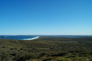
The Royal National Park is a protected national park that is located in Sutherland Shire local government area in the southern portion of Sydney, New South Wales, Australia.

Sutherland Shire is a local government area (LGA) in the southern region of Sydney, in the state of New South Wales, Australia. Sutherland Shire is located approximately 26 kilometres south-southwest of the Sydney central business district, and comprises an area of 370 square kilometres (140 sq mi). As at the 2016 census, Sutherland Shire has an estimated population of 218,464. The area is colloquially known as "The Shire", and has featured in several reality television series.

Cronulla is a suburb of Sydney, in the state of New South Wales, Australia. Boasting numerous surf beaches and swimming spots, the suburb attracts both tourists and Greater Sydney residents. Cronulla is 26 kilometres south of the Sydney central business district, in the local government area of the Sutherland Shire.

Perdido Key State Park is a 247-acre (1.00 km2) Florida State Park located on a barrier island fifteen miles (24 km) southwest of Pensacola, off S.R. 292, in northwestern Florida. The address is 12301 Gulf Beach Highway.

St. Andrews State Park is a 1,200-acre (4.9 km2) Florida State Park located three miles (5 km) east of Panama City Beach Florida, off U.S. 98. It is the headquarters of one of the state's five AmeriCorps Florida State Parks chapters.

Little Bay is a suburb in the Eastern Suburbs of Sydney, in the state of New South Wales, Australia. Little Bay is located 14 kilometres south-east of the Sydney central business district and is part of the local government area of the City of Randwick.

Wamberal is a coastal suburb of the Central Coast region of New South Wales, Australia, just north of Terrigal. It is part of the Central Coast Council local government area and is located adjacent to the Wamberal Lagoon. Wamberal is an Aboriginal word meaning 'where the sea breaks'.

Fairlight is a suburb of northern Sydney, in the state of New South Wales, Australia. Fairlight is located 13 kilometres north-east of the Sydney central business district in the local government area of Northern Beaches Council and is part of the Northern Beaches region.

Fort Pierce Inlet State Park, a 340-acre (1.4 km2) part of the Florida State Park system, is located just north of the Fort Pierce Inlet, on North Hutchinson Island, near Fort Pierce. It consists of beaches, dunes and a coastal hammock between the Atlantic Ocean and the waters of Tucker Cove, an indentation of the Indian River Lagoon.

Rodeo Beach is a beach in the Golden Gate National Recreation Area located in Marin County, California, United States, two miles north of the Golden Gate Bridge. It is characterized by a spit of around 50 meters width at the mouth of a long embayment, known as Rodeo Lagoon; for much of the year the lagoon is cut off from the ocean, making the beach spit a baymouth bar. Part of the beach is sheltered by cliffs. Rodeo Beach is known for its dark, pebbly sand, its uses for surfing and sunbathing, and its locale as a place for viewing, but not collecting, semi-precious stones. This beach is unique among California beaches in that it is largely made up of coarse, pebbly chert grains, both red and green in color. Its mineral composition sets it apart from every other beach in the state. Surfing is possible throughout the year and at all tidal stages, but is best in summer—although there is a risk of shark attacks. Due to the North bar offshore of this beach it results in big waves in the winter months with the big swells that come in. Strong currents make swimming dangerous.

Shelly Beach is a coastal suburb of the Central Coast region of New South Wales, Australia, located east of Tuggerah Lake and bordering the Pacific Ocean south of The Entrance. It is part of the Central Coast Council local government area. It is 66 km south of Newcastle & 93 km north of Sydney. Shelly Beach is considered one of the most popular surfing beaches on the Central Coast.
Munmorah State Conservation Area is located on the Central Coast of New South Wales, Australia. The area's coastal setting and panoramic views, perched sand dunes, diverse vegetation communities, protected threatened species and migratory bird habitats, together with opportunities for nature based recreation and for educational and scientific study, were cited as reasons for the reserve's creation. The reserve is part of the Tuggerah Important Bird Area, identified as such by BirdLife International because of its importance for a variety of water and woodland birds.

Flamenco Beach is a public beach on the Caribbean island of Culebra. It is known for its shallow turquoise waters, white sand, swimming areas, and diving sites. It stretches for a mile around a sheltered, horseshoe-shaped bay. Playa Flamenco is a popular beach destination for both Culebra and Puerto Rico. In March 2014, Flamenco Beach was ranked 3rd best beach in the world with a TripAdvisor Travelers' Choice Award. In August 2016, it was announced that Flamenco Beach had regained its Blue Flag Beach international distinction.

Praia da Amoreira is a beach within the Municipality of Aljezur, in the Algarve, Portugal. The beach is on the western Seaboard in the north west of the Algarve. The beach is 5.4 miles (8.7 km) north west of the village of Aljezur, and is 71.8 miles (115.6 km) north west, by road, from the regions capital of Faro.

Praia do monte Clérigo is a beach within the municipality of Aljezur, in Algarve, Portugal. The beach is on the western Seaboard in the north west of the Algarve. The beach is 5.1 miles (8.2 km) north west of the village of Aljezur, and is 70.0 miles (112.7 km) north west, by road, from the regions capital of Faro. Praia do monte Clérigohas been designated a blue Flag beach (2012).

Greenhills Beach is an unpatrolled beach on Bate Bay, located in Greenhills Beach, Sydney, New South Wales, Australia. The beach is located roughly 18 kilometres from the Sydney central business district, in the local government area of the Sutherland Shire. Recognised as one of Sydney's longest beaches, Greenhills beach is roughly 3 kilometres in length and forms part of a chain of beaches residing on Bate Bay. It is the northernmost section of the Greenhills-North Cronulla beach complex and is the only section of the beach not to be patrolled by a Surf Club or by volunteer lifesavers.

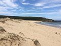
Wedding Cake Rock, also known as White Rock, is a sandstone rock formation located in the Royal National Park near Bundeena in Sydney, New South Wales, Australia, accessible via the Royal National Park Coast Track. The rock is one of many formations that appear north of Marley Beach, and is suspended 25 metres (82 ft) above sea level. Wedding Cake Rock is noted for its scenic location and popularity with bushwalkers and tourists, as an attractive location for photography. Its reputation, however, was damaged after the landmark saw a sudden spike in popularity in 2015, and subsequently fell victim to vandalism. The rock was closed off from public access in May 2015 by the New South Wales National Parks and Wildlife Service, citing the dangerous behavior of recent visitors, and later, safety concerns, after a survey conducted the following month determined that the rock was unstable, and that it would collapse into the Tasman Sea within the next decade.
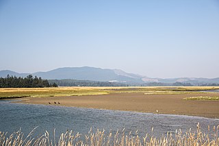
Sitka Sedge State Natural Area is an estuary and beach on the north coast of the U.S. state of Oregon in Tillamook County. Sitka Sedge consists of 357 acres (144 ha) of tidal marsh, mudflats, dunes, forested wetlands, and uplands at the south end of the Sand Lake estuary, north of Tierra Del Mar.