Sydney Cove

Last updated

Sydney Cove, Circular Quay Manly Ferry arrives at Circular Quay.jpg
Sydney Cove, Circular Quay

Sydney Cove (Eora: Warrane [1] ) is a bay on the southern shore of Sydney Harbour, one of several harbours in Port Jackson, on the coast of Sydney, New South Wales. Sydney Cove is a focal point for community celebrations, due to its central Sydney location between the Sydney Opera House and the Sydney Harbour Bridge.

Contents

Sydney Cove was the site of the First Fleet's landing on 26 January 1788 and the subsequent raising of the Union Jack, a seminal date in Australian history now marked as Australia Day.

Sydney Cove, Port Jackson in the County of Cumberland - from a drawing made by Francis Fowkes in 1788 Sydney Cove, Port Jackson in the County of Cumberland - F. F. delineavit, 1769.jpg
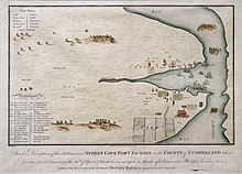
Sydney Cove, Port Jackson in the County of Cumberland – from a drawing made by Francis Fowkes in 1788

History

Circular Quay and mouth of the Tank Stream, Sydney Cove, Frederick Garling Jr., 1839 Circular Quay 1839 V1-FL3198424.jpg
Circular Quay and mouth of the Tank Stream, Sydney Cove, Frederick Garling Jr., 1839
The Founding of Australia by Captain Arthur Phillip RN Sydney Cove January 26th 1788, a 1939 oil painting by Algernon Talmage The Founding of Australia. By Capt. Arthur Phillip R.N. Sydney Cove, Jan. 26th 1788.jpg
The Founding of Australia by Captain Arthur Phillip RN Sydney Cove January 26th 1788, a 1939 oil painting by Algernon Talmage

The Eora name for Sydney Cove was recorded by several early settlers of the First Fleet variously spelt as Warrane, War-ran, Warrang and Wee-rong. The spot is of great significance, as the first meeting place between Eora people and Europeans. Before colonisation of the area, Eora men speared fish from the shoreline, and women line-fished from their nowies (canoes). [2]

Sydney Cove was named after the British Home Secretary, the 1st Baron Sydney (who was later created 1st Viscount Sydney in 1789). It was the site chosen by Captain Arthur Phillip, RN between 21 and 23 January 1788 for the British penal settlement which is now the city of Sydney, and where possession of New South Wales was formally declared on 26 January (now commemorated as Australia Day). [3] Today, the exact site where the flag was planted is unmarked, being a spot near the bottom of Bethel Steps, The Rocks (behind the south end of the present Overseas Passenger Terminal) [4] This site on the west side of the Cove is confirmed by a 1789 letter by John Campbell. [5]

Phillip had been instructed to establish the settlement at Botany Bay, a large bay further south of Sydney Cove which had been discovered by Lieutenant James Cook during his voyage of discovery in 1770, and was recommended by the eminent botanist Sir Joseph Banks, who had accompanied Cook, as a suitable site for a settlement. But Phillip discovered that Botany Bay offered neither a secure anchorage nor a reliable source of fresh water. Sydney Cove offered both of these, being serviced by a freshwater creek which was soon to be known as the Tank Stream. [6]

It must have been like entering paradise on that summer afternoon when the sea-won convoy passed through the dun and barren headlands into the untouched harbour – the water brilliantly blue, the shores high and wooded without being precipitous, a scattering of islands, sandy beaches, the trees shimmering under the sun.
The site of the settlement was Sydney Cove. It was one of the smaller inlets, chosen because it had fresh water and good anchorage for ships close into the land. The Governor's working party had cleared a camping ground beside the creek, which stole silently along through a very thick wood, the stillness of which had then for the first time since the Creation, been interrupted by the rude sound of the labourer's axe. [7]

Sydney Cove medallion Sydney Cove medallion 1789 Josiah Wedgwood a128978.jpg
Sydney Cove medallion

Sydney Cove Medallion

A sample of the dark grey clay of Sydney Cove was collected by Governor Phillip and given to Sir Joseph Banks, who gave it to pottery maker Josiah Wedgwood to test for suitability for making pottery. Wedgwood found it excellent and made a commemorative medal that became known as the Sydney Cove Medallion. [8] [9] [10]

Today

The cove is dual-named as Warrane, the name by which it was known by the Eora people. [11]

The Tank Stream is encased in a concrete drain beneath the streets of the central business district [12] and all native bushland has been cleared. The head of the cove is occupied by the Circular Quay ferry terminal. On Bennelong Point at the northern end of the eastern shore of the cove stands the Sydney Opera House. On the western shore is the historic district known as The Rocks. [13]

Sydney Cove is a focal point for community celebrations, due to its central Sydney location between the Sydney Opera House and the Sydney Harbour Bridge. It is also one of the main congregation points for Sydney New Year's Eve [14] and Australia Day events. [15]

See also

Related Research Articles

<span class="mw-page-title-main">Arthur Phillip</span> British colonial administrator (1738–1814)

Arthur Phillip was a British Royal Navy officer who served as the first governor of the Colony of New South Wales.

<span class="mw-page-title-main">First Fleet</span> 11 British ships establishing an Australian penal colony

The First Fleet was a fleet of 11 British ships that brought the first British colonists and convicts to Australia. It comprised two Royal Navy vessels, three store ships and six convict transports. On 13 May 1787 the fleet under the command of Captain Arthur Phillip, with over 1400 people, left from Portsmouth, England and took a journey of over 24,000 kilometres (15,000 mi) and over 250 days to eventually arrive in Botany Bay, New South Wales, where a penal colony would become the first British settlement in Australia.

<span class="mw-page-title-main">Port Jackson</span> Body of water in Sydney, Australia

Port Jackson, consisting of the waters of Sydney Harbour, Middle Harbour, North Harbour and the Lane Cove and Parramatta Rivers, is the ria or natural harbour of Sydney, New South Wales, Australia. The harbour is an inlet of the Tasman Sea. It is the location of the Sydney Opera House and Sydney Harbour Bridge. The location of the first European settlement and colony on the Australian mainland, Port Jackson has continued to play a key role in the history and development of Sydney.

<span class="mw-page-title-main">History of Sydney</span>

The history of Sydney is the story of the peoples of the land that has become modern Sydney.

<span class="mw-page-title-main">Circular Quay</span> Locality in Sydney, New South Wales, Australia

Circular Quay is a harbour, former working port and now international passenger shipping port, public piazza and tourism precinct, heritage area, and transport node located in Sydney, New South Wales, Australia on the northern edge of the Sydney central business district on Sydney Cove, between Bennelong Point and The Rocks. It is part of the local government area of the City of Sydney.

<span class="mw-page-title-main">North Shore (Sydney)</span> Region in New South Wales, Australia

The North Shore is a region within Northern Sydney, in the state of New South Wales, Australia, generally referring to suburbs located on the northern side of Sydney Harbour up to Wahroonga, and suburbs between Middle Harbour and the Lane Cove River.

<span class="mw-page-title-main">Greenwich, New South Wales</span> Suburb of Sydney, New South Wales

Greenwich is a suburb on the Lower North Shore of Sydney, in the state of New South Wales, Australia. Greenwich is located 7 kilometres (4 mi) north-west of the Sydney central business district, in the local government area of the Municipality of Lane Cove.

<span class="mw-page-title-main">Manly Beach</span>

Manly Beach is a beach situated among the Northern Beaches of Sydney, Australia, in Manly, New South Wales. From north to south, the three main sections are Queenscliff, North Steyne, and South Steyne.

<span class="mw-page-title-main">Bennelong Point</span> Locality in Sydney, New South Wales, Australia

Bennelong Point, a former island in Sydney Harbour, is a headland that, since the 1970s, is the location of the Sydney Opera House in Sydney, New South Wales, Australia.

<span class="mw-page-title-main">The Domain, Sydney</span> Park in Sydney, Australia

The Domain is a heritage-listed 34-hectare (84-acre) area of open space located on the eastern fringe of the Sydney central business district, in the City of Sydney local government area of New South Wales, Australia. Separating the central business district from Woolloomooloo, The Domain adjoins the Royal Botanic Gardens and is managed by the Royal Botanic Gardens Trust, a division of the NSW Office of Environment and Heritage, an agency of the Government of New South Wales. The Domain is used as a venue for outdoor concerts, open-air events, large political gatherings and rallies, as well as being used daily by the people of Sydney for exercise and relaxation. Along with the Royal Botanic Gardens, The Domain was added to the New South Wales State Heritage Register on 2 April 1999.

<span class="mw-page-title-main">Eora</span> Aboriginal Australian nation of New South Wales

The Eora is primarily a construct developed by Aboriginal people from outside the Sydney region to represent themselves as an Aboriginal Australian people of New South Wales. Eora has been claimed to be the name given by the earliest European settlers to Aboriginal people belonging to the clans along the coastal area of what is now known as the Sydney basin, in New South Wales, Australia. The Eora derive their language from the Darug people, whose traditional lands lie in most of the Sydney basin, including those lands claimed to be Eora.

<span class="mw-page-title-main">Tank Stream</span> Heritage-listed stream in Sydney, Australia

The Tank Stream is a heritage-listed former fresh water tributary of Sydney Cove and now tunnel and watercourse located in the Sydney central business district, in the City of Sydney local government area of New South Wales, Australia. The Tank Stream was the fresh water supply for the fledgling colony of New South Wales in the late 18th century. Today it is little more than a storm water drain. It originated from a swamp to the west of present-day Hyde Park and at high tide entered Sydney Cove at what is now the intersection of Bridge and Pitt Streets in the Sydney central business district. The catchment was 65 hectares, corresponding roughly the size of the Sydney central business district. It was added to the New South Wales State Heritage Register on 2 April 1999.

<span class="mw-page-title-main">Sydney central business district</span> Suburb of Sydney, New South Wales, Australia

The Sydney central business district (CBD) is the historical and main commercial centre of Sydney. The CBD is Sydney's city centre, or Sydney City, and the two terms are used interchangeably. Colloquially, the CBD or city centre is often referred to simply as "Town" or "the City". The Sydney city centre extends southwards for about 3 km (2 mi) from Sydney Cove, the point of first European settlement in which the Sydney region was initially established.

<span class="mw-page-title-main">Farm Cove, New South Wales</span>

Farm Cove is a tidal inlet and shallow bay in Sydney Harbour, separated from Sydney Cove by Bennelong Point, New South Wales, Australia. Farm Cove is one of the places around Sydney Harbour that has been officially gazetted as a dual named site by the Geographical Names Board (GNB). The official dual name for this place is: 'Farm Cove / Wahganmuggalee'.

<span class="mw-page-title-main">Botany Bay</span> Open ocean bay in Sydney, Australia

Botany Bay is an open oceanic embayment, located in Sydney, New South Wales, Australia, 13 km (8 mi) south of the Sydney central business district. Its source is the confluence of the Georges River at Taren Point and San Souci as well as the Cooks River at Kyeemagh, which flows 10 km (6 mi) to the east before meeting its mouth at the Tasman Sea, midpoint between the suburbs of La Perouse and Kurnell. The northern headland of the entrance to the bay from the Tasman Sea is Cape Banks and, on the southern side, the outer headland is Cape Solander and the inner headland is Sutherland Point.

The Gadigal, also spelled as Cadigal and Caddiegal, are a group of Aboriginal people whose traditional lands are located in Gadi, on Dharug country, the location of Sydney, New South Wales, Australia.

<span class="mw-page-title-main">Cockle Bay (Sydney)</span> Bay in Sydney, New South Wales

Cockle Bay is a small bay in inner-city Sydney, New South Wales, Australia. It is located on the western edge of the Sydney central business district.

<span class="mw-page-title-main">Bennelong Apartments</span> Residential apartment building and multi-use complex in Sydney, Australia

The Bennelong Apartments is a residential apartment building and multi-use complex on the east side of Sydney's Circular Quay. The buildings were designed by Andrew Andersons and PTW Architects, and completed in 1998.

<span class="mw-page-title-main">Overseas Passenger Terminal</span>

The Overseas Passenger Terminal (OPT), known officially as the Sydney Cove Passenger Terminal, is a public passenger terminal servicing cruise ships and ocean liners located in Circular Quay, Sydney, Australia. Whilst commercial shipping operations on and around the site date from 1792, the current primary structure and waterfront promenade date from 1958, with subsequent on-going alterations and land reclamation throughout the latter part of the 20th century. The current design retains the black steel portal frame trusses of the original 1958 structure, with major additions completed in 1988 in the Post-War International Style through the collaboration of Sydney architects Lawrence Nield and Peter Tonkin.

<span class="mw-page-title-main">Sydney Cove West Archaeological Precinct</span> Historic site in New South Wales, Australia

Sydney Cove West Archaeological Precinct is a heritage-listed precinct that contains The Rocks police station, the Museum of Contemporary Art Australia, car park, parks, shops and roads located at 112–156 George Street, in the inner city Sydney suburb of The Rocks in the City of Sydney local government area of New South Wales, Australia. The precinct previously contained a commissariat store, Maritime Services Board offices, dockyard and Department of Labour & Industry offices. Buildings in the precinct were developed in various stages since 1797 to date, with heritage-listed buildings dating from 1797 to 1939. The precinct is also known as the Museum of Contemporary Art, Maritime Services Board, Colonial Government naval dockyard, Commissariat Stores, Colonial Hospital, Kings and Queens Wharf and First Fleet Park. The property is owned by Property NSW, an agency of the Government of New South Wales. It was added to the New South Wales State Heritage Register on 5 August 2011.

References

  1. "Sydney Cove". Geographical Names Board. Archived from the original on 12 June 2021. Retrieved 16 July 2022.
  2. "Barani". Sydney Cove / Warrane. Retrieved 5 July 2021.
  3. Discover Sydney: Sydney's European History. TravelOnline.com. Retrieved 10 May 2018
  4. Barlass, Tim (16 July 2022). "Why the City of Sydney pays for a British flag to fly near Circular Quay". The Sydney Morning Herald. Retrieved 22 January 2023.
  5. NSW State Library
  6. Sydney Water: The Tank Stream, 2010 leaflet
  7. Eldershaw, Flora; Barnard, Marjorie (1938). Phillip of Australia: an account of the settlement at Sydney Cove, 1788–92. Australia: Angus and Robertson. published under their joint nom de plume M. Barnard Eldershaw
  8. Josiah Wedgwood's Sydney Cove Medallion Archived 21 March 2012 at the Wayback Machine , National Museum of Australia.
  9. National Museum of Australia Sydney Cove Medallion from the museum's Collections Search.
  10. Robert J. King, "'Etruria': the Great Seal of New South Wales", Journal of the Numismatic Association of Australia, vol.5, October 1990, pp.3-8. Archived 29 March 2020 at the Wayback Machine
  11. "Language". Barani. 12 August 1965. Retrieved 5 July 2021.
  12. Hoh, Amanda.The Tank Stream: A historical walk along Sydney's first water supply. ABC News, 7 November 2016. Retrieved 10 May 2018
  13. Sydney Street Directory. Sydney: UBD. 1999. p. 1. ISBN   0-7319-1055-9.
  14. Gorrey, Megan (9 December 2021). "Harbour city to shine beneath New Year's Eve fireworks". The Sydney Morning Herald. Retrieved 10 December 2021.
  15. "What was on". Australia Day Council of NSW. Retrieved 7 August 2022.

Further reading