The Kamay Botany Bay National Park is a heritage-listed protected national park that is located in the eastern part of Botany Bay in Sydney, New South Wales, Australia. The 456-hectare (1,130-acre) national park is situated approximately 16 kilometres (9.9 mi) south-east of the Sydney central business district, on the northern and southern headlands of Botany Bay. The northern headland is at La Perouse and the southern headland is at Kurnell.

Sutherland Shire is a local government area in the southern region of Sydney, in the state of New South Wales, Australia. The Sutherland Shire is located just south of the Sydney CBD, and comprises an area of 370 square kilometres (140 sq mi) and as at the 2016 census and has an estimated population of 218,464. The Sutherland Shire is colloquially known as "The Shire" which has been featured in several reality television series.

Cronulla is a suburb of Sydney, in the state of New South Wales, Australia. Boasting numerous surf beaches and swimming spots, the suburb attracts both tourists and Greater Sydney residents. Cronulla is 26 kilometres south of the Sydney central business district, in the local government area of the Sutherland Shire.

The Towra Point Nature Reserve is a protected nature reserve that is located in Sutherland Shire, Southern Sydney, New South Wales, in eastern Australia. The 603-hectare (1,490-acre) reserve is situated on the southern shores of Botany Bay at Kurnell, within the Sutherland Shire. The reserve is protected under the Ramsar Convention as a wetland of international importance as an important breeding ground for many vulnerable, protected, or endangered species. The Towra Point Aquatic Nature Reserve is located in the surrounding waterways.

Botany Bay is an open oceanic embayment, located in Sydney, New South Wales, Australia, 13 km (8 mi) south of the Sydney central business district. Its source is the confluence of the Georges River at Taren Point and San Souci as well as the Cooks River at Kyeemagh, which flows 10 km (6 mi) to the east before meeting its mouth at the Tasman Sea, midpoint between the suburbs of La Perouse and Kurnell. The northern headland of the entrance to the bay from the Tasman Sea is Cape Banks and, on the southern side, the outer headland is Cape Solander and the inner headland is Sutherland Point.

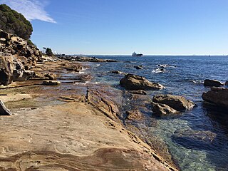
Kurnell is a suburb in Sydney, in the state of New South Wales, Australia. It is 21.4 kilometres (13.3 mi) south of the Sydney central business district, in the local government area of the Sutherland Shire along the east coast. Cronulla and Woolooware are the only adjacent suburbs. La Perouse is located opposite, on the northern headland of Botany Bay. The Cronulla sand dunes are on the south eastern headland of Botany Bay. The eastern side of the peninsula is part of Botany Bay National Park, and Towra Point Nature Reserve is located on the western side of the suburb.

The Dee Why and Curl Curl, were two identical steam ferries servicing Sydney Harbour's Circular Quay to Manly service. Both commissioned in 1928, they were the largest ferries on Sydney Harbour until the 1938 introduction of the South Steyne.

Elouera Beach or Elouera is a patrolled beach on Bate Bay, in Cronulla, Sydney, New South Wales, Australia. The Wall is the local name given to the area between North Cronulla Beach and Elouera.

Bellambi is a suburb of Wollongong in the Illawarra region of New South Wales, Australia. It has a railway station on the NSW TrainLink South Coast Line.

Pasha Bulker, later known as MV Drake and now MV Anthea, is a Panamax bulk carrier of 76,741 tonnes deadweight (DWT) operated by the Lauritzen Bulkers shipping company and owned by Japanese Disponent Owners. While waiting in the open ocean outside Newcastle harbour to load coal, Pasha Bulker ran aground during a major storm on 8 June 2007 on Nobbys Beach, New South Wales, Australia. It was refloated and moved to a safe location offshore on 2 July 2007 before being towed to Japan for major repairs on 26 July 2007.

The Cronulla sand dunes, also known officially as the Cronulla Sand Dune and Wanda Beach Coastal Landscape, are an open space, heritage-listed nature conservation, and visitor attraction located on the Kurnell Peninsula at Lindum Road, Kurnell within the Sutherland Shire local government area of Sydney, New South Wales, Australia. Formerly, it was a site for sand mining, film making, and had use as pastoral property. It is also known as part of Kurnell Peninsula Headland and Cronulla Sand Hill. It was added to the New South Wales State Heritage Register on 26 September 2003.

The Koonya was a wood carvel screw steamer built in 1887 at Hobart, that was wrecked when it stuck the shore at Doboy reef whilst carrying passengers & cargo between Moruya and Sydney and was lost off Cronulla Beach, Port Hacking, New South Wales on 25 January 1898.

Greenhills Beach is an unpatrolled beach on Bate Bay, located in Greenhills Beach, Sydney, New South Wales, Australia. The beach is located roughly 18 kilometres from the Sydney central business district, in the local government area of the Sutherland Shire. Recognised as one of Sydney's longest beaches, Greenhills beach is roughly 3 kilometres in length and forms part of a chain of beaches residing on Bate Bay. It is the northernmost section of the Greenhills-North Cronulla beach complex and is the only section of the beach not to be patrolled by a Surf Club or by volunteer lifesavers.
SS Oakland was a small general cargo/passenger ship commissioned in 1890, Dumbarton, Scotland, for New South Wales, Australia, timber merchant William T Yeager. It sank off Cabbage Tree Island, New South Wales, in 1903, with the loss of 11 lives.

The Lyman D. Foster was an ocean-going, cargo-carrying, wooden sailing vessel named after the son of a provisions merchant who invested in vessels. Built at the Hall Brother's shipyard at Port Blakely, Washington (state), U.S.A. in 1892, she was 184 feet long with a 39-feet beam and 15.4 feet depth, and had a tonnage of 778 GRT.

Sixty-miler (60-miler) is the colloquial name for the ships that were used in the coastal coal trade of New South Wales, Australia. The sixty-milers delivered coal to Sydney from ports and ocean jetties to the north and south. The name refers to the approximate distance by sea, the distance is 64 nautical miles from the Hunter River mouth at Nobbys Head to the North Head of Sydney Harbour.
Fernleigh is a heritage-listed former boatshed and homestead and now residence located at 44-46 Fernleigh Road, Caringbah South in the Sutherland Shire local government area of New South Wales, Australia. It is also known as Mandalay and York House. The property is privately owned. It was added to the New South Wales State Heritage Register on 2 April 1999.

The Stone Fleet was the colloquial name for the small coastal ships that carried crushed-stone construction aggregate to Sydney from the Illawarra ports of Kiama and Shellharbour and the nearby ocean jetties at Bombo and Bass Point.

Silver Beach is a 2.8 km (1.7 mi) long west-trending sand spit in Kurnell, Sydney, New South Wales, Australia that is located 18 km (11 mi) south of the Sydney CBD. Situated on the northwestern reaches of the Kurnell Peninsula and linked with the sandstone of Sutherland Point in the east, the beach is characterised by silver-coloured sands, hence the name, and fourteen rockwall groynes which project into Botany Bay. The eastern point of the beach is the site where Captain James Cook first set foot on Australian soil in 1770, which marked the beginning of Britain's interest in Australia and in the eventual colonisation of this new "southern continent".

Rock Davis (1833-1904) was a shipbuilder, mainly associated with his shipyard, the Rock Davis shipyard, colloquially known as 'the Big Shed', on Brisbane Water at Blackwall, New South Wales, Australia. After his death, the business of ship building was carried on by his second son, also Rock Davis. The shipyard constructed around 165 wooden-hulled vessels, between 1862 and 1913.
