Ramsgate Beach, New South Wales

Last updated

Ramsgate Beach
Sydney,  New South Wales
Cook Park, Ramsgate Beach.jpg
Cook Park, Ramsgate Beach
Ramsgate Beach, New South Wales
Population1,660 (2016 census) [1]
Postcode(s) 2217
Location16 km (10 mi) south of Sydney CBD
LGA(s) Bayside Council
State electorate(s) Rockdale
Federal Division(s) Cook
Suburbs around Ramsgate Beach:
Kogarah Monterey
Ramsgate Ramsgate Beach Botany Bay
Sans Souci Sans Souci

Ramsgate Beach is a suburb in southern Sydney, in the state of New South Wales, Australia. Ramsgate Beach is located 16 kilometres south of the Sydney central business district, in the Bayside Council and is part of the St George area. The postcode is 2217. Ramsgate is a separate suburb, to the west.

Contents

History

The area between the Cooks River and Georges River was originally known as Seven Mile Beach. It was changed to Lady Robinson’s Beach in 1874 to honour Governor Sir Hercules Robinson’s wife. Cook Park is named after Samuel Cook who advocated it as a public pleasure area. Ramsgate was named after the seaside resort in England. A model village was originally planned for the suburb but later abandoned. [2]

Geography

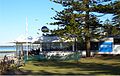
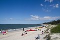
Ramsgate Beach is surrounded by the suburbs of Monterey, Ramsgate and Sans Souci. Lady Robinson Beach and Cook Park run along the eastern border of Ramsgate Beach, on Botany Bay. The suburb is mostly residential with a shopping strip including a supermarket on Ramsgate Road, near The Grand Parade. Another shopping strip, including the post office, is located in Ramsgate on Rocky Point Road, near the intersection of Ramsgate Road.

Population

According to the 2016 census of Population, there were 1,660 people usually resident in Ramsgate Beach. 58.4% of people were born in Australia. 52.0% of people spoke only English at home. Other languages spoken at home included Greek at 12.6%. The most common responses for religious affiliation were Catholic 23.6%, Eastern Orthodox 18.5% and Anglican 12.8%. [1]

Landmarks

Related Research Articles

Botany, New South Wales Suburb of Sydney, New South Wales, Australia

Botany is a suburb in south-eastern Sydney, in the state of New South Wales, Australia. Botany is located 11 kilometres south of the Sydney central business district and is part of the Bayside Council.

Caringbah Suburb of Sydney, New South Wales, Australia

Caringbah is a suburb in southern Sydney, in the state of New South Wales, Australia. Caringbah is 24 kilometres (15 mi) south of the Sydney central business district in the local government area of Sutherland Shire.

Lakemba, New South Wales Suburb of City of Canterbury-Bankstown, New South Wales, Australia

Lakemba is a suburb south west of Sydney, in the state of New South Wales, Australia. Lakemba is located 12 kilometres south west of the Sydney central business district, in the local government area of the City of Canterbury-Bankstown.

Dolls Point, New South Wales Suburb of Sydney, New South Wales, Australia

Dolls Point is a small suburb in southern Sydney, in the state of New South Wales, Australia. Dolls Point is located 17 km south of the Sydney central business district and is part of the St George area. Dolls Point is in the local government area of the Bayside Council.

Brighton-Le-Sands, New South Wales Suburb of Sydney, New South Wales, Australia

Brighton-Le-Sands, is a suburb in southern Sydney, in the state of New South Wales, Australia. Brighton-Le-Sands is located 13 kilometres south of the Sydney central business district, on the western shore of Botany Bay. Brighton-Le-Sands is in the local government area of the Bayside Council and is part of the St George area.

Kogarah, New South Wales Suburb of Sydney, New South Wales, Australia

Kogarah is a suburb of southern Sydney, in the state of New South Wales, Australia. Kogarah is located 14 kilometres south of the Sydney central business district and is considered to be the centre of the St George area.

St George (Sydney) Region in New South Wales, Australia

St George Area refers to an old County Council formed by the local councils of several southern suburbs in Sydney, in the state of New South Wales, Australia. The area includes all the suburbs in the local government area of Georges River Council and the part of Bayside Council which was Rockdale City prior to 2016. The eastern boundary of the district is Lady Robinson Beach on Botany Bay.

Sans Souci, New South Wales Suburb of Sydney, New South Wales, Australia

Sans Souci is a southern Sydney suburb in the state of New South Wales, Australia. Sans Souci is 17 kilometres south of the Sydney central business district and lies across the local government areas of the Bayside Council and the Georges River Council. It is part of the St George area.

Sandringham, New South Wales Suburb of Sydney, New South Wales, Australia

Sandringham is a suburb in southern Sydney, in the state of New South Wales, Australia. Sandringham is located 18 kilometres south of the Sydney central business district and is part of the St George area. Sandringham is in the local government area of the Bayside Council.

Roselands, New South Wales Suburb of Sydney, New South Wales, Australia

Roselands is a suburb in south-western Sydney, in the state of New South Wales, Australia. Roselands is located 16 kilometres south-west of the Sydney central business district in the City of Canterbury-Bankstown.

Ramsgate, New South Wales Suburb of Sydney, New South Wales, Australia

Ramsgate is a suburb in southern Sydney, in the state of New South Wales, Australia 16 km south of the Sydney central business district. It is part of the St George area. Divided by Rocky Point Road, part of Ramsgate to the east of Rocky Point Road is in the local government area of the Bayside Council, whilst properties to the west of Rocky Point Road are in the Georges River Council. Ramsgate Beach is a separate suburb, to the east.

Monterey, New South Wales Suburb of Sydney, New South Wales, Australia

Monterey is a suburb in southern Sydney, in the state of New South Wales, Australia 15 km south of the Sydney central business district and is part of the St George area. Monterey is in the local government area of the Bayside Council.

Kogarah Bay, New South Wales Suburb of Sydney, New South Wales, Australia

Kogarah Bay is a suburb in southern Sydney, in the state of New South Wales, Australia 16 kilometres south of the Sydney central business district. It is part of the St George area. Kogarah Bay is in the local government area of the Georges River Council.

Kyeemagh Suburb of Sydney, New South Wales, Australia

Kyeemagh is a suburb in southern Sydney, in the state of New South Wales, Australia. It is 12 kilometres south of the Sydney central business district, on the western shore of Botany Bay. Kyeemagh is in the local government area of the Bayside Council and is part of the St George area.

Peakhurst Heights, New South Wales Suburb of Sydney, New South Wales, Australia

Peakhurst Heights is a suburb in southern Sydney, in the state of New South Wales, Australia. Peakhurst Heights is located 22 kilometres south of the Sydney central business district and is part of the St George area. Peakhurst Heights is in the local government area of the Georges River Council.

Belfield, New South Wales Suburb of Sydney, New South Wales, Australia

Belfield is a suburb of Sydney, in the state of New South Wales, Australia. It is 8 miles (13 km) southwest of the Sydney central business district, in the local government area of the City of Canterbury-Bankstown and partly in the Municipality of Strathfield.

Croydon Park, New South Wales Suburb of Sydney, New South Wales, Australia

Croydon Park is a suburb in the Inner West of Sydney, in the state of New South Wales, Australia. Croydon Park is 10 kilometres south-west of the Sydney central business district and is divided between the local government areas of the City of Canterbury-Bankstown, Municipality of Burwood and Inner West Council. Croydon is a separate suburb, to the north.

Beverley Park, New South Wales Suburb of Sydney, New South Wales, Australia

Beverley Park is a suburb in southern Sydney, in the state of New South Wales, Australia. Beverley Park is located 15 kilometres south of the Sydney central business district, in the Georges River Council and is part of the St George area.

Blakehurst, New South Wales Suburb of Sydney, New South Wales, Australia

Blakehurst is a suburb in southern Sydney, in the state of New South Wales, Australia 18 kilometres south of the Sydney central business district, in the local government area of the Georges River Council. It is part of the St George area.

Lady Robinsons Beach

Lady Robinsons Beach is the stretch of beach between the mouth of the Cooks River and the mouth of Georges River on the western shore of Botany Bay in Sydney, New South Wales, Australia. Originally known as Seven Mile Beach, it was renamed after the wife of the then Governor, Sir Hercules Robinson. Isolated settlements separated from the beach by sand dunes were also given the name of Lady Robinson's Beach as their postal address.

References

  1. 1 2 Australian Bureau of Statistics (27 June 2017). "Ramsgate Beach (State suburb)". 2016 Census QuickStats. Retrieved 11 April 2018. OOjs UI icon edit-ltr-progressive.svg
  2. The Book of Sydney Suburbs, Compiled by Frances Pollon, Angus & Robertson Publishers, 1990, Published in Australia ISBN   0-207-14495-8, pages 216-217

Coordinates: 33°58′55″S151°08′53″E / 33.982°S 151.148°E / -33.982; 151.148