
Rhodes is an Inner West suburb of Sydney, in the state of New South Wales, Australia. Rhodes is located 12 kilometres west of the Sydney central business district, in the local government area of the City of Canada Bay. It was formerly part of Concord Municipality until a merger with Drummoyne Council to form Canada Bay in December 2000.

Warrawee is a suburb on the Upper North Shore of Sydney in the state of New South Wales, Australia. Warrawee is located 17 kilometres north-west of the Sydney Central Business District, in the local government area of Ku-ring-gai Council. Warrawee is predominantly a residential suburb with few commercial entities. Notably, its railway station supports no commercial activities, which is uncommon on the Sydney train network.

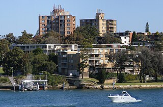
Seaforth is a suburb of Northern Sydney, in the state of New South Wales, Australia. Seaforth is located 12 kilometres north-east of the Sydney central business district in the local government area of Northern Beaches Council and is part of the Northern Beaches region.

Cheltenham is a suburb in the Northern Sydney region of Sydney, in the state of New South Wales, Australia. Cheltenham is 18 kilometres north-west of the Sydney central business district in the local government area of Hornsby Shire.
Glenhaven is a semi rural suburb of Sydney, in the state of New South Wales, Australia 32 kilometres north-west of the Sydney central business district in the local government areas of The Hills Shire and Hornsby Shire, part of the Hills District region.

North Epping is a suburb of Sydney, in the state of New South Wales, Australia 19 kilometres north-west of the Sydney central business district in the local government area of Hornsby Shire. North Epping is in the Northern Sydney region, and is often referred to as part of the "North-West" or North Shore. Epping is a separate suburb to the south and under the Parramatta City Council, which shares the postcode of 2121.

Cremorne is a suburb on the Lower North Shore of Sydney, New South Wales, Australia, located 6 kilometres north-east of the Sydney central business district, in the local government area of North Sydney Council.

Zetland is an inner southern suburb of Sydney, New South Wales, Australia 4 kilometres south of the Sydney central business district, in the local government area of the City of Sydney. The postcode is 2017.

Marsfield is a suburb in the Northern Sydney region of Sydney, in the state of New South Wales, Australia. Marsfield is located 16 kilometres north-west of the Sydney central business district in the local government area of the City of Ryde.

Cremorne Point is a harbourside suburb on the Lower North Shore of Sydney, New South Wales, Australia located six kilometres north of the Sydney central business district, in the local government area of North Sydney Council.

Woolwich is a suburb on the Lower North Shore of Sydney, in the state of New South Wales, Australia. Woolwich is located 11 kilometres north-west of the Sydney central business district, in the local government area of the Municipality of Hunter's Hill. Woolwich sits on the peninsula between the Lane Cove River and the Parramatta River, jutting out from Hunters Hill.

Northwood is a suburb on the Lower North Shore of Sydney, in the state of New South Wales, Australia, eight kilometres north-west of the Sydney central business district, in the local government area of the Municipality of Lane Cove. Northwood is on the northern side of the Lane Cove River between Woodford Bay and Gore Creek.

North Parramatta is a suburb on the North Shore of Sydney, in the state of New South Wales, Australia. North Parramatta is 24 kilometres north-west of the Sydney central business district in the local government area of the City of Parramatta.
Chiswick is a suburb in the Inner West of Sydney, in the state of New South Wales, Australia. It is located 9 kilometres west of the Sydney central business district in the local government area of the City of Canada Bay. Chiswick sits on the peninsula between Abbotsford Bay and Five Dock Bay, on the Parramatta River. It is surrounded by the suburbs of Abbotsford, Russell Lea and Drummoyne.

Church Point is a suburb in the Northern Beaches region of Sydney, in the state of New South Wales, Australia. Church Point is 32 kilometres north of the Sydney central business district, in the local government area of Northern Beaches Council.

Denistone West is a suburb in Northern Sydney, in the state of New South Wales, Australia. Denistone West is located 16 kilometres north-west of the Sydney central business district in the local government area of the City of Ryde. Denistone and Denistone East are separate suburbs; Denistone West was gazetted as a suburb in its own right on 5 February 1999.

East Killara is a suburb on the Upper North Shore of Sydney in the state of New South Wales, Australia. East Killara is located 15 kilometres north of the Sydney Central Business District in the local government area of Ku-ring-gai Council. It is bordered by Garigal national park to the East and Eastern Arterial Rd/ Birdwood Ave to the west. Killara is a separate suburb to the south-west, which shares the postcode of 2071.

Fairlight is a suburb of northern Sydney, in the state of New South Wales, Australia. Fairlight is located 13 kilometres north-east of the Sydney central business district in the local government area of Northern Beaches Council and is part of the Northern Beaches region.

Lane Cove North is a suburb on the Lower North Shore of Sydney, in the state of New South Wales, Australia. Lane Cove North is located 11 kilometres north-west of the Sydney central business district, in the local government areas of the Municipality of Lane Cove and the City of Willoughby. Lane Cove and Lane Cove West are separate suburbs.

Kurraba Point is a harbourside suburb on the lower North Shore of Sydney, New South Wales, Australia. Kurraba Point is located 4 kilometres north of the Sydney central business district, in the local government area of North Sydney Council.

