Related Research Articles

A beach is a landform alongside a body of water which consists of loose particles. The particles composing a beach are typically made from rock, such as sand, gravel, shingle, pebbles, etc., or biological sources, such as mollusc shells or coralline algae. Sediments settle in different densities and structures, depending on the local wave action and weather, creating different textures, colors and gradients or layers of material.
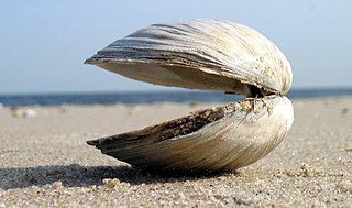
Clam is a common name for several kinds of bivalve molluscs. The word is often applied only to those that are edible and live as infauna, spending most of their lives halfway buried in the sand of the seafloor or riverbeds. Clams have two shells of equal size connected by two adductor muscles and have a powerful burrowing foot. They live in both freshwater and marine environments; in salt water they prefer to burrow down into the mud and the turbidity of the water required varies with species and location; the greatest diversity of these is in North America.

Ku-ring-gai Chase National Park is a national park on the northern side of Sydney in New South Wales, Australia. The 14,977-hectare (37,010-acre) park is 25 kilometres (16 mi) north of the Sydney central business district and generally comprises the land east of the M1 Pacific Motorway, south of the Hawkesbury River, west of Pittwater and north of Mona Vale Road. It includes Barrenjoey Headland on the eastern side of Pittwater.

Oyster is the common name for a number of different families of salt-water bivalve molluscs that live in marine or brackish habitats. In some species, the valves are highly calcified, and many are somewhat irregular in shape. Many, but not all oysters are in the superfamily Ostreoidea.

Bivalvia, in previous centuries referred to as the Lamellibranchiata and Pelecypoda, is a class of marine and freshwater molluscs that have laterally compressed bodies enclosed by a shell consisting of two hinged parts. As a group, bivalves have no head and they lack some usual molluscan organs like the radula and the odontophore. They include the clams, oysters, cockles, mussels, scallops, and numerous other families that live in saltwater, as well as a number of families that live in freshwater. The majority are filter feeders. The gills have evolved into ctenidia, specialised organs for feeding and breathing. Most bivalves bury themselves in sediment where they are relatively safe from predation. Others lie on the sea floor or attach themselves to rocks or other hard surfaces. Some bivalves, such as the scallops and file shells, can swim. The shipworms bore into wood, clay, or stone and live inside these substances.
Landforms are categorized by characteristic physical attributes such as their creating process, shape, elevation, slope, orientation, rock exposure, and soil type.

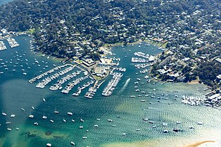
Pittwater Council was a local government area on the Northern Beaches of Sydney, in the state of New South Wales, Australia. It covered a region adjacent to the Tasman Sea about 30 kilometres (19 mi) north of the Sydney central business district. The area is named after Pittwater, the body of water adjacent to much of the area governed. First proclaimed in 1906 as the A Riding of Warringah Shire, the area was proclaimed as the Municipality of Pittwater on 1 May 1992. On 12 May 2016, the Minister for Local Government announced that Pittwater Council would be subsumed into the newly formed Northern Beaches Council. The last Mayor of Pittwater Council was Councillor Jacqui Townsend, an independent politician.
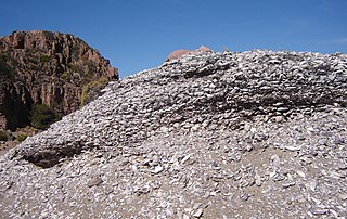
A midden is an old dump for domestic waste which may consist of animal bone, human excrement, botanical material, mollusc shells, potsherds, lithics, and other artifacts and ecofacts associated with past human occupation.

Whaleback Shell Midden is a shell midden, or dump, consisting primarily of oyster shells located on the east side of the Damariscotta River in Maine, United States. It is preserved as a Maine state historic site and was included as part of the Damariscotta Oyster Shell Heaps listed on the National Register of Historic Places in 1969. Other shell middens are located on the estuary in both Damariscotta and Newcastle. The middens in this area were formed over about 1,000 years between 200 BC to AD 1000.

Scotland Island is an island and suburb on the Northern Beaches of Sydney, in the state of New South Wales, Australia. Church Point, Scotland Island's major mainland service locality, is located 32 kilometres north of the Sydney central business district, in the local government area of Northern Beaches Council.
Newport is a suburb of northern Sydney in the state of New South Wales, Australia, in the local government area of Northern Beaches Council. It is part of the Northern Beaches region.

Lady Robinsons Beach is the stretch of beach between the mouth of the Cooks River and the mouth of Georges River on the western shore of Botany Bay in Sydney, New South Wales, Australia. Originally known as Seven Mile Beach, it was renamed after the wife of the then Governor, Sir Hercules Robinson. Isolated settlements separated from the beach by sand dunes were also given the name of Lady Robinson's Beach as their postal address.

Chepiwanoxet is a neighborhood in Warwick, Rhode Island, with an island peninsula in Greenwich Bay, an arm of Narragansett Bay. The neighborhood straddles the Amtrak railroad lines, which lies just east of and parallel to the Post Road. Its boundaries are Neptune Street to the North, Alger Avenue to the South, Post Road to the West, and Greenwich Bay to the East. Chepiwanoxet Way, an underpass beneath the Amtrak lines, now serves as the only street access in and out of the neighborhood.

The St. Johns culture was an archaeological culture in northeastern Florida, USA that lasted from about 500 BCE until shortly after European contact in the 17th century. The St. Johns culture was present along the St. Johns River and its tributaries (including the Oklawaha River, and along the Atlantic coast of Florida from the mouth of the St. Johns River south to a point east of the head of the St. Johns River, near present-day Cocoa Beach, Florida. At the time of first European contact, the St. Johns culture area was inhabited by speakers of the Mocama, Agua Fresca and Acuera dialects of the Timucua language and by the Mayacas.

Ōmana Regional Park is situated south-east of Auckland and just west of Maraetai, in the Franklin area of the Auckland Region of New Zealand's North Island. It is owned and managed by Auckland Council.

Gathering seafood by hand can be as easy as picking shellfish or kelp up off the beach, or doing some digging for clams or crabs, or perhaps diving under the water for abalone or lobsters.

Patchogue Bay is a lagoon on the south-central shores of Long Island in the U.S. state of New York.

The cuisine of Gower, a peninsula in south Wales, is based on ingredients grown, raised or collected on or around the peninsula. The cuisine is based on fresh ingredients with recipes based around a fish or meat dish. Until the twentieth century, the peninsula was virtually cut off from other markets due to poor roads, and no rail connection. The result was that Gower became self-sufficient in food.

Nielsen Park is a heritage-listed historic site, park and nature reserve located at Greycliffe Avenue, Vaucluse in the Municipality of Woollahra local government area of New South Wales, Australia. The traditional lands of the Birrabirragal indigenous people, the park was designed by John Frederick Hilly, James Barnet and the Office of the New South Wales Government Architect. It is also known as Vaucluse Estate, Greycliffe Estate and Greycliffe House. It was added to the New South Wales State Heritage Register on 28 August 2017.